This article needs additional citations for verification .(April 2019) |
| This article is part of a series on the | ||||||||||||||||||
| City of Dallas | ||||||||||||||||||
|---|---|---|---|---|---|---|---|---|---|---|---|---|---|---|---|---|---|---|
| ||||||||||||||||||
This article traces the history of Dallas, Texas (USA) during the city's modern period from 1996 to the present.
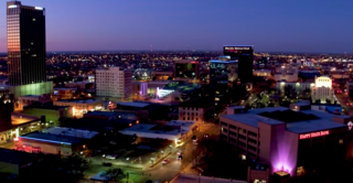
In the late 1990s, the booming telecom industry exploded in Dallas, especially in areas like Las Colinas and the Telecom Corridor. During this time, Dallas became known as Texas's Silicon Valley, or the "Silicon Prairie." [1]
Following the dot-com bubble-burst and the 11 September attacks on New York City and Washington, D.C., the city slipped into recession from damage to two of its vital industries — transportation and telecommunications.
By 2004, signs of an economic turnaround began to appear. In 2005, three towers began construction amid tens of residential conversions and smaller residential projects. By the year 2010, the North Central Texas Council of Governments expects 10,000 residents to live within the loop. Just north, Uptown is one of the hottest real estate markets in the country. At the beginning of 2006, nine highrise residential buildings or hotels were under construction in that area. Leading the way is the US$500 million phase two of Victory Park, a $3 billion+ project. At full build-out, it should contain more than 4,000 residences and 4,000,000 square feet (370,000 m2) of office and retail space.
The Arts District in downtown is also expected to become a major point of growth. As the Dallas Center for the Performing Arts Foundation implements construction on several new projects in its master plan for the area. When the new Winspear Opera House (Foster and Partners) and Wyly Theatre (Office for Metropolitan Architecture - Rem Koolhaas) join the existing Nasher Sculpture Center (Renzo Piano) and Meyerson Symphony Center (I.M. Pei and Partners), Dallas will be the only city in the world that has four buildings within one contiguous block that are all designed by Pritzker Architecture Prize winners.

Dallas served as a major refuge city for 2005's Hurricane Katrina and Rita. Reunion Arena and the Dallas Convention Center served as evacuee camps for thousands in the months following the storms. In all, 46,000 evacuees filled Texas public schools after Katrina in the fall of 2005 — the largest increases in the Dallas area took place in the Dallas Independent School District with 1,900 new students, Arlington ISD with 1,069, Richardson ISD with 964, and Fort Worth ISD with 846. [2]
An estimated half a million people attended the largest mass gathering in Dallas history and perhaps state history. [3]

Dallas is the third largest city in Texas and the largest city in the Dallas–Fort Worth metroplex, the fourth largest metropolitan area in the United States at 7.5 million people. It is the largest city in and seat of Dallas County with portions extending into Collin, Denton, Kaufman, and Rockwall counties. With a 2020 census population of 1,304,379, it is the ninth most populous city in the U.S. and the third largest city in Texas after Houston and San Antonio. Located in the North Texas region, the city of Dallas is the main core of the largest metropolitan area in the Southern United States and the largest inland metropolitan area in the U.S. that lacks any navigable link to the sea.

Frisco is a city in Collin and Denton counties in the U.S. state of Texas. It is part of the Dallas–Fort Worth metroplex and about 25 miles (40 km) from both Dallas Love Field and Dallas/Fort Worth International Airport. Its population was 200,509 at the 2020 U.S. census.

Garland is a city in the U.S. state of Texas. It is located northeast of Dallas and is a part of the Dallas–Fort Worth metroplex. It is located within Dallas County except for small portions located in Collin and Rockwall Counties. At the 2010 census, the city had a population of 226,876. In 2019, the population rose to 239,928, making it the 93rd-most populous city in the United States of America and the 12th-most populous city in Texas; by 2020, it had a population of 246,018. Garland is the third largest city in Dallas County by population and has access to downtown Dallas via public transportation including two Dart Blue Line stations and buses.
Amarillo is a city in the U.S. state of Texas and the seat of Potter County. It is the 14th-most populous city in Texas and the largest city in the Texas Panhandle. A portion of the city extends into Randall County. The estimated population of Amarillo was 200,393 as of April 1, 2020. The Amarillo-Pampa-Borger combined statistical area had an estimated population of 308,297 as of 2020.

The Houston Independent School District (HISD) is the largest public school system in Texas, and the eighth-largest in the United States. Houston ISD serves as a community school district for most of the city of Houston and several nearby and insular municipalities in addition to some unincorporated areas. Like most districts in Texas it is independent of the city of Houston and all other municipal and county jurisdictions. The district has its headquarters in the Hattie Mae White Educational Support Center in Houston.
The Telecom Corridor is a technology business center in Richardson, Texas, a northern suburb of Dallas, which contains over 25 million square feet of office space and accounts for over 130,000 jobs. Located in the Dallas/Fort Worth area and home to the University of Texas at Dallas, the Corridor is a strip about 6.5 miles (10.5 km) long along U.S. Route 75 (US 75), between President George Bush Turnpike and Interstate 635 (I-635) and is often considered an area of the Silicon Prairie. More than 5,700 companies, including 600 technology companies are headquartered in the area, including significant players such as AT&T, Alcatel-Lucent, Ericsson, Verizon, Samsung, Texas Instruments, and MetroPCS. Some of these companies also have offices in Telecom Valley located in California. Although the Telecom Corridor was a booming area of Dallas's economy during the late 1990s, the dot-com bust of 2000 hit the region hard. However, it began recovering in 2004, and that recovery has since picked up momentum, gaining both the operations of many non-technology-related companies and many previously non-existent residential units designed in the New Urbanist style. The name "Telecom Corridor" is a registered trademark and may technically only be used to describe the area mentioned in this article.
This article traces the history of Dallas, Texas,.

The Dallas Independent School District is a school district based in Dallas, Texas (USA). It operates schools in much of Dallas County and is the second-largest school district in Texas and the seventeenth-largest in the United States. It is also known as Dallas Public Schools (DPS).
Alief is a working-class suburb in Southwest Harris County, Texas, United States. Most of Alief is within the city limits of Houston, while a portion of the community is in unincorporated Harris County.

As the center of Hurricane Katrina passed southeast of New Orleans on August 29, 2005, winds downtown were in the Category 1 range with frequent intense gusts. The storm surge caused approximately 23 breaches in the drainage canal and navigational canal levees and flood walls. As mandated in the Flood Control Act of 1965, responsibility for the design and construction of the city's levees belongs to the United States Army Corps of Engineers and responsibility for their maintenance belongs to the Orleans Levee Board. The failures of levees and flood walls during Katrina are considered by experts to be the worst engineering disaster in the history of the United States. By August 31, 2005, 80% of New Orleans was flooded, with some parts under 15 feet (4.6 m) of water. The famous French Quarter and Garden District escaped flooding because those areas are above sea level. The major breaches included the 17th Street Canal levee, the Industrial Canal levee, and the London Avenue Canal flood wall. These breaches caused the majority of the flooding, according to a June 2007 report by the American Society of Civil Engineers. The flood disaster halted oil production and refining which increased oil prices worldwide.
The article covers the Hurricane Katrina effects by region, within the United States and Canada. The effects of Hurricane Katrina, in late August 2005, were catastrophic and widespread. It was one of the deadliest natural disasters in U.S. history, leaving at least 1,836 people dead, and a further 135 missing. The storm was large and had an effect on several different areas of North America.
The Trinity River Project is a public works project undertaken in the 2000s in the city of Dallas, Texas, United States. Its goal is to redevelop the Trinity River. The project aims to turn the river's path into a collection of sports fields, trails, nature centers, and recreational opportunities. At 10,000 acres (4,000 ha), it is one of the larger urban parks in the United States.
This article is about education in Dallas, Texas (USA).
Vickery Meadow is an ethnically-diverse neighborhood consisting almost exclusively of apartment complexes in Northeast Dallas, Texas, United States. The Vickery Midtown Public Improvement District states the neighborhood is bounded by Northwest Highway, Royal Lane, Central Expressway, and Abrams. The City of Dallas Office of Economic Development states that the boundaries of the Vickery Meadow Tax Increment Financing district, which was established in 2005, are “the east side of the intersection of US 75 and Park Lane and extends eastward along Park Lane to the ‘Five Points’ intersection at Park Lane, Fair Oaks Avenue and Ridgecrest Road.” Leslie Minora of the Dallas Observer described it as "a dense swath of about 100 apartment complexes cradled by NorthPark Center and Whole Foods to the west and Half Price books [sic] to the south. It's an overlooked anthill, population 25,000, packed with people here by circumstance."

The Mercantile National Bank Building is a 31-story, 159.4 m (523 ft) skyscraper at 1800 Main Street in the Main Street district of downtown Dallas, Texas. It is the former home of the Mercantile National Bank, which later became MCorp Bank. The design of the skyscraper features Moderne styling from the Art Deco era and was designed by Walter W. Ahlschlager. The building has a series of setbacks that is crowned by an ornamental four-sided clock along with a decorative weather spire. The Merc was the main element of a four-building complex that eventually spanned a full city block.
The Dubai government's decision to diversify from a trade-based, oil-reliant economy to one that is service and tourism-oriented has made real estate and other developments more valuable, resulting in a property boom from 2004 to 2006. Construction on a large scale has turned Dubai into one of the fastest-growing cities in the world. There are a number of large-scale projects which are currently under construction or will be constructed in the future. Due to the heavy construction which is taking place in Dubai, 30,000 construction cranes, which are 25% of cranes worldwide, are operating in Dubai. Due to the burst of construction, Dubai has acquired various building-related records, which include: the world's tallest tower, the world's largest shopping mall, the world's largest fountain and the world's tallest hotel. Also under construction is Dubailand, which will be almost twice the size of the Walt Disney World Resort.

Southwest Management District, formerly Greater Sharpstown Management District, is a district in Houston, Texas, United States. The district is split into 6 neighborhoods: Sharpstown, Chinatown, Mahatma Gandhi District/Little India, Westwood, Harwin, and University.

Cedar Hill is a city in Dallas and Ellis counties in the U.S. state of Texas. It is located approximately 16 miles (26 km) southwest of downtown Dallas and is situated along the eastern shore of Joe Pool Lake and Cedar Hill State Park. Per the 2020 United States census, the population was 49,148. Cedar Hill is a suburb of the city of Dallas and is part of the Best Southwest area, which includes the nearby cities of DeSoto, Duncanville, and Lancaster.
The Telecom Corridor Genealogy Project is the result of the collaboration of the Richardson Chamber of Commerce and the Center for Information Technology and Management (CITM) in the School of Management at the University of Texas at Dallas, with the purpose of creating not only a multidimensional diagram of the relationship of companies and their employees in the high tech sector, but also to enable professionals in the tech sector to interact in a social networking framework that has certain advantages over general websites such as LinkedIN.

Downtown Dallas is the central business district (CBD) of Dallas, Texas, United States, located in the geographic center of the city. It is the second-largest business district in the state of Texas. The area termed "Downtown" has traditionally been defined as bounded by the downtown freeway loop, bounded on the east by I-345 (although known and signed as the northern terminus of I-45 and the southern terminus of US 75, on the west by I-35E, on the south by I-30, and on the north by Woodall Rodgers Freeway.
| By period | |
|---|---|
| By topic | |
| By city | |
| Government agency | |
