History of local government districts in Middlesex

Last updated

The History of local government districts in Middlesex outside the metropolitan area began in 1835 with the formation of poor law unions. This was followed by the creation of various forms of local government body to administer the rapidly growing towns of the area. By 1934 until its abolition in 1965, the entire county was divided into urban districts or municipal boroughs.

Contents

Poor law unions

The parishes of the county were grouped under the Poor Law Amendment Act 1834 to form unions. Each union had a single workhouse, and was administered by a board of guardians elected by the parish ratepayers. The boundaries of the unions would later be used to define rural sanitary districts in 1875 and rural districts in 1894. Poor law unions were abolished in 1930 by the Local Government Act 1929.

Map of the poor law unions in 1840 Middlesex poor law 1840.png
Map of the poor law unions in 1840
NameParishesNotes
Barnet PLUFriern Barnet, Finchey, Monken Hadley, South MimmsRemainder of PLU in Hertfordshire
Brentford PLUActon, Chiswick, Ealing, Greenford, Hanwell, Heston, Isleworth, New Brentford, Old Brentford, Perivale, Twickenham, West Twyford
Edmonton PLUEdmonton, Enfield, Hornsey, Southgate, Tottenham, Wood GreenIncluded the parish of Hampstead (in the Metropolis) until 1848, Waltham Holy Cross in Essex and Cheshunt in Hertfordshire
Hendon PLUEdgware, Great Stanmore, Harrow on the Hill, Harrow Weald, Hendon, Kingsbury, Little Stanmore, Pinner, Wealdstone, Wembley, Willesden (until 1896)
Kingston PLUHampton, Hampton Wick, TeddingtonMajority of PLU in Surrey
Staines PLUAshford, Cranford, East Bedfont, Feltham, Hanworth, Harlington, Harmondsworth, Laleham, Littleton, Shepperton, Staines, Stanwell, Sunbury
Uxbridge PLUCowley, Harefield, Hayes, Hillingdon, Ickenham, Northolt, Northwood, Ruislip, Uxbridge, West Drayton, Yiewsley
Willesden Poor Law ParishWillesdenFormed 1896

Local boards of health

An outbreak of cholera in Tottenham forced the creation of a temporary local board of health in 1831/32. Following the enactment of the Public Health Act 1848 (11 & 12 Vict. c. 63), permanent boards could be formed on petition of the inhabitants or where there was excess mortality. The first local board in England formed under the Act was at Uxbridge in 1849, and it was followed by a number of other towns. The Local Government Act 1858 simplified the process of creating local councils: ratepayers of a parish or area could adopt the Act by resolution, whereupon it would become a Local Government District, governed by a Local Board. [1] Numerous localities in Middlesex took the opportunity, and it also provided the mechanism for the developing communities of Southgate and Wood Green to separate themselves from the control of the Edmonton and Tottenham boards.

Sanitary districts

The system was rationalised by the Public Health Act 1875 (38 & 39 Vict. c. 55), which designated all municipal boroughs, local board districts, local government districts and improvement commissioners districts in England and Wales as urban sanitary districts. The existing local authority became an urban sanitary authority, without change of title. Also created were rural sanitary districts, which were identical in area to poor law unions, less any urban sanitary district. The poor law guardians for the parishes in the district became the rural sanitary authority.

List of districts 1848–1894

Local boards and urban sanitary districts 1848–1894

Local board districts (LBDs) were created by the Public Health Act 1848 (11 & 12 Vict. c. 63) and governed by a local board of health; local government districts (LGDs) were created by the Local Government Act 1858 and governed by a local board. Chiswick was an improvement commissioners district (ICD) created by local act of Parliament.

NameFormedArea covered
Acton LGD1865Parish of Acton [2]
Chiswick ICD1858Parish of Chiswick [3]
Ealing LGD1863Parish of Ealing less chapelry of Old Brentford [4]
Edmonton LBD1850Originally covered entire parish of Edmonton.
In 1881 the Southgate area formed a separate LGD. [5] The boundary with Enfield LBD was adjusted in 1883. [6]
Enfield LBD1850Most of the parish of Enfield, part of Edmonton parish from 1883. [6] [7]
Hampton LGD1890Parish of Hampton [8]
Hampton Wick LGD1863Hamlet of Hampton Wick (part of Hampton parish)
Constituted separate parish in 1866. [6]
Harrow LBD1850Part of the parish of Harrow-on-the Hill (Harrow on the Hill, Roxeth, and parts of Greenhill and Sudbury) [9]
Hornsey LGD1867The part of the parish of Hornsey not included in South Hornsey LGD. [10] Gained part of Friern Barnet parish in 1883. [11]
South Hornsey LGD1863Part of the parish of Hornsey (Brownswood Park) [12]
Teddington LGD1867Parish of Teddington [13]
Tottenham LBD1850Parish of Tottenham: Wood Green area became a separate LGD in 1888. [14]
Twickenham LGD1868Parish of Twickenham [15]
Uxbridge LBD1849Hamlet (later parish) of Uxbridge and western part of parish of Hillingdon. [16]
Friern Barnet LGD1883Most of parish of Friern Barnet [11]
Brentford LGD1874Chapelries of Old Brentford (Ealing parish) and New Brentford (Hanwell parish) [4]
Finchley LGD1878Parish of Finchley [17]
Hanwell LGD1885Parish of Hanwell [18]
Hendon LGD1879Parish of Hendon [19]
Heston and Isleworth LGD1875Parishes of Heston and Isleworth [20]
Norwood LGD1891Parish of Norwood [6]
Southgate LGD1881Southgate area of Edmonton parish. [5]
Staines LGD1872Parish of Staines [21]
Willesden LGD1874Parish of Willesden [22]
Wood Green LGD1888Wood Green area of Tottenham parish. [14]
East Barnet Valley LGD1863Part of Monken Hadley parish [23]
Remainder of LGD in Hertfordshire.
Barnet LGD1863Part of Monken Hadley parish [23]
Remainder of LGD in Hertfordshire.

Rural sanitary districts 1875–1894

NameNotesArea covered
Barnet RSDMostly in HertfordshireParishes of Finchley (until 1878), Friern Barnet (until 1883), South Mimms.
Became South Mimms Rural District in 1894.
Brentford RSD Parishes of Greenford, Hanwell (until 1885), Perivale, West Twyford.
Became Greenford UD in 1894.
Edgware RSDRenamed Hendon RSD 1877 [19] Parishes of Edgware, Great Stanmore, Kingsbury, Little Stanmore and Pinner; and part of the parish of Harrow on the Hill (Harrow Weald, Wealdstone and Wembley areas).
Became Hendon RD, Wealdstone UD, Wembley UD in 1894.
Kingston RSDMostly in SurreyParish of Hampton (until 1890).

No Middlesex parishes after 1890.

Staines RSD Parishes of Ashford, Cranford, East Bedfont, Feltham, Hanworth, Harlington, Harmondsworth, Laleham, Littleton, Shepperton, Stanwell and Sunbury.
Became Staines RD, Sunbury on Thames UD 1894.
Uxbridge RSD Parishes of Cowley, Harefield, Hayes, Ickenham, Northolt, Northwood (until 1891), Ruislip and West Drayton and part of Hillingdon parish.
Became Uxbridge RD in 1894.

County districts 1894–1965

The Local Government Act 1894 (56 & 57 Vict. c. 73) divided the administrative county into four rural districts and thirty-one urban districts, based on existing sanitary districts. One urban district, South Hornsey was a detached part of Middlesex within the County of London until 1900, when it was transferred to the latter county. [6] The rural districts were Hendon, South Mimms, Staines and Uxbridge. Because of increasing urbanisation these had all been abolished by 1934. [24] Urban districts had been created, merged, and many had gained the status of municipal borough by 1965. The districts as at the 1961 census were: [25]

Municipal history 1894–1965Borough
incorporation
District/borough in 1965Population
1951 [25]
Population
1961 [25]
1965 fate [26]
Acton UD formed 18941921 Acton MB 67,471 Red Arrow Down.svg 65,586LB Ealing
Brentford UD, Chiswick UD formed 1894,
amalgamated as Brentford and Chiswick UD 1927
1932 Brentford and Chiswick MB 59,367 Red Arrow Down.svg 54,833LB Hounslow
Ealing UD created 1894,
absorbed Greenford UD, Hanwell UD 1926
1901 Ealing MB 187,323 Red Arrow Down.svg 183,077LB Ealing
Edmonton UD created 18941937 Edmonton MB 104,270 Red Arrow Down.svg 91,956LB Enfield
Enfield UD created 18941955 Enfield MB 110,465 Red Arrow Down.svg 109,542LB Enfield
Feltham UD created 1904 from Staines RD,
absorbed East Bedfont, Hanworth on abolition of Staines RD 1934
n/a Feltham UD 44,861 Green Arrow Up.svg 51,047LB Hounslow
Finchley UD created 18941933 Finchley MB 69,991 Red Arrow Down.svg 69,370LB Barnet
Friern Barnet UD created 1894n/a Friern Barnet UD 29,163 Red Arrow Down.svg 28,813LB Barnet
Harrow on the Hill UD created 1894,
Harrow UD formed 1934 from Harrow on the Hill UD
part of abolished Wealdstone UD,
Harrow Weald, Pinner, Little Stanmore, Great Stanmore
from abolished Hendon RD
1954 Harrow MB 219,494 Red Arrow Down.svg 209,080LB Harrow
(boundaries unchanged)
Hayes UD created 1904 from part of Uxbridge RD,
Hayes and Harlington UD created 1930 by merger of Hayes UD
and Cranford and Harlington from abolished Staines RD
n/a Hayes and Harlington UD 65,596 Green Arrow Up.svg 67,915LB Hillingdon
Hendon UD created 1894, absorbed Edgware from Hendon RD 19311932 Hendon MB 155,857 Red Arrow Down.svg 151,843LB Barnet
Heston and Isleworth UD created 18941932 Heston and Isleworth MB 106,847 Red Arrow Down.svg 103,013LB Hounslow
Hornsey UD created 18941903 Hornsey MB 98,159 Red Arrow Down.svg 97,962LB Haringey
South Mimms RD created 1894, became Potters Bar UD 1934n/a Potters Bar UD 17,172 Green Arrow Up.svg 23,376Hertfordshire
Created 1904 from part of Uxbridge RDn/a Ruislip-Northwood UD 68,288 Green Arrow Up.svg 72,791LB Hillingdon
Southall Norwood UD created 1894, renamed Southall 19361936 Southall MB 55,896 Red Arrow Down.svg 52,983LB Ealing
Southgate UD created 18941933 Southgate MB 73,377 Red Arrow Down.svg 72,359LB Enfield
Created 1894,
absorbed Ashford, Laleham and Stanwell from abolished Staines RD 1930
n/a Staines UD 39,995 Green Arrow Up.svg 49,838Surrey
Created 1894,
absorbed Littleton and Shepperton from abolished Staines RD 1930
n/a Sunbury-on-Thames UD 23,394 Green Arrow Up.svg 33,437Surrey
Tottenham UD created 18941934 Tottenham MB 126,929 Red Arrow Down.svg 113,249LB Haringey
Twickenham UD created 1894,
absorbed Hampton UD, Hampton Wick UD, Teddington UD 1937
1926 Twickenham MB 105,663 Red Arrow Down.svg 100,971LB Richmond
Uxbridge UD created 1894,
absorbed Cowley, Harefield, Hillingdon East and Ickenham
from abolished Uxbridge RD 1929
1955 Uxbridge MB 55,960 Green Arrow Up.svg 63,941LB Hillingdon
Wembley UD created 1894,
absorbed Kingsbury UD, part of abolished Wealdstone UD 1934
1937 Wembley MB 131,384 Red Arrow Down.svg 124,892LB Brent
Willesden UD created 18941933 Willesden MB 179,697 Red Arrow Down.svg 171,001LB Brent
Wood Green UD created 18941933 Wood Green MB 52,228 Red Arrow Down.svg 47,945LB Haringey
Yiewsley UD created 1911 from part of Uxbridge RD,
absorbed Harmondsworth, West Drayton from abolished Uxbridge RD
to become Yiewsley and West Drayton UD 1929
n/a Yiewsley and West Drayton UD 20,468 Green Arrow Up.svg 23,723LB Hillingdon

Related Research Articles

<span class="mw-page-title-main">Middlesex</span> Historic county of England

Middlesex was a county in southeast England. Its area was almost entirely within the wider urbanised area of London and mostly within the ceremonial county of Greater London, with small sections in neighbouring ceremonial counties. The county's boundaries largely followed three rivers: the Thames in the south, the Lea to the east and the Colne to the west. A line of hills formed the northern boundary with Hertfordshire.

<span class="mw-page-title-main">Metropolitan Borough of Stoke Newington</span> Former London borough, United Kingdom

The Metropolitan Borough of Stoke Newington was a metropolitan borough in the County of London between 1900 and 1965 when it became part of the London Borough of Hackney.

<span class="mw-page-title-main">Barnet Urban District</span>

Barnet was a local government district in south Hertfordshire from 1863 to 1965 around the town of Barnet.

<span class="mw-page-title-main">Municipal Borough of Finchley</span>

Finchley, which is now in north London, was a local government district in Middlesex, England, from 1878 to 1965. Finchley Local Board first met in 1878. It became Finchley Urban District Council in 1895 and the Municipal Borough of Finchley in 1933. In 1965 Middlesex was abolished and Finchley became part of the London Borough of Barnet.

<span class="mw-page-title-main">Municipal Borough of Hornsey</span>

The Municipal Borough of Hornsey was a local government district in east Middlesex from 1867 to 1965.

<span class="mw-page-title-main">Municipal Borough of Tottenham</span>

Tottenham was a local government district in north east Middlesex from 1850 to 1965. It was part of the London postal district and Metropolitan Police District.

<span class="mw-page-title-main">Municipal Borough of Wood Green</span>

Wood Green was a local government district in south east Middlesex from 1888 to 1965.

<span class="mw-page-title-main">Municipal Borough of Uxbridge</span>

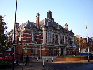
Uxbridge was a local government district in north west Middlesex, England, from 1849 to 1965, seated in the town of Uxbridge.

<span class="mw-page-title-main">Potters Bar Urban District</span>

Potters Bar Urban District was a local government district in England from 1894 to 1974, covering the town of Potters Bar and the village of South Mimms. The district was initially called the South Mimms Rural District, being renamed in 1934.

A poor law union was a geographical territory, and early local government unit, in Great Britain and Ireland.

<span class="mw-page-title-main">Local Government Act 1894</span> United Kingdom legislation

The Local Government Act 1894 was an Act of the Parliament of the United Kingdom that reformed local government in England and Wales outside the County of London. The Act followed the reforms carried out at county level under the Local Government Act 1888. The 1894 legislation introduced elected councils at district and parish level.

Sanitary districts were established in England and Wales in 1872 and in Ireland in 1878. The districts were of two types, based on existing structures:

<span class="mw-page-title-main">London Government Act 1963</span> United Kingdom legislation

The London Government Act 1963 is an act of the Parliament of the United Kingdom, which created Greater London and a new local government structure within it. The Act significantly reduced the number of local government districts in the area, resulting in local authorities responsible for larger areas and populations. The upper tier of local government was reformed to cover the whole of the Greater London area and with a more strategic role; and the split of functions between upper and lower tiers was recast. The Act classified the boroughs into inner and outer London groups. The City of London and its corporation were essentially unreformed by the legislation. Subsequent amendments to the Act have significantly amended the upper tier arrangements, with the Greater London Council abolished in 1986, and the Greater London Authority introduced in 2000. As of 2016, the London boroughs are more or less identical to those created in 1965, although with some enhanced powers over services such as waste management and education.

<span class="mw-page-title-main">Uxbridge Rural District</span>

Uxbridge Rural District was, from 1894 to 1929, a local government district in Middlesex, England.

<span class="mw-page-title-main">Staines Rural District</span>

Staines Rural District was a rural district of Middlesex in England from 1894 to 1930.

Hornsey was an ancient parish in the county of Middlesex. It was both a civil parish, used for administrative purposes, and an ecclesiastical parish of the Church of England.

Billinge was, from 1872 to 1974, a local government district in the administrative county of Lancashire, England.

<span class="mw-page-title-main">South Hornsey</span>

South Hornsey was a local government district in Middlesex, England from 1865 to 1900.

The History of local government districts in Buckinghamshire began in 1835 with the formation of poor law unions. This was followed by the creation of various forms of local government body. In 1894 the existing arrangements were replaced with a system of municipal boroughs, urban and rural districts, which remained in place until 1974.

<span class="mw-page-title-main">Municipal Borough of Slough</span> Former municipal borough

Slough was, from 1863 to 1974, a local government district in southern Buckinghamshire, England. It became an urban district in 1894 and was incorporated as a municipal borough in 1938. It was abolished in 1974 and now forms part of the borough of Slough in Berkshire.

References

  1. Royston Lambert, Central and Local Relations in Mid-Victorian England: The Local Government Act Office, 1858-71, Victorian Studies, Vol. 6, No. 2. (Dec., 1962), pp. 121-150.
  2. "Acton - Local Government". A History of the County of Middlesex: Volume 7. 1982. Retrieved 25 February 2008.
  3. "Chiswick - Local Government". A History of the County of Middlesex: Volume 7. 1982. Retrieved 25 February 2008.
  4. 1 2 "Ealing and Brentford - Introduction". A History of the County of Middlesex: Volume 7. 1982. Retrieved 25 February 2008.
  5. 1 2 "Edmonton - Local Government". A History of the County of Middlesex: Volume 5. 1976. Retrieved 25 February 2008.
  6. 1 2 3 4 5 Frederic A Youngs, Guide to the Local Administrative Units of England, Volume I: Southern England, London, 1979
  7. "Enfield - Local Government". A History of the County of Middlesex: Volume 5. 1976. Retrieved 25 February 2008.
  8. Hampton & Hampton Hill, Twickenham Museum, accessed February 25, 2008 Archived October 27, 2007, at the Wayback Machine
  9. Harrow London Borough, Wellcome Library website (archived by Wayback Machine), accessed February 26, 2008
  10. "Hornsey, including Highgate - Local Government". A History of the County of Middlesex: Volume 6. 1980. Retrieved 26 February 2008.
  11. 1 2 "Friern Barnet - Local Government". A History of the County of Middlesex: Volume 6. 1980. Retrieved 26 February 2008.
  12. "Hornsey, including Highgate - Introduction". A History of the County of Middlesex: Volume 6. 1980. Retrieved 26 February 2008.
  13. Teddington, Twickenham Museum, accessed February 26, 2008 Archived October 27, 2007, at the Wayback Machine
  14. 1 2 "Tottenham - Local Government". A History of the County of Middlesex: Volume 5. 1976. Retrieved 26 February 2008.
  15. "Twickenham - Local Government". A History of the County of Middlesex: Volume 3. 1962. Retrieved 26 February 2008.
  16. "Hillingdon, including Uxbridge - Local Government". A History of the County of Middlesex: Volume 4. 1971. Retrieved 26 February 2008.
  17. "Finchley - Local government". A History of the County of Middlesex: Volume 6. 1980. Retrieved 26 February 2008.
  18. "Hanwell - Local government". A History of the County of Middlesex: Volume 3. 1962. Retrieved 26 February 2008.
  19. 1 2 "Hendon - Local government". A History of the County of Middlesex: Volume 5. 1976. Retrieved 26 February 2008.
  20. "Heston and Isleworth - Local government". A History of the County of Middlesex: Volume 3. 1962. Retrieved 26 February 2008.
  21. "Staines - Local government". A History of the County of Middlesex: Volume 3. 1962. Retrieved 26 February 2008.
  22. "Willesden - Local government". A History of the County of Middlesex: Volume 7. 1982. Retrieved 26 February 2008.
  23. 1 2 "Monken Hadley - Local Government". A History of the County of Middlesex: Volume 5. 1976. Retrieved 26 February 2008.
  24. Great Britain Historical GIS / University of Portsmouth, Middlesex . Retrieved 2008-02-20.
  25. 1 2 3 Great Britain Historical GIS / University of Portsmouth, Census 1961: Middlesex  population . Retrieved 2008-02-20.
  26. Office of Public Sector Information - London Government Act 1963 (as amended). Retrieved on 20 February 2008.