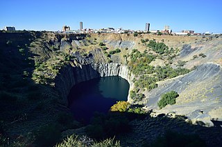
Kimberley is the capital and largest city of the Northern Cape province of South Africa. It is located approximately 110 km east of the confluence of the Vaal and Orange Rivers. The city has considerable historical significance due to its diamond mining past and the siege during the Second Anglo-Boer war. British businessmen Cecil Rhodes and Barney Barnato made their fortunes in Kimberley, and Rhodes established the De Beers diamond company in the early days of the mining town.

Khoekhoe are the traditionally nomadic pastoralist indigenous population of South Africa. They are often grouped with the hunter-gatherer San peoples. The designation "Khoekhoe" is actually a kare or praise address, not an ethnic endonym, but it has been used in the literature as an ethnic term for Khoe-speaking peoples of Southern Africa, particularly pastoralist groups, such as the Griqua, Gona, Nama, Khoemana and Damara nations. The Khoekhoe were once known as Hottentots, a term now considered offensive.

The Northern Cape is the largest and most sparsely populated province of South Africa. It was created in 1994 when the Cape Province was split up. Its capital is Kimberley. It includes the Kalahari Gemsbok National Park, part of the Kgalagadi Transfrontier Park and an international park shared with Botswana. It also includes the Augrabies Falls and the diamond mining regions in Kimberley and Alexander Bay.

The Griquas are a subgroup of mixed-race heterogeneous formerly Xiri-speaking nations in South Africa with a unique origin in the early history of the Dutch Cape Colony. Like the Boers they migrated inland from the Cape and in the 19th century established several states in what is now South Africa and Namibia. The Griqua consider themselves as being South Africa’s first multiracial nation with people descended directly from Dutch settlers in the Cape, and local peoples.
ǃOrakobab or Khoemana, also known as Korana, ǃOra, or Griqua, is a moribund Khoe language of South Africa.

Griqualand West is an area of central South Africa with an area of 40,000 km2 that now forms part of the Northern Cape Province. It was inhabited by the Griqua people – a semi-nomadic, Afrikaans-speaking nation of mixed-race origin, who established several states outside the expanding frontier of the Cape Colony. It was also ancestral home to the Tswana and Khoisan peoples.

Philippolis is a town in the Free State province of South Africa. The town is the birthplace of writer and intellectual Sir Laurens van der Post, actress Brümilda van Rensburg and Springboks rugby player Adriaan Strauss. It is regarded as one of the first colonial settlements in the Free State.

Campbell is a small town situated on the edge of the Ghaap Plateau in the Northern Cape province of South Africa. It is located 48 km east of Griquatown on the N8 road. It was originally known as Knovel Valley and then Groote Fontein, but was renamed in honour of the Reverend John Campbell who visited the Cape Colony in 1813.

The R31 is a provincial route in the Northern Cape of South Africa that connects Kimberley with the Namibian border at Rietfontein via Kuruman and Hotazel. It is co-signed with the R360 between Askham and Andriesvale.

The McGregor Museum in Kimberley, South Africa, originally known as the Alexander McGregor Memorial Museum, is a multidisciplinary museum which serves Kimberley and the Northern Cape, established in 1907.
The Diocese of Kimberley and Kuruman is a diocese in the Anglican Church of Southern Africa, and encompasses the area around Kimberley and Kuruman and overlaps the Northern Cape Province and North West Province of South Africa. It is presided over by the Bishop of Kimberley and Kuruman, until recently Ossie Swartz. On 19 September 2021 the Electoral College of Bishops elected to translate the Right Revd Brian Marajh of George to become the 13th Bishop of Kimberley & Kuruman. The seat of the Bishop of Kimberley and Kuruman is at St Cyprian's Cathedral, Kimberley. There had been so far 12 bishops of the See, though one of these served for two different periods of time.
Driekops Eiland is a rock engraving or petroglyph site in the bed of the Riet River close to the town of Plooysburg, near Kimberley, Northern Cape, South Africa.
Wildebeest Kuil Rock Art Centre is a rock engraving site with visitor centre on land owned by the !Xun and Khwe San situated about 16 km from Kimberley, Northern Cape, South Africa. It is a declared Provincial Heritage Site managed by the Northern Cape Rock Art Trust in association with the McGregor Museum. The engravings exemplify one of the forms often referred to as ‘Bushman rock art' – or Khoe-San rock art – with the rock paintings of the Drakensberg, Cederberg and other regions of South Africa being generally better known occurrences. Differing in technique, the engravings have many features in common with rock paintings. A greater emphasis on large mammals such as elephant, rhino and hippo, in addition to eland, and an often reduced concern with depicting the human form set the engravings apart from the paintings of the sub-continent.
Kousop, birth date unknown, killed in a battle at Slypklip, Vaal River, near Kimberley, Northern Cape, South Africa, on 6 July 1858, was the leader of a group of San or Khoe-San who inhabited the area between the Modder, Riet and Vaal Rivers, western Orange Free State, in the mid nineteenth century.

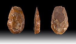
The Nooitgedacht Glacial Pavements comprise a geological feature between Kimberley and Barkly West, South Africa, pertaining to the Palaeozoic-age Dwyka Ice Age, or Karoo Ice Age, where the glacially scoured ancient bedrock was used, substantially more recently, during the Later Stone Age period in the late Holocene as panels for rock engravings.

Elizabeth Dipuo Peters is a South African politician who is the Deputy Minister of Small Business Development of the Republic of South Africa from 7 March 2023. She was previously the Minister of Transport from 10 July 2013 until 30 March 2017, in the Zuma administration, and former Minister of Energy from 2009 to 2013 having served as successor to Manne Dipico as the second Premier of the Northern Cape Province, 22 April 2004 to 10 May 2009. A member of the African National Congress (ANC), she serves on the Women's League National Executive Committee. Dipuo Peters resigned as a member of parliament for the African National Congress in April 2017.
Manne Emsley Dipico, first Premier of the Northern Cape Province, South Africa, was born in Kimberley on 21 April 1959. He was appointed Chairman of the Nuclear Energy Corporation of South Africa (Necsa) in 2006. He is Chairman of Ponahalo Holdings and Deputy Chairman of De Beers Consolidated Mines Ltd. He is the first President of SA-China People's Friendship Association.

Daniëlskuil is a town in ZF Mgcawu District Municipality in the Northern Cape province of South Africa.
The Northern Cape Heritage Resources Authority, previously called Ngwao Boswa jwa Kapa Bokone, and commonly known as 'Boswa', is a provincial heritage resources authority established in 2003 by the MEC for Sport, Arts and Culture in the Northern Cape Province of South Africa, and reconstituted in terms of the Northern Cape Heritage Resources Authority Act, 2013. It is an institution set up under the terms of the National Heritage Resources Act. It is mandated to care for that part of South Africa's national estate that is of provincial and local significance in the Northern Cape.