Okiep

Last updated
Okiep

O'okiep
Chimney, Okiep.JPG
Ventilation shaft built by the Cape Copper Company in 1880
South Africa Northern Cape location map.svg
Red pog.svg
Okiep
South Africa adm location map.svg
Red pog.svg
Okiep
Coordinates: 29°35′45″S17°52′51″E / 29.59583°S 17.88083°E / -29.59583; 17.88083 Coordinates: 29°35′45″S17°52′51″E / 29.59583°S 17.88083°E / -29.59583; 17.88083
Country South Africa
Province Northern Cape
District Namakwa
Municipality Nama Khoi
Area
[1]
  Total38.63 km2 (14.92 sq mi)
Population
(2011) [1]
  Total6,304
  Density160/km2 (420/sq mi)
Racial makeup (2011)
[1]
   Black African 3.8%
   Coloured 93.8%
   Indian/Asian 0.3%
   White 1.1%
  Other1.0%
First languages (2011)
[1]
   Afrikaans 96.2%
   Xhosa 1.0%
  Other2.7%
Time zone UTC+2 (SAST)
Postal code (street)
8270
PO box
8270
Area code 027

Okiep is a small town in the Northern Cape province of South Africa, and was in the 1870s ranked as having the richest copper mine in the world. The town is on the site of a spring that was known in the Khoekhoe language of the Nama people as U-gieb (large brackish place) and was originally spelled as O'okiep. [2]

Northern Cape Province of South Africa

The Northern Cape is the largest and most sparsely populated province of South Africa. It was created in 1994 when the Cape Province was split up. Its capital is Kimberley. It includes the Kalahari Gemsbok National Park, part of the Kgalagadi Transfrontier Park, an international park shared with Botswana. It also includes the Augrabies Falls and the diamond mining regions in Kimberley and Alexander Bay. The Namaqualand region in the west is famous for its Namaqualand daisies. The southern towns of De Aar and Colesberg, in the Great Karoo, are major transport nodes between Johannesburg, Cape Town and Port Elizabeth. In the northeast, Kuruman is known as a mission station and also for its artesian spring, the Eye of Kuruman. The Orange River flows through the province, forming the borders with the Free State in the southeast and with Namibia to the northwest. The river is also used to irrigate the many vineyards in the arid region near Upington.

South Africa Republic in the southernmost part of Africa

South Africa, officially the Republic of South Africa (RSA), is the southernmost country in Africa. It is bounded to the south by 2,798 kilometres (1,739 mi) of coastline of Southern Africa stretching along the South Atlantic and Indian Oceans; to the north by the neighbouring countries of Namibia, Botswana, and Zimbabwe; and to the east and northeast by Mozambique and Eswatini (Swaziland); and it surrounds the enclaved country of Lesotho. South Africa is the largest country in Southern Africa and the 25th-largest country in the world by land area and, with over 57 million people, is the world's 24th-most populous nation. It is the southernmost country on the mainland of the Old World or the Eastern Hemisphere. About 80 percent of South Africans are of Sub-Saharan African ancestry, divided among a variety of ethnic groups speaking different African languages, nine of which have official status. The remaining population consists of Africa's largest communities of European (White), Asian (Indian), and multiracial (Coloured) ancestry.

Khoekhoe language The most widespread of those languages of southern Africa which contain many "click" sounds and have therefore been loosely classified as Khoisan languages

The Khoekhoe language, Khoekhoegowab, also known by the ethnic term Nama and formerly as Hottentot, is the most widespread of those non-Bantu languages of southern Africa that contain "click" sounds and have therefore been loosely classified as Khoisan. It belongs to the Khoe language family, and is spoken in Namibia, Botswana, and South Africa by three ethnic groups, the Nama, Damara, and Haiǁom.

Contents

History

Early settlers in the Cape Colony heard rumours of mountains in the north-west that were fabulously rich in copper. Governor Simon van der Stel was inclined to believe these tales when, in 1681, a group of Namas visited the Castle in Cape Town and brought along some pure copper. Van der Stel himself led a major expedition in 1685 and reached the fabled mountains on 21 October. Three shafts were sunk and revealed a rich lode of copper ore - the shafts exist to this day. For almost 200 years nothing was done about the discovery, largely because of its remote location. The explorer James Alexander was the first to follow up on van der Stel's discovery. In 1852 he examined the old shafts, discovered some other copper outcrops and started mining operations. Prospectors, miners and speculators rushed to the area, but many companies collapsed when the logistical difficulties became apparent.

Cape Colony Dutch and British colony in Southern Africa

The Cape of Good Hope, also known as the Cape Colony, was a British colony in present-day South Africa, named after the Cape of Good Hope. The British colony was preceded by an earlier Dutch colony of the same name, the Kaap de Goede Hoop, established in 1652 by the Dutch East India Company. The Cape was under Dutch rule from 1652 to 1795 and again from 1803 to 1806. The Dutch lost the colony to Great Britain following the 1795 Battle of Muizenberg, but had it returned following the 1802 Peace of Amiens. It was re-occupied by the UK following the Battle of Blaauwberg in 1806, and British possession affirmed with the Anglo-Dutch Treaty of 1814.

Simon van der Stel Dutch explorer

Simon van der Stel was the last Commander and first Governor of the Cape Colony, the Dutch settlement at the Cape of Good Hope in South Africa.

Nama people ethnic group

Nama are an African ethnic group of South Africa, Namibia and Botswana. They traditionally speak the Nama language of the Khoe-Kwadi language family, although many Nama also speak Afrikaans. The Nama are the largest group of the Khoikhoi people, most of whom have largely disappeared as a group, except for the Namas. Many of the Nama clans live in Central Namibia and the other smaller groups live in Namaqualand, which today straddles the Namibian border with South Africa.

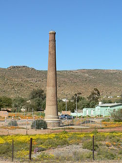
The first miners were Cornish, and brought with them the expertise of centuries of tin-mining in Cornwall. The ruins of the buildings they constructed as well as the stonework of the bridges and culverts of the railway built to transport the ore to Port Nolloth, can still be seen. The Namaqualand Railway started operating in 1876 and lasted for 68 years, carrying ore to Port Nolloth and returning with equipment and provisions. The carriages were initially pulled by mules and horses, which were later replaced by steam locomotives - the last of these, the Clara, stands at Nababeep. Nowadays road transport is used to convey the ore to the railhead at Bitterfontein. The other principal mines of the area are at Carolusberg and Nababeep.

Cornish people ethnic group

The Cornish people or Cornish are a Celtic ethnic group native to, or associated with Cornwall and a recognised national minority in the United Kingdom, which can trace its roots to the ancient Britons who inhabited southern and central Great Britain before the Roman conquest. Many in Cornwall today continue to assert a distinct identity separate from or in addition to English or British identities. Cornish identity has been adopted by migrants into Cornwall, as well as by emigrant and descendant communities from Cornwall, the latter sometimes referred to as the Cornish diaspora. Although not included as an explicit option in the UK census, the numbers of those claiming Cornish ethnic and national identity are officially recognised and recorded.

Cornwall County of England

Cornwall is a county in South West England in the United Kingdom. The county is bordered to the north and west by the Celtic Sea, to the south by the English Channel, and to the east by the county of Devon, over the River Tamar which forms most of the border between them. Cornwall forms the westernmost part of the South West Peninsula of the island of Great Britain. The furthest southwestern point of Great Britain is Land's End; the southernmost point is Lizard Point. Cornwall has a population of 563,600 and covers an area of 3,563 km2 (1,376 sq mi). The county has been administered since 2009 by the unitary authority, Cornwall Council. The ceremonial county of Cornwall also includes the Isles of Scilly, which are administered separately. The administrative centre of Cornwall, and its only city, is Truro.

Port Nolloth Place in Northern Cape, South Africa

Port Nolloth is a town and small domestic seaport in the Namaqualand region on the northwestern coast of South Africa, 144 kilometres (89 mi) northwest of Springbok. It is the seat of the Richtersveld Local Municipality.

The Cape Copper Company Medal for the Defence of O'okiep Okiep00.jpg
The Cape Copper Company Medal for the Defence of O'okiep

Okiep’s mine saw action on 4 April 1902 during the Anglo-Boer war when some 700 officers and men of the 3rd Battalion Queen's Royal Regiment, 5th Royal Warwickshire Regiment, Namaqualand Border Scouts, the Town Guard and the Cape Garrison Artillery, withstood a 30-day siege by Jan Smuts’ forces. The village of Concordia with a garrison of 100 men, surrendered a day after the siege started. On 4 May 1902 a British relief column arrived from Port Nolloth and ended the siege. A ruined blockhouse is still visible on a hill north-east of the town.

Queens Royal Regiment (West Surrey) military unit

The Queen's Royal Regiment was a line infantry regiment of the English and later the British Army from 1661 to 1959. It was the senior English line infantry regiment of the British Army, behind only the Royal Scots in the British Army line infantry order of precedence.

Royal Warwickshire Regiment

The Royal Warwickshire Regiment, previously titled the 6th Regiment of Foot, was a line infantry regiment of the British Army in continuous existence for 283 years. The regiment saw service in many conflicts and wars, including the Second Boer War and both the First and Second World Wars. On 1 May 1963, the regiment was re-titled, for the final time, as the Royal Warwickshire Fusiliers and became part of the Fusilier Brigade.

Cape Garrison Artillery

The Cape Garrison Artillery (CGA) is a reserve force regiment of the South African Army Air Defence Artillery Formation. There have been two regiments of the name: one a coast artillery regiment, the other an anti-aircraft regiment. As a reserve unit, it has a status roughly equivalent to that of a British Army Reserve or United States Army National Guard unit.

As with most metals copper suffered mixed fortunes, and in the early 20th century the copper price dropped below the profitable level, so that mining operations ceased, but were resumed when prices rose.

See also

Cape Copper Company Medal for the Defence of Ookiep

In the Colonies and Boer Republics which became the Union of South Africa in 1910, several unofficial military decorations and medals were instituted and awarded during the nineteenth and early twentieth century. The Cape Copper Company Medal for the Defence of O'okiep is a private campaign medal which was instituted by the Cape Copper Company Limited in 1902. The medal was awarded to members of the O'okiep Garrison who defended the town while it was besieged by Boer Commandos from 4 April to 4 May 1902, near the end of the Second Boer War.

Related Research Articles

Geography of South Africa geography of South Africa

South Africa occupies the southern tip of Africa, its coastline stretching more than 2,850 kilometres from the desert border with Namibia on the Atlantic (western) coast southwards around the tip of Africa and then northeast to the border with Mozambique on the Indian Ocean. The low-lying coastal zone is narrow for much of that distance, soon giving way to a mountainous escarpment that separates the coast from the high inland plateau. In some places, notably the province of KwaZulu-Natal in the east, a greater distance separates the coast from the escarpment. Although most of the country is classified as semi-arid, it has considerable variation in climate as well as topography.

Namaqualand arid region of Namibia and South Africa, extending along the west coast over 1,000 kilometres and covering a total area of 440,000 square kilometres.

Namaqualand is an arid region of Namibia and South Africa, extending along the west coast over 1,000 kilometres (600 mi) and covering a total area of 440,000 square kilometres (170,000 sq mi). It is divided by the lower course of the Orange River into two portions – Little Namaqualand to the south and Great Namaqualand to the north.

The following lists events that happened during 1886 in South Africa.

The following lists events that happened during 1871 in South Africa.

The following lists events that happened during 1869 in South Africa.

The following lists events that happened during the 1680s in South Africa.

Springbok, Northern Cape Place in Northern Cape, South Africa

Springbok is the largest town in the Namaqualand area in the Northern Cape province of South Africa. It was called Springbokfontein, until 1911, when it was shortened to Springbok. Springbok is located on the N7 national route which connects the Cape with Namibia, and at the western end of the N14, which connects it with Upington and Pretoria. It is the main town of the Nama Khoi Local Municipality, which also includes a number of surrounding towns such as Okiep and Nababeep.

Namaqualand Railway

The Namaqualand Railway was a 2 ft 6 in narrow gauge railway operating between Port Nolloth and O'okiep in the Namaqualand region of the former Cape Colony in South Africa. It was originally a mule-drawn railway built to provide an outlet for the copper mines of the region. Constructed between 1869 and 1876, the railway was 93 12 miles long, with an additional 8 miles purely associated with the copper mine workings. Although owned by the Cape Copper Company, the railway always operated as a public railway.

Concordia, Northern Cape Place in Northern Cape, South Africa

Concordia is a town in Namakwa District Municipality in the Northern Cape province of South Africa. The distance from Concordia to Cape Town is approximately 600 km (370 mi).

Nababeep Place in Northern Cape, South Africa

Nababeep is a town in Namakwa District Municipality in the Northern Cape province of South Africa.

Namaqualand 0-6-0T class of 2 South African 0-6-0T locomotives

The Namaqualand 0-6-0T of 1871 were two South African steam locomotives from the pre-Union era in the Cape of Good Hope.

Namaqualand 0-4-0WT Condenser

The Cape Copper Mining Company 0-4-0WT Condenser of 1886 was a South African steam locomotive from the pre-Union era in the Cape of Good Hope.

Namaqualand 0-6-2 Clara Class class of 4 South African 0-6-2 locomotives

The Namaqualand 0-6-2 Clara Class of 1890 was a South African steam locomotive from the pre-Union era in the Cape of Good Hope.

Namaqualand 0-6-2 Scotia Class class of 6 South African 0-6-2 locomotives

The Cape Copper Company 0-6-2 Scotia Class of 1900 was a South African steam locomotive from the pre-Union era in the Cape of Good Hope.

Namaqualand 0-4-2IST <i>Caledonia</i> class of 1 South African 0-4-2ST locomotive

The Cape Copper Company 0-4-2IST Caledonia of 1904 was a South African steam locomotive from the pre-Union era in the Cape of Good Hope.

Namaqualand 0-4-2T <i>Britannia</i> class of 1 South African 0-4-2T locomotive

The Cape Copper Company 0-4-2T Britannia of 1905 was a South African steam locomotive from the pre-Union era in the Cape of Good Hope.

Namaqualand 0-4-2ST <i>Pioneer</i> class of 1 South African 0-4-2ST locomotive

The Namaqua Copper Company 0-4-2STPioneer of 1901 was a South African steam locomotive from the pre-Union era in the Cape of Good Hope.

South African locomotive history

In South Africa, as elsewhere in the world, the railways played a huge part in development and growth on nearly all terrains in the country. Conversely, events in South Africa and its neighbours over the years had a huge influence on the development of railways.

References

  1. 1 2 3 4 "Main Place Okiep". Census 2011.
  2. Raper, R.E. (1989). Dictionary of Southern African Place Names. Human Sciences Research Council (South Africa). p. 347.

Commons-logo.svg Media related to Okiep at Wikimedia Commons