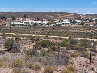
Soebatsfontein

Last updated
Soebatsfontein
South Africa Northern Cape location map.svg
Red pog.svg
Soebatsfontein
South Africa adm location map.svg
Red pog.svg
Soebatsfontein
Coordinates: 30°07′01″S17°34′59″E / 30.117°S 17.583°E / -30.117; 17.583 Coordinates: 30°07′01″S17°34′59″E / 30.117°S 17.583°E / -30.117; 17.583
Country South Africa
Province Northern Cape
District Namakwa
Municipality Kamiesberg
Area
[1]
  Total0.42 km2 (0.16 sq mi)
Population
 (2011) [1]
  Total276
  Density660/km2 (1,700/sq mi)
Racial makeup (2011)
[1]
   Coloured 97.8%
   Indian/Asian 0.4%
   White 1.8%
First languages (2011)
[1]
   Afrikaans 96.4%
   Tswana 1.8%
  Other1.8%
Time zone UTC+2 (SAST)
PO box
8257

Soebatsfontein is a settlement in Namakwa District Municipality in the Northern Cape province of South Africa.

Namakwa District Municipality District municipality in Northern Cape, South Africa

Namakwa is one of the 5 districts of the Northern Cape province of South Africa. The seat of Namakwa is Springbok and the region is also known as Little Namaqualand. The majority of its 108,118 people speak Afrikaans. The district code is DC6.

Northern Cape Province of South Africa

The Northern Cape is the largest and most sparsely populated province of South Africa. It was created in 1994 when the Cape Province was split up. Its capital is Kimberley. It includes the Kalahari Gemsbok National Park, part of the Kgalagadi Transfrontier Park, an international park shared with Botswana. It also includes the Augrabies Falls and the diamond mining regions in Kimberley and Alexander Bay. The Namaqualand region in the west is famous for its Namaqualand daisies. The southern towns of De Aar and Colesberg, in the Great Karoo, are major transport nodes between Johannesburg, Cape Town and Port Elizabeth. In the northeast, Kuruman is known as a mission station and also for its artesian spring, the Eye of Kuruman. The Orange River flows through the province, forming the borders with the Free State in the southeast and with Namibia to the northwest. The river is also used to irrigate the many vineyards in the arid region near Upington.

South Africa Republic in the southernmost part of Africa

South Africa, officially the Republic of South Africa (RSA), is the southernmost country in Africa. It is bounded to the south by 2,798 kilometres (1,739 mi) of coastline of Southern Africa stretching along the South Atlantic and Indian Oceans; to the north by the neighbouring countries of Namibia, Botswana, and Zimbabwe; and to the east and northeast by Mozambique and Eswatini (Swaziland); and it surrounds the enclaved country of Lesotho. South Africa is the largest country in Southern Africa and the 25th-largest country in the world by land area and, with over 57 million people, is the world's 24th-most populous nation. It is the southernmost country on the mainland of the Old World or the Eastern Hemisphere. About 80 percent of South Africans are of Bantu ancestry, divided among a variety of ethnic groups speaking different African languages, nine of which have official status. The remaining population consists of Africa's largest communities of European, Asian (Indian), and multiracial (Coloured) ancestry.

Settlement 80 km south-west of Springbok and 48 km north-west of Kamieskroon. The name, Afrikaans for ‘begging or pleading fountain’, dates from an incident about 1898 in which Hendrik S(t)ievert, a farmhand, was murdered by San in spite of his begging for mercy. [2]

Springbok, Northern Cape Place in Northern Cape, South Africa

Springbok is the largest town in the Namaqualand area in the Northern Cape province of South Africa. It was called Springbokfontein, until 1911, when it was shortened to Springbok. Springbok is located on the N7 national route which connects the Cape with Namibia, and at the western end of the N14, which connects it with Upington and Pretoria. It is the main town of the Nama Khoi Local Municipality, which also includes a number of surrounding towns such as Okiep and Nababeep.

Kamieskroon Place in Northern Cape, South Africa

Kamieskroon is a small town in the Kamiesberg Local Municipality, lying in the foothills of the Kamiesberge at an elevation of approximately 800 m. The town is more or less in the centre of Namaqualand, about 70 km to the south of Springbok, Northern Cape, South Africa. It is known mainly for its abundance of wild flowers during spring.

Related Research Articles

Soshanguve Place in Gauteng, South Africa

Soshanguve is a township situated about 30 km north of Pretoria, Gauteng, South Africa. The name Soshanguve is an acronym for SOtho, SHAngaan, NGUni and VEnda, thus showing the multi-ethnic composition of the population (Mashabela 1988:138). The major African languages of South Africa are heard in Soshanguve.

Aberdeen, Eastern Cape Place in Eastern Cape, South Africa

Aberdeen is a small town in the Sarah Baartman District Municipality of the Eastern Cape province of South Africa. With its numerous examples of Victorian architecture, it is one of the architectural conservation areas of the Karoo.

Gouda, Western Cape Place in Western Cape, South Africa

Gouda is a settlement in Cape Winelands District Municipality in the Western Cape province of South Africa.

Dwarskersbos Place in Western Cape, South Africa

Dwarskersbos is a settlement in West Coast District Municipality in the Western Cape province of South Africa.

Hopefield, Western Cape Place in Western Cape, South Africa

Hopefield is a settlement in West Coast District Municipality in the Western Cape province of South Africa on the R45 between Malmesbury and Vredenburg.The town is east of Saldanha Bay and Langebaan, 40 km southeast of Vredenburg and 120 km north of Cape Town.

Koringberg Place in Western Cape, South Africa

Koringberg is a settlement in West Coast District Municipality in the Western Cape province of South Africa.

Lutzville Place in Western Cape, South Africa

Lutzville is a settlement in West Coast District Municipality in the Western Cape province of South Africa. It resides under the Matzikama Local Municipality.

Haarlem, Western Cape Place in Western Cape, South Africa

Haarlem is a settlement in Garden Route District Municipality in the Western Cape province of South Africa.

Herbertsdale Place in Western Cape, South Africa

Herbertsdale is a settlement in Garden Route District Municipality in the Western Cape province of South Africa.

Herolds Bay Place in Western Cape, South Africa

Herolds Bay is a settlement in Garden Route District Municipality in the Western Cape province of South Africa.

Steytlerville Place in Eastern Cape, South Africa

Steytlerville is a settlement in Sarah Baartman District Municipality in the Eastern Cape province of South Africa.

Hendrina Place in Mpumalanga, South Africa

Hendrina is a settlement in Nkangala District Municipality in the Mpumalanga province of South Africa. It was named after Hendrien. Town is 53km north-west of Ermelo, 40km west-south-west of Carolina and 53km south-east of Middelburg.

Komaggas Place in Northern Cape, South Africa

Komaggas is a town in Namakwa District Municipality in the Northern Cape province of South Africa.

Trichardt Place in Mpumalanga, South Africa

Trichardt is a town in Gert Sibande District Municipality in the Mpumalanga province of South Africa. The village 34km west of Bethal and 32km west-south-west of Leandra, next door to Secunda.

Slurry, North West Place in North West, South Africa

Slurry is a settlement in Ngaka Modiri Molema District Municipality in the North West province of South Africa.

Nuwerus Place in Western Cape, South Africa

Nuwerus is a settlement in Matzikama Municipality, West Coast District in the Western Cape province of South Africa.

Van Stadensrus Place in Free State, South Africa

Van Stadensrus is a settlement in Naledi Municipality, falling under Xhariep District Municipality in the Free State province of South Africa.

Mhlangeni Place in Eastern Cape, South Africa

Mhlangeni is a settlement in Amathole District Municipality in the Eastern Cape province of South Africa.

Debe Nek Place in Eastern Cape, South Africa

Debe Nek is a town in Amahlathi Local Municipality in the Eastern Cape province of South Africa.

References

  1. 1 2 3 4 "Main Place Soebatsfontein". Census 2011.
  2. "Dictionary of Southern African Place Names (Public Domain)". Human Science Research Council. p. 409.