Kuboes | |
|---|---|
 Old mission church in Kuboes | |
 Kuboes  Kuboes | |
| Coordinates: 28°26′49.2″S16°59′20.76″E / 28.447000°S 16.9891000°E Coordinates: 28°26′49.2″S16°59′20.76″E / 28.447000°S 16.9891000°E | |
| Country | South Africa |
| Province | Northern Cape |
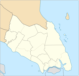
| District | Namakwa |
| Municipality | Richtersveld |
| Area | |
| • Total | 0.88 km2 (0.34 sq mi) |
| Population (2011) [1] | |
| • Total | 948 |
| • Density | 1,100/km2 (2,800/sq mi) |
| Racial makeup (2011) | |
| • Black African | 0.6% |
| • Coloured | 95.5% |
| • Indian/Asian | 0.2% |
| • Other | 3.7% |
| First languages (2011) | |
| • Afrikaans | 96.5% |
| • English | 1.3% |
| • Other | 2.2% |
| Time zone | UTC+2 (SAST) |
| PO box | 8292 |
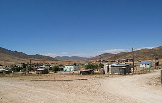
Kuboes is a town in Richtersveld Local Municipality in the Northern Cape province of South Africa.
Richtersveld is an administrative area in the Namakwa District of Northern Cape in South Africa.

The Northern Cape is the largest and most sparsely populated province of South Africa. It was created in 1994 when the Cape Province was split up. Its capital is Kimberley. It includes the Kalahari Gemsbok National Park, part of the Kgalagadi Transfrontier Park, an international park shared with Botswana. It also includes the Augrabies Falls and the diamond mining regions in Kimberley and Alexander Bay. The Namaqualand region in the west is famous for its Namaqualand daisies. The southern towns of De Aar and Colesberg, in the Great Karoo, are major transport nodes between Johannesburg, Cape Town and Port Elizabeth. In the northeast, Kuruman is known as a mission station and also for its artesian spring, the Eye of Kuruman. The Orange River flows through the province, forming the borders with the Free State in the southeast and with Namibia to the northwest. The river is also used to irrigate the many vineyards in the arid region near Upington.

South Africa, officially the Republic of South Africa (RSA), is the southernmost country in Africa. It is bounded to the south by 2,798 kilometres (1,739 mi) of coastline of Southern Africa stretching along the South Atlantic and Indian Oceans; to the north by the neighbouring countries of Namibia, Botswana, and Zimbabwe; and to the east and northeast by Mozambique and Eswatini (Swaziland); and it surrounds the enclaved country of Lesotho. South Africa is the largest country in Southern Africa and the 25th-largest country in the world by land area and, with over 57 million people, is the world's 24th-most populous nation. It is the southernmost country on the mainland of the Old World or the Eastern Hemisphere. About 80 percent of South Africans are of Sub-Saharan African ancestry, divided among a variety of ethnic groups speaking different African languages, nine of which have official status. The remaining population consists of Africa's largest communities of European (White), Asian (Indian), and multiracial (Coloured) ancestry.
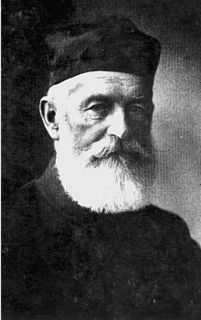
Kuboes was one of the first permanent settlements on the Richtersveld. The town grew around a Rhenish mission set up by revered Johan Hein, who began to preach to the nomadic population of the surrounding areas in 1844. A church was built in 1893, and eventually the itinerant population decided to set up in Kuboes itself. [2]
The Rhenish Missionary Society was one of the largest missionary societies in Germany. Formed from smaller missions founded as far back as 1799, the Society was amalgamated on 23 September 1828, and its first missionaries were ordained and sent off to South Africa by the end of the year.
Kuboes is a centre of Nama culture, and the local school is claimed to be the only school in the world that teaches the Nama language. [2]

Nama are an African ethnic group of South Africa, Namibia and Botswana. They traditionally speak the Nama language of the Khoe-Kwadi language family, although many Nama also speak Afrikaans. The Nama are the largest group of the Khoikhoi people, most of whom have largely disappeared as a group, except for the Namas. Many of the Nama clans live in Central Namibia and the other smaller groups live in Namaqualand, which today straddles the Namibian border with South Africa.