Nieuwoudtville

Last updated

Nieuwoudtville
Dutch Reformed Church. Nieuwoudtville, Northern Cape.JPG
Dutch Reformed Church
South Africa Northern Cape location map.svg
Red pog.svg
Nieuwoudtville
South Africa adm location map.svg
Red pog.svg
Nieuwoudtville
Coordinates: 31°22′S19°6′E / 31.367°S 19.100°E / -31.367; 19.100 Coordinates: 31°22′S19°6′E / 31.367°S 19.100°E / -31.367; 19.100
Country South Africa
Province Northern Cape
District Namakwa
Municipality Hantam
Area
[1]
  Total26.26 km2 (10.14 sq mi)
Population
 (2011) [1]
  Total2,093
  Density80/km2 (210/sq mi)
Racial makeup (2011)
[1]
   Black African 9.0%
   Coloured 80.6%
   Indian/Asian 1.6%
   White 8.2%
  Other0.6%
First languages (2011)
[1]
   Afrikaans 2%
   English 3.1%
  Other1.8%
Time zone UTC+2 (SAST)
Postal code (street)
8181
PO box
8180
Area code 027

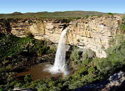
Nieuwoudtville is a town in Namakwa District Municipality in the Northern Cape province of South Africa. The town lies on the Bokkeveld Escarpment, and was established in 1897. The Nieuwoudtville Falls on the Doring River are located a few kilometres north of the town. [2]

Nieuwoudtville is in the Succulent Karroo Biome, which has less than 200 mm rainfall in winter and is even more arid in summer. However the region about this community is an oasis in the Biome, with the Doring River falling off the escarpment nearby.

Nieuwoudtville is a popular tourist destination in South Africa, especially during the wild flower season, because of its unique placement in the Karoo. The Karoo plain is known as the Bokkeveld and has a reputation as the bulb capital of the world. During spring geophytes, also known as bulbs, bloom in the area around the town. The bulbs are very rain dependent. There is also a bulb nursery where you can pick up your own bulbs to plant back at home.

Other than the bulb flower season, there are a wide variety of attractions in Nieuwoudtville such as a waterfall just outside the town, a quiver tree forest, local sandstone ruins, glacial pavement, the Oorlogskloof Nature Reserve and a myriad activities that include bird watching, hiking and a star gazing. [3]

Related Research Articles

<span class="mw-page-title-main">Geography of South Africa</span> Overview of the geography of South Africa

South Africa occupies the southern tip of Africa, its coastline stretching more than 2,850 kilometres from the desert border with Namibia on the Atlantic (western) coast southwards around the tip of Africa and then northeast to the border with Mozambique on the Indian Ocean. The low-lying coastal zone is narrow for much of that distance, soon giving way to a mountainous escarpment that separates the coast from the high inland plateau. In some places, notably the province of KwaZulu-Natal in the east, a greater distance separates the coast from the escarpment. Although much of the country is classified as semi-arid, it has considerable variation in climate as well as topography. The total land area is 1,220,813 km2 (471,359 sq mi). It has the 23rd largest Exclusive Economic Zone of 1,535,538 km2 (592,875 sq mi).

<span class="mw-page-title-main">Fynbos</span> Shrubland and heathland ecoregion of southwestern South Africa

Fynbos is a small belt of natural shrubland or heathland vegetation located in the Western Cape and Eastern Cape provinces of South Africa. This area is predominantly coastal and mountainous, with a Mediterranean climate and rainy winters. The fynbos ecoregion is within the Mediterranean forests, woodlands, and scrub biome. In fields related to biogeography, fynbos is known for its exceptional degree of biodiversity and endemism, consisting of about 80% species of the Cape floral kingdom, where nearly 6,000 of them are endemic. This land continues to face severe human-caused threats, but due to the many economic uses of the fynbos, conservation efforts are being made to help restore it.

<span class="mw-page-title-main">Karoo</span> Semi-desert region in South Africa

The Karoo is a semi-desert natural region of South Africa. No exact definition of what constitutes the Karoo is available, so its extent is also not precisely defined. The Karoo is partly defined by its topography, geology and climate, and above all, its low rainfall, arid air, cloudless skies, and extremes of heat and cold. The Karoo also hosted a well-preserved ecosystem hundreds of million years ago which is now represented by many fossils.

<span class="mw-page-title-main">Amathole Mountains</span> Mountain range in South Africa

Amatola, Amatole or Amathole are a range of densely forested mountains, situated in the Eastern Cape province of South Africa. The word Amathole means ‘calves’ in Xhosa, and Amathole District Municipality, which lies to the south, is named after these mountains.

<span class="mw-page-title-main">Karoo National Park</span> Wildlife reserve in the Great Karoo area of the Western Cape, South Africa near Beaufort West

The Karoo National Park, founded in 1979, is a wildlife reserve in the Great Karoo area of the Western Cape, South Africa near Beaufort West. This semi-desert area covers an area of 750 square kilometres (290 sq mi). The Nuweveld portion of the Great Escarpment runs through the Park. It is therefore partly in the Lower Karoo, at about 850 m above sea level, and partly in the Upper Karoo at over 1300 m altitude.

<span class="mw-page-title-main">Cape Fold Belt</span> Late Paleozoic fold and thrust belt in southwestern South Africa

The Cape Fold Belt is a fold and thrust belt of late Paleozoic age, which affected the sequence of sedimentary rock layers of the Cape Supergroup in the southwestern corner of South Africa. It was originally continuous with the Ventana Mountains near Bahía Blanca in Argentina, the Pensacola Mountains, the Ellsworth Mountains and the Hunter-Bowen orogeny in eastern Australia. The rocks involved are generally sandstones and shales, with the shales persisting in the valley floors while the erosion resistant sandstones form the parallel ranges, the Cape Fold Mountains, which reach a maximum height of 2325 m at Seweweekspoortpiek.

<span class="mw-page-title-main">Sneeuberge</span> Mountain range near Nieu-Bethesda, Eastern Cape, South Africa

The Sneeuberge or Sneeuberg mountain range was historically known as “Sneeuwbergen”, meaning ‘snow mountains’ in Cape Dutch, and refers to a significant portion of Southern Africa's Great Escarpment in the Cradock, Murraysburg, Richmond, Graaff-Reinet, Nieu-Bethesda and Middelburg districts of the Great Karoo, most of which are in the Eastern Cape Province.

<span class="mw-page-title-main">Kouebokkeveld Mountains</span> Mountain range in Western Cape, South Africa

The Koue Bokkeveld, meaning "Cold Buck Shrubland" in Afrikaans, is a mountain range in the Western Cape Province, South Africa. Geologically the range is composed of Cedarberg Sandstone of the Cape System.

<i>Haemanthus barkerae</i> Species of flowering plant

Haemanthus barkerae is a South African bulbous geophyte in the genus Haemanthus. H. barkerae is found in the Western Cape from the Bokkeveld Mountains near Nieuwoudtville and the foothills of the Roggeveld Mountains, to the Hantamsberg near Calvinia, and bounded to the north and south by Loeriesfontein and the Tanqua Karoo.

<span class="mw-page-title-main">Namaqua National Park</span> South African national park in Namaqualand in the Northern Cape

Namaqua National Park is a South African national park situated approximately 495 km north of Cape Town and 22 km northwest of Kamieskroon. It has an area of more than 1300 km2. The park is part of Namaqualand, an area covering 55,000 km2 located within the semi-desert Succulent Karoo biome. This biome is a biodiversity hotspot with the largest concentration of succulent plants in the world. The park also has an arid environment with succulent plants. The park was created to protect its flowers. During the spring, wildflowers bloom there in a spectacular fashion. The park's main tourist attraction is this abundant spring bloom of brightly coloured wildflowers.

<span class="mw-page-title-main">Renosterveld</span> Vegetation type and plant community of the Cape Floristic Region

Renosterveld is a term used for one of the major plant communities and vegetation types of the Cape Floristic Region which is located in southwestern and southeastern South Africa, in southernmost Africa. It is an ecoregion of the Mediterranean forests, woodlands, and scrub biome.

<span class="mw-page-title-main">Hantam National Botanical Garden</span> Botanical Garden just outside Nieuwoudtville in the Northern Cape, South Africa

Situated just outside Nieuwoudtville, the Hantam National Botanical Garden is the youngest of South Africa's nine National Botanical Gardens and the first National Botanical Garden in the Northern Cape, South Africa.

<i>Brunsvigia bosmaniae</i> Species of flowering plant

Brunsvigia bosmaniae is a South African geophyte belonging to the family Amaryllidaceae, and occurring along the dry west coast of the Cape Province. It is known for its profuse pink flowers, usually in March, a few weeks after late summer rains.

<i>Romulea sabulosa</i> Species of flowering plant

Romulea sabulosa is a perennial geophyte that is assigned to the family Iridaceae. It has a few grooved thread-like leaves, and relatively large burgundy red trimerous flowers, reminiscent of crocus flowers, with yellow to light greenish with black markings and stamens with light green free filaments. It only occurs on sandy clay on renosterveld west of Nieuwoudtville in the Northern Cape province South Africa. It is called satynblom in Afrikaans.

<i>Romulea monadelpha</i> Species of plant

Romulea monadelpha is a herbaceous perennial geophyte in the family Iridaceae native to South Africa. It has a small corm in the soil, a few thread-like leaves, and trimerous dark red flowers with elaborate markings on the inside near the bottom of the flower. It is called karoo satynblom in Afrikaans.

The Oorlogskloof Nature Reserve, covering 4,776 hectares, is located 10 km south of Nieuwoudtville in the Northern Cape, South Africa. The Oorlogskloof River runs along the eastern border of the reserve, while the western part is bordered by the Knersvlakte. Streams dissect the mountainous terrain, resulting in gorges, 36 natural pools and waterfalls found throughout the reserve. There are also examples of rock art in caves beside some of the plateaus of the reserve. There are a couple of day and overnight trails, totalling 146 km in length, with 10 log cabins.

<i>Leucadendron brunioides <span style="font-style:normal;">var.</span> brunioides</i> Variety of plant

Leucadendron brunioides var. brunioides, the common foetid conebush, is a flower-bearing shrub and variety of Leucadendron brunioides, which belongs to the genus Leucadendron and forms part of the fynbos. The plant is native to the Western Cape where it occurs on the Bokkeveld Carp near Nieuwoudtville, the Sandveld, Gifberg, Cederberg to the eastern Koue Bokkeveld, Hex River Mountains, and the Breede River Valley.

<i>Zantedeschia odorata</i> Species of flowering plant

Zantedeschia odorata, the Bokkeveld arum, is a species in the arum family, Araceae. It is a tuberous, perennial plant that grows to a height of 75 to 100 cm. The flowers are yellow, have long narrow veins and are enclosed by a white leathery bract. The leaves are arrow-shaped. The plant grows in wetlands or along streams. The plant is rare and indigenous to the Northern Cape where it occurs on the Bokkeveld escarpment near Nieuwoudtville.

<i>Babiana vanzijliae</i> Species of flowering plant

Babiana vanzijliae is a species of geophyte of 4–12 cm (1.6–4.7 in) high that is assigned to the family Iridaceae. It has leaves that consist of a sheath and a blade that are at an angle with each other. The leaf blades are narrow, sword- to lance-shaped and have a left and right surface, rather than an upper and lower surface. The leaf blades are pleated and covered in velvety hairs. The inflorescence contains three to five pale bluish mauve to yellow flowers, but the lower lateral tepals are yellow becoming pale around the edges, and with three stamens crowding under the upper lip. Flowering occurs from early August to the middle of September. The flowers emit a strong scent. B. vanzijliae grows along the Bokkeveld Escarpment near Nieuwoudtville in the Northern Cape province of South Africa.

References

  1. 1 2 3 4 "Main Place Nieuwoudtville". Census 2011.
  2. "Nieuwoudtville Information". Wheretostay. Retrieved 26 August 2013.
  3. "Nieuwoudtville".