
South Africa occupies the southern tip of Africa, its coastline stretching more than 2,850 kilometres from the desert border with Namibia on the Atlantic (western) coast southwards around the tip of Africa and then northeast to the border with Mozambique on the Indian Ocean. The low-lying coastal zone is narrow for much of that distance, soon giving way to a mountainous escarpment that separates the coast from the high inland plateau. In some places, notably the province of KwaZulu-Natal in the east, a greater distance separates the coast from the escarpment. Although most of the country is classified as semi-arid, it has considerable variation in climate as well as topography. The total land area is 1,220,813 km2 (471,359 sq mi). It has the 23rd largest Exclusive Economic Zone of 1,535,538 km2 (592,875 sq mi).

Calumet is a village in Calumet Township, Houghton County, in the U.S. state of Michigan's Upper Peninsula, that was once at the center of the mining industry of the Upper Peninsula. Also known as Red Jacket, the village includes the Calumet Downtown Historic District, listed on the National Register of Historic Places (NRHP). The village may itself be included within the Calumet Historic District, a larger area which is NRHP-listed and which is a National Historic Landmark District. It is bordered on the north by Calumet Township, on the south by the unincorporated towns of Newtown and Blue Jacket, on the east by Blue Jacket and Calumet Township, and on the west by Yellow Jacket and Calumet Township. The population was 726 at the 2010 census. Calumet's nickname is Copper Town U.S.A.
Copperopolis is an unincorporated town and census-designated place (CDP) in Calaveras County, California, United States. The population was 3,671 at the 2010 census, up from 2,363 at the 2000 census. The town is located along State Route 4 and is registered as California Historical Landmark #296.

Musina is the northernmost town in the Limpopo province of South Africa. It is located near the confluence of the Limpopo River with the Sand River and the border to Zimbabwe. It has a population of between 20,000 and 40,000. Iron ore, coal, magnetite, graphite, asbestos, diamonds, semi-precious stones and copper are mined in the region.

Phalaborwa is a town in the Mopani District Municipality, Limpopo province, South Africa. It is located near the confluence of the Ga-Selati River and the Olifants, halfway up along the western border of the Kruger National Park in the Lowveld.
The following lists events that happened during 1898 in South Africa.

Alexander Bay is a town in the extreme north-west of South Africa. It is located on the southern bank of the Orange River mouth. It was named for Sir James Alexander, who was the first person to map the area whilst on a Royal Geographical Society expedition into Namibia in 1836. With diamonds being discovered along the West Coast in 1925, Alexander Bay was established to service the mining industry.
Mufulira, is a town in the Copperbelt Province of Zambia. Mufulira means "Place of Abundance and Peace". The town developed around the Mufulira Copper Mine in the 1930s. The town also serves as the administrative capital of Mufulira District.

Luanshya is a town in Zambia, in the Copperbelt Province near Ndola. It has a population of 117,579.

Port Nolloth is a town and small domestic seaport in the Namaqualand region on the northwestern coast of South Africa, 144 kilometres (89 mi) northwest of Springbok. It is the seat of the Richtersveld Local Municipality.

Chililabombwe is a small town in Copperbelt Province, Zambia. It is located near the Democratic Republic of the Congo border. The name Chililabombwe means 'place of the croaking frog' in the local language of Bemba. The town has a population of 87 000 based on census data from 2010, making it one of the largest towns in the Copperbelt. The city is 30km from neighbouring town of Chingola, and approximately 20km from the large border market of Kasumbalesa. It has also produced national heroes like the late soccer star Eston Mulenga and many others. It's a home for the bundu people

Springbok is the largest town in the Namaqualand area in the Northern Cape province of South Africa. It was called Springbokfontein until 1911, when it was shortened to Springbok. Springbok is located on the N7 national route which connects the Cape with Namibia, and at the western end of the N14, which connects it with Upington and Pretoria. It is the main town of the Nama Khoi Local Municipality, which also includes a number of surrounding towns such as Okiep and Nababeep.
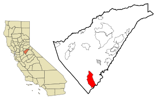
Okiep is a small town in the Northern Cape province of South Africa, and was in the 1870s ranked as having the richest copper mine in the world. The town is on the site of a spring that was known in the Khoekhoe language of the Nama people as U-gieb and was originally spelled as O'okiep.

Aggeneys is a mining town established in 1976 on a farm of that name, situated between Pofadder and Springbok in the Northern Cape, South Africa.
Concordia is a town in Namakwa District Municipality in the Northern Cape province of South Africa. The distance from Concordia to Cape Town is approximately 600 km (370 mi).

Steinkopf is a town in Namakwa District Municipality in the Northern Cape province of South Africa.
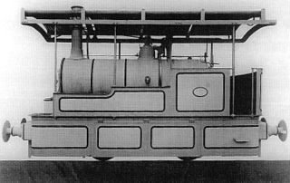
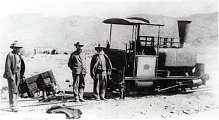
The Cape Copper Mining Company 0-4-0WT Condenser of 1886 was a South African steam locomotive from the pre-Union era in the Cape of Good Hope.
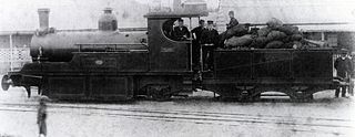
The Namaqualand 0-6-2 Clara Class of 1890 was a South African steam locomotive from the pre-Union era in the Cape of Good Hope.

The Namaqua Copper Company 0-4-2STPioneer of 1901 was a South African steam locomotive from the pre-Union era in the Cape of Good Hope.

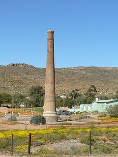
In the Colonies and Boer Republics which became the Union of South Africa in 1910, several unofficial military decorations and medals were instituted and awarded during the nineteenth and early twentieth century. The Cape Copper Company Medal for the Defence of O'okiep is a private campaign medal which was instituted by the Cape Copper Company Limited in 1902. The medal was awarded to members of the O'okiep Garrison who defended the town while it was besieged by Boer Commandos from 4 April to 4 May 1902, near the end of the Second Boer War.


