Lekkersing

Last updated
Lekkersing
South Africa Northern Cape location map.svg
Red pog.svg
Lekkersing
South Africa adm location map.svg
Red pog.svg
Lekkersing
Coordinates: 29°00′07″S17°05′49″E / 29.002°S 17.097°E / -29.002; 17.097 Coordinates: 29°00′07″S17°05′49″E / 29.002°S 17.097°E / -29.002; 17.097
Country South Africa
Province Northern Cape
District Namakwa
Municipality Richtersveld
Area
[1]
  Total0.63 km2 (0.24 sq mi)
Population
(2011) [1]
  Total363
  Density580/km2 (1,500/sq mi)
Racial makeup (2011)
[1]
   Black African 1.7%
   Coloured 97.5%
   Indian/Asian 0.6%
  Other0.3%
First languages (2011)
[1]
   Afrikaans 98.9%
  Other1.1%
Time zone UTC+2 (SAST)
Postal code (street)
8283
PO box
8283

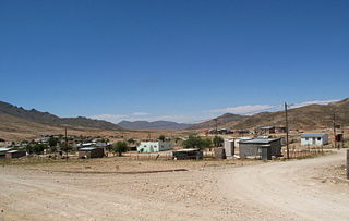
Lekkersing is a town in Namakwa District Municipality in the Northern Cape province of South Africa.

Namakwa District Municipality District municipality in Northern Cape, South Africa

Namakwa is one of the 5 districts of the Northern Cape province of South Africa. The seat of Namakwa is Springbok and the region is also known as Little Namaqualand. The majority of its 108,118 people speak Afrikaans. The district code is DC6.

Northern Cape Province of South Africa

The Northern Cape is the largest and most sparsely populated province of South Africa. It was created in 1994 when the Cape Province was split up. Its capital is Kimberley. It includes the Kalahari Gemsbok National Park, part of the Kgalagadi Transfrontier Park, an international park shared with Botswana. It also includes the Augrabies Falls and the diamond mining regions in Kimberley and Alexander Bay. The Namaqualand region in the west is famous for its Namaqualand daisies. The southern towns of De Aar and Colesberg, in the Great Karoo, are major transport nodes between Johannesburg, Cape Town and Port Elizabeth. In the northeast, Kuruman is known as a mission station and also for its artesian spring, the Eye of Kuruman. The Orange River flows through the province, forming the borders with the Free State in the southeast and with Namibia to the northwest. The river is also used to irrigate the many vineyards in the arid region near Upington.

South Africa Republic in the southernmost part of Africa

South Africa, officially the Republic of South Africa (RSA), is the southernmost country in Africa. It is bounded to the south by 2,798 kilometres (1,739 mi) of coastline of Southern Africa stretching along the South Atlantic and Indian Oceans; to the north by the neighbouring countries of Namibia, Botswana, and Zimbabwe; and to the east and northeast by Mozambique and Eswatini (Swaziland); and it surrounds the enclaved country of Lesotho. South Africa is the largest country in Southern Africa and the 25th-largest country in the world by land area and, with over 57 million people, is the world's 24th-most populous nation. It is the southernmost country on the mainland of the Old World or the Eastern Hemisphere. About 80 percent of South Africans are of Sub-Saharan African ancestry, divided among a variety of ethnic groups speaking different African languages, nine of which have official status. The remaining population consists of Africa's largest communities of European (White), Asian (Indian), and multiracial (Coloured) ancestry.

Lekkersing, located about 50km from Eksteenfontein and 70km from Kuboes, lies nestled in the hills of the Richtersveld. Temperatures as high as 53°C have been recorded in this area. [2]

Eksteenfontein Place in Northern Cape, South Africa

Eksteenfontein is a town in Namakwa District Municipality in the Northern Cape province of South Africa, on the edge of the Richtersveld World Heritage Site.

Kuboes Place in Northern Cape, South Africa

Kuboes is a town in Richtersveld Local Municipality in the Northern Cape province of South Africa.

Richtersveld

The Richtersveld is a desert landscape characterised by rugged kloofs and high mountains, situated in the north-western corner of South Africa’s Northern Cape province. It is full of changing scenery from flat, sandy, coastal plains, to craggy sharp mountains of volcanic rock and the lushness of the Orange River, which forms the border with neighboring Namibia. The area ranges in altitude from sea level, to 1,377 m (4,518 ft) at Cornellberg. Located in the north-eastern side of the Northern Cape province in South Africa, the Richtersveld is regarded as the only arid biodiversity hotspot on earth and the majority of the area is inscribed on UNESCO's World Heritage List due to its cultural values.

Related Research Articles

Kara Sea A marginal sea of the Arctic Ocean north of Siberia between Novaya Zemlya and Severnaya Zemlya

The Kara Sea is part of the Arctic Ocean north of Siberia. It is separated from the Barents Sea to the west by the Kara Strait and Novaya Zemlya, and the Laptev Sea to the east by the Severnaya Zemlya archipelago. It is named after the Kara River, which is now relatively insignificant but which played an important role in the Russian conquest of northern Siberia. The Kara River name is derived from Nenets word meaning "hummocked ice".

Massachusetts Bay A bay on the Atlantic Ocean that forms part of the central coastline of the Commonwealth of Massachusetts.

Massachusetts Bay is a bay on the Atlantic Ocean that forms part of the central coastline of the Commonwealth of Massachusetts.

Bourne, Massachusetts Town in Massachusetts, United States

Bourne is a town in Barnstable County, Massachusetts, United States. The population was 19,754 at the 2010 census.

Cape Wrath northwestern extreme point of mainland Great Britain

Cape Wrath is a cape in the Durness parish of the county of Sutherland in the Highlands of Scotland. It is the most north-westerly point in mainland Britain.

Laptev Sea Marginal sea in the Arctic Ocean north of Siberia between the Kara Sea and the East Siberian Sea

The Laptev Sea is a marginal sea of the Arctic Ocean. It is located between the northern coast of Siberia, the Taimyr Peninsula, Severnaya Zemlya and the New Siberian Islands. Its northern boundary passes from the Arctic Cape to a point with co-ordinates of 79°N and 139°E, and ends at the Anisiy Cape. The Kara Sea lies to the west, the East Siberian Sea to the east.

North Cape (Norway) cape on the island of Magerøya in Northern Norway

North Cape is a cape on the northern coast of the island of Magerøya in Northern Norway. The cape is in Nordkapp Municipality in Finnmark county, Norway. The European route E69 highway has its northern terminus at North Cape, which makes it the northernmost point in Europe that can be accessed by car and makes the E69 the northernmost public road in Europe. The plateau is a popular tourist attraction. The cape includes a 307-metre-high cliff (1,007 ft) with a large flat plateau on top, where visitors, weather permitting, can watch the midnight sun and views of the Barents Sea to the north. North Cape Hall, a visitor centre, was built in 1988 on the plateau. It includes a café, restaurant, post office, souvenir shop, a small museum, and video cinema.

Dennistoun Glacier glacier in Antarctica

The Dennistoun Glacier is a glacier, 50 nautical miles long, draining the northern slopes of Mounts Black Prince, Royalist and Adam in the Admiralty Mountains of Victoria Land in Antarctica. It flows northwest between the Lyttelton Range and Dunedin Range, turning east on rounding the latter range to enter the sea south of Cape Scott. The coastal extremity of the glacier was charted in 1911–12 by the Northern Party, led by Victor Campbell, of the British Antarctic Expedition, 1910–13. The geographical feature lies situated on the Pennell Coast, a portion of Antarctica lying between Cape Williams and Cape Adare.

Nantucket Sound A roughly triangular area of the Atlantic Ocean offshore from the U.S. state of Massachusetts

Nantucket Sound is a roughly triangular area of the Atlantic Ocean offshore from the U.S. state of Massachusetts. It is 30 miles (48 km) long and 25 miles (40 km) wide, and is enclosed by Cape Cod on the north, Nantucket on the south, and Martha's Vineyard on the west. Between Cape Cod and Martha's Vineyard it is connected to the Vineyard Sound. Ports on Nantucket Sound include Nantucket and Hyannis, Massachusetts.

White Island (Nunavut) island in Canada

White Island is one of the uninhabited Canadian arctic islands in Kivalliq Region, Nunavut, Canada. Located in Foxe Basin off the northern tip of Southampton Island, it measures 789 km2 (305 sq mi) in area.

Lincoln Sea A part of the Arctic Ocean from Cape Columbia, Canada, in the west to Cape Morris Jesup, Greenland, in the east

Lincoln Sea is a body of water in the Arctic Ocean, stretching from Cape Columbia, Canada, in the west to Cape Morris Jesup, Greenland, in the east. The northern limit is defined as the great circle line between those two headlands. It is covered with sea ice throughout the year, the thickest sea ice in the Arctic Ocean, which can be up to 15 m (49 ft) thick. Water depths range from 100 m (330 ft) to 300 m (980 ft). Water and ice from Lincoln Sea empty into Robeson Channel, the northernmost part of Nares Strait, most of the time.

Great Northern Peninsula peninsula

The Great Northern Peninsula is the largest and longest peninsula of Newfoundland, Canada, approximately 225 km long and 80 km wide at its widest point and encompassing an area of 17,483 km². It is defined as that part of Newfoundland from Bonne Bay northwards around Cape Norman and Cape Bauld and thence southwards to the head of White Bay, bounded by the Gulf of St. Lawrence on the west, the Strait of Belle Isle on the north and the Labrador Sea and White Bay on the east.

N12 (South Africa) national road in South Africa

The N12 is a national route in South Africa which runs from George through Beaufort West, Kimberley, Klerksdorp and Johannesburg to Witbank It is maintained by the South African National Roads Agency

Cape Wrath Lighthouse lighthouse located at the most North-Westerly point of the British mainland, in Sutherland, Scotland

Cape Wrath Lighthouse at Cape Wrath was built in 1828 by Robert Stevenson and was manned until 1998, when it was converted to automatic operation by the Northern Lighthouse Board. It is located at the most North-Westerly point on the British mainland, in the traditional county of Sutherland within Highland Region. Durness is the closest village, 10 miles (16 km) to the south-east with Inverness around 120 miles (190 km) to the south.

The Western Coastal Plains is a strip of coastal plain 50 kilometres (31 mi) in width between the west coast of India and the Western Ghats hills, which starts near the south of the Tapi River. The plains are located between the Western Ghats and the Arabian Sea. The plains begin at Gujarat in the north and end at Kerala in the south. It includes the states of Maharashtra, Goa and Karnataka. The region consists of three sections: the Northern part of the coast is called the Konkan (Mumbai-Goa), the central stretch is called the Kanara, while the southern stretch is referred to as the Malabar Coast. On its northern side there are two gulfs: the Gulf of Khambat and the Gulf of Kutch. The rivers along the coast form estuaries and provide conditions ideal for pisciculture. because of the presence of less coastal land in this part, it will be affected more by the global warming.

False Cape Natural Area Preserve

False Cape Natural Area Preserve is a 3,573-acre (14.46 km2) Natural Area Preserve located in Virginia Beach, Virginia, just north of the state border with North Carolina. The preserve covers a one-by-six-mile strip of largely undeveloped land located on False Cape between the Atlantic Ocean and Back Bay, and is one of the most undisturbed areas of coastal habitat remaining in the Mid-Atlantic.

Cape Chidley Islands

The Cape Chidley Islands are members of the Canadian Arctic Archipelago in the territory of Nunavut. They are located in the Labrador Sea at the south end of the entrance to the Hudson Strait, north of Killiniq Island's Cape Chidley, and separated from Killiniq Island by the MacGregor Strait.

Kenhardt Place in Northern Cape, South Africa

Kenhardt is a small town in the Northern Cape province of South Africa. This little town is about 120 km from Upington, the largest town in the area.

Dorset Island island in Nunavut, Canada

Dorset Island or Cape Dorset Island is one of the Canadian Arctic islands located in Hudson Strait, Nunavut, Canada. It lies off the Foxe Peninsula area of southwestern Baffin Island in the Qikiqtaaluk Region. It is serviced by an airport and a harbour.

Nuussuup Nuua is a cape in the Qaasuitsup municipality in northwestern Greenland.

References

  1. 1 2 3 4 "Main Place Lekkersing". Census 2011.
  2. "Lekkersing, Northern Cape". SA Travel Directory. Retrieved 4 January 2014.