Great Brickhill is a village and civil parish in the unitary authority area of Buckinghamshire, England. It is on the border with the City of Milton Keynes, located 6 miles (9.7 km) south-east of Central Milton Keynes, and 3 miles (4.8 km) in the same direction from Fenny Stratford.
Exton is a small village and civil parish in the City of Winchester district of Hampshire, England. The village lies in the South Downs National Park, on the west bank of the River Meon, immediately to the north of Corhampton. It is located two miles north of Droxford and five miles north-east of Bishop's Waltham. Its name first appears in 940 as East Seaxnatune, meaning "farmstead of the East Saxons".

Whitwell is a village and civil parish in the county of Rutland in the East Midlands of England. The population at the 2001 census was 41. At the 2011 census the population remained less than 100 and was included together with the neighbouring parish of Exton.

Ashwell is a village and civil parish in the county of Rutland in the East Midlands of England. It is about 3 miles (5 km) north of Oakham.

Burley, or Burley-on-the-Hill, is a village and civil parish in the county of Rutland in the East Midlands of England. It is two miles (3 km) north-east of Oakham. The population of the civil parish was 577 at the 2001 census, including Egleton, but reducing to 325 at the 2011 census.
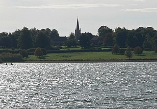
Edith Weston is a village and civil parish in the county of Rutland in the East Midlands of England. The population of the civil parish was 1,042 at the 2001 census, including Normanton and increasing to 1,359 at the 2011 census. It is on the south-eastern shore of Rutland Water and is home of the main sailing club and a fishing lodge. The village is named after Edith of Wessex (1029–1075), the queen of Edward the Confessor and sister of Harold Godwinson.

Empingham is a village in the county of Rutland in the East Midlands of England. The population of the civil parish was 815 at the 2001 census including Horn and increasing to 880 at the 2011 census. It lies close to the dam of Rutland Water and the A606 runs through the village. During construction, Empingham Reservoir was the name of the reservoir but it was renamed Rutland Water to preserve the name of the county which was being merged with Leicestershire.

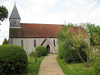
Exton is a village and former civil parish, now in the parish of Exton and Horn, in the county of Rutland, England. The population of the parish was 607 at the 2011 census. On 1 April 2016 the parish was abolished and merged with Horn to form "Exton and Horn".
Manton is a village in the county of Rutland in the East Midlands of England. It lies south-west of Rutland Water. The population of the civil parish at the 2001 census was 364, and after including Gunthorpe decreased slightly to 359 at the 2011 census.

Tinwell is a village and civil parish in the county of Rutland in the East Midlands of England. The population at the 2001 census was 209, increasing to 234 at the 2011 census.

Knaptoft is a deserted medieval village and civil parish in the Harborough district of Leicestershire and lies approximately 9.7 miles (15.6 km) south of the city of Leicester, England. According to the University of Nottingham English Place-names project, the settlement name Knaptoft could mean "cnafa" for 'a boy, a young man, a servant, a menial, or a personal name' and 'toft', the plot of ground in which a dwelling stands. The population of the civil parish at the 2011 census was 47.

Elmesthorpe is a village and civil parish in the Blaby district of Leicestershire, England. It is situated to the south-east of Earl Shilton, near to Hinckley on the A47 road. In 2004, the parish had an estimated population of 520, reducing to 509 at the 2011 census.

Stockerston is a village and civil parish in the Harborough district of Leicestershire, England, located on the border with Rutland, by the Eye Brook. According to the 2001 census the parish had a population of 35. The population remained less than 100 at the 2011 census and is included in the civil parish of Horninghold.

Mells is a village and civil parish in Somerset, England, near the town of Frome.

Wardley is a village and civil parish in the county of Rutland in the East Midlands of England. The population at the 2001 census was 32. At the 2011 census the population remained less than 100 and is included in the civil parish of Ridlington. It is located about two miles (3 km) west of Uppingham, close to the A47.

Exton is a village and civil parish 5 miles (8 km) north-east of Dulverton and 9 miles (14 km) south-west of Dunster in Somerset, England. It lies on the River Exe on Exmoor. The parish includes the village of Bridgetown and covers 2,017 ha, all of which is within the national park.

Duddington is a village and former civil parish, now in the parish of Duddington-with-Fineshade, in the North Northamptonshire district, in the ceremonial county of Northamptonshire, England. It is by the junction of the A47 and A43 roads, and is 9 kilometres (6 mi) southwest of the town of Stamford. The village is on the east bank of the River Welland which is the county boundary of Rutland. In 1961 the parish had a population of 184.

Rutland is a ceremonial county in the East Midlands of England. It borders Leicestershire to the north and west, Lincolnshire to the north-east, and Northamptonshire to the south-west. Oakham is the largest town and county town.

Little Faringdon is a village and civil parish in West Oxfordshire, about 1 mile (1.6 km) north of Lechlade in neighbouring Gloucestershire. The 2001 Census recorded its population as 63.
Exton and Horn is a civil parish in Rutland, England, formed in 2016 upon the merger of the historic parishes of Exton and Horn.

