Hosakote, Kodagu

Last updated

Hosakote, Kodagu

Hosakote
village
India Karnataka location map.svg
Red pog.svg
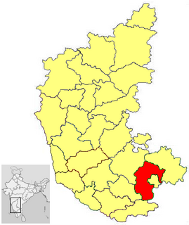
Hosakote, Kodagu
Location in Karnataka, India
India location map.svg
Red pog.svg
Hosakote, Kodagu
Hosakote, Kodagu (India)
Coordinates: 12°25′27″N75°52′02″E / 12.4243000°N 75.867317°E / 12.4243000; 75.867317 Coordinates: 12°25′27″N75°52′02″E / 12.4243000°N 75.867317°E / 12.4243000; 75.867317
CountryFlag of India.svg  India
State Karnataka
District Kodagu
Talukas Somavarapete
Government
  BodyVillage Panchayat
Languages
  Official Kannada
Time zone UTC+5:30 (IST)
Nearest cityKodagu
Civic agencyVillage Panchayat

Hosakote is a village in the southern state of Karnataka, India. [1] [2] It is located in the Somavarapete taluk of Kodagu district in Karnataka.

Karnataka State in southern India

Karnataka is a state in the south western region of India. It was formed on 1 November 1956, with the passage of the States Reorganisation Act. Originally known as the State of Mysore, it was renamed Karnataka in 1973. The state corresponds to the Carnatic region. The capital and largest city is Bangalore (Bengaluru).

India Country in South Asia

India, also known as the Republic of India, is a country in South Asia. It is the seventh largest country by area and with more than 1.3 billion people, it is the second most populous country as well as the most populous democracy in the world. Bounded by the Indian Ocean on the south, the Arabian Sea on the southwest, and the Bay of Bengal on the southeast, it shares land borders with Pakistan to the west; China, Nepal, and Bhutan to the northeast; and Bangladesh and Myanmar to the east. In the Indian Ocean, India is in the vicinity of Sri Lanka and the Maldives, while its Andaman and Nicobar Islands share a maritime border with Thailand and Indonesia.

Kodagu district District in Karnataka, India

Kodagu is an administrative district in Karnataka, India. Before 1956, it was an administratively separate Coorg State, at which point it was merged into an enlarged Mysore State. It occupies an area of 4,102 square kilometres (1,584 sq mi) in the Western Ghats of southwestern Karnataka. In 2001 its population was 548,561, 13.74% of which resided in the district's urban centres, making it the least populous of the 30 districts in Karnataka.

Contents

See also

Related Research Articles

Badagabanangala is a village in the southern state of Karnataka, India. It is located in the Virajpet taluk of Kodagu district in Karnataka.

Bidarur village in Karnataka, India

Bidarur is a village in the southern state of Karnataka, India. It is located in the Somvarpet taluk of Kodagu district.

Channayan Kote village in Karnataka, India

Channayan Kote is a village in the southern state of Karnataka, India. It is located in the Virajpet taluk of Kodagu district.

Choudlu is a village in the southern state of Karnataka, India. It is located in the Somvarpet taluk of Kodagu district.

Halligattu village in Karnataka, India

Halligattu is a village in the southern state of Karnataka, India. It is located in the Virajpet taluk of Kodagu district.

Kaikeri is a village in the southern state of Karnataka, India. It is located in the Virajpet taluk of Kodagu district.

Kudige is a village in the southern state of Karnataka, India. It is located in the Somvarpet taluk of Kodagu district in Karnataka.

Kudumangalore is a village in the southern state of Karnataka, India. It is located in the Somvarpet taluk of Kodagu district.

Mullusoge is a village in the southern state of Karnataka, India. It is located in the Somvarpet taluk of Kodagu district.

Nelliyahadikeri is a village in the southern state of Karnataka, India. It is located in the Somvarpet taluk of Kodagu district.

Ulugulli is a village in the southern state of Karnataka, India. It is located in the Somvarpet taluk of Kodagu district.

Y.N. Hosakote town in Karnataka, India

Yallappa Nayakana Hosakote, often written as Y. N. Hosakote is a small town in the southern state of Karnataka, India. It is located in the Pavagada taluk of Tumkur district in Karnataka. In 1556 a local king named Yallappa nayaka founded the fort on the hill Siddarabetta beside of Kundurpi. This place gate name as Yallappanayakana hosakote.

Sulibele village in Karnataka, India

Sulibele is a village in the southern state of Karnataka, India. It is located in the Hosakote taluk of Bangalore Rural district.

Abbimatta is a village in the southern state of Karnataka, India. It is located in the Somvarpet taluk of Kodagu district.

Abyathamangala is a village in the southern state of Karnataka, India. It is located in the Somvarpet taluk of Kodagu district.

Agalli is a village in the southern state of Karnataka, India. It is located in the Somvarpet taluk of Kodagu district.

Agasarahalli (Hosakote) village in Karnataka, India

Agasarahalli is a village in the southern state of Karnataka, India. It is located in the Hosakote taluk of Bangalore Rural district in Karnataka.

Agrahara Vaddahalli village in Karnataka, India

Agrahara Vaddahalli is a village in the southern state of Karnataka, India. It is located in the Hosakote taluk of Bangalore Rural district.

Aigur village in Karnataka, India

Aigur is a village in the southern state of Karnataka, India. It is located in the Somvarpet taluk of Kodagu district.

Ajjagondahalli village in Karnataka, India

Ajjagondahalli is a village in the southern state of Karnataka, India. It is located in the Hosakote taluk of Bangalore Rural district in Karnataka.

References

  1. "Census of India : List of Villages Alphabetical Order > Karnataka". Registrar General & Census Commissioner, India. Retrieved 2008-12-18.[ permanent dead link ] , Census Village code= 2743700
  2. "Yahoo! maps India :". Archived from the original on 2008-12-18. Retrieved 2009-04-17. 7 Th Hosakote, Kodagu, Karnataka