Humboldt Wagon Road

Last updated

Approximate routes of the Humboldt Wagon Road (red) in California, and connecting roads to Silver City, Idaho and Star City, Nevada (blue) Humboldt wagon road route improved.png
Approximate routes of the Humboldt Wagon Road (red) in California, and connecting roads to Silver City, Idaho and Star City, Nevada (blue)

The Humboldt Wagon Road, or the Humboldt Road, was a freight wagon road in northern California. Constructed in the 1860s, it connected Chico, near the Sacramento River, with Susanville, near Honey Lake, east of the Sierra Nevada crest. From there, extensions continued to the Humboldt silver mines in Nevada and the Owyhee Mines near Silver City, Idaho. [1] The road was surveyed and financed by prominent settler John Bidwell and carried passengers, mail, and freight between logging and ranching communities of northeastern California. It also contributed to the settlement of the region and the displacement of the native Maidu population. Portions of the Humboldt Road are now followed by California State Route 32 and California State Route 36.

Contents

Route description

The Humboldt Road began in Chico at a site called The Junction, at the present-day intersection of 9th and Main Streets. [2] It followed Little Chico Creek eastward, then climbed into the Sierra Nevada foothills along the ridge separating the Big and Little Chico Creek drainages. It ascended the mountains, passing through the communities of Forest Ranch, Lomo, Butte Meadows, and Jonesville, then crested the "Big Summit” at 6,600 feet (2,012 m) elevation near the Butte-Plumas County line. It then merged with the Humbug Stagecoach Road from Oroville and descended to Prattville, at the Big Meadows (now Lake Almanor). From there it proceeded eastward over rolling, forested terrain, crossing into the Great Basin at Fredonyer Pass, and into Susanville. [3] At Susanville, the road connected with an existing road extending eastward into Nevada, from which it was possible to head northward to the Idaho Territory along the Idaho Stage Company's road to Ruby City. [3]

The road got its name from the mining district in Humboldt County, Nevada, a source of much of its early traffic. [4] [5] Between 1865 and 1867, it passed through portions of Butte, Tehama, Plumas, and Lassen counties. [6] [1]

Early history

In the early 1860s, deposits of silver were discovered in the Humboldt Range of Nevada and in southwest Idaho. The transit of workers and supplies between these mining districts and California was difficult, due to isolation and the lack of wagon roads and railroads: To reach California, freight either had to be hauled over the dangerous and often snowed-in passes of the high Sierra Nevada, or shipped northward by a circuitous route down the Snake and Columbia Rivers, to the Pacific Ocean and down the coast to San Francisco. [7] [8]

John Bidwell Congressman John Bidwell.jpg
John Bidwell

Almost due west of the Humboldt Mines lay the city of Chico, California, which had easy access to steamboat shipping on the Sacramento River. Chico's founder, California Representative John Bidwell, recognized that his city could function as a hub for freight traffic to and from the mines, if a road could be built directly eastward to Nevada. [9] [10] Already wealthy from successful ventures in gold mining and logging, Bidwell aligned with other California financiers and put forth some $40,000 to construct the road, and in 1863 received a franchise to operate the highway as a toll road; the group incorporated the following year as the Chico and Humboldt Wagon Road Company. Construction on the road used white, Maidu, and Chinese laborers, who generally earned around $1 per day of work. [11] Construction was complete by late 1864. [12] [13] The first tollbooth was about 14 miles (23 km) east of Chico, near modern Forest Ranch, [14] and charged $1 for a single horseman, $2 for a one-horse buggy, and $1 for each additional horse; [15] the toll was later decreased to $0.75 for a two-horse wagon. [16]

The mining boom proved short-lived, but passenger traffic via stagecoach quickly became popular on the Humboldt Road. Early attempts at stagecoach travel proved slow and dangerous, but in 1866 the newly-formed Chico and Idaho Stage and Fast Freight Company established rapid service, and by late 1866, stagecoaches could make the 400-mile (644 km) trip from Chico to Ruby City in under four days, if weather was favorable—albeit at the steep fare of $60 per passenger (equivalent to $1,256in 2022). [17] The establishment of way stations for coach lines encouraged settlement in once-remote portions of California. This increased settlement put growing pressure on the native Maidu and Yana, whose numbers were plummeting due to disease and direct persecution by white settlers. [18] [19]

Chico and Humboldt Wagon Road Company stock certificate issued to John Bidwell CHWR stock certificate.tif
Chico and Humboldt Wagon Road Company stock certificate issued to John Bidwell

After the first transcontinental railroad was completed in 1869, the Humboldt Wagon Road lost its importance as a long-distance route. It remained important as a regional highway, particularly to service the many sawmills and turpentine operations in the pine forests of Butte and Plumas Counties. [20] A summer tourism industry also sprang up along the Humboldt Road, with mountain communities such as Butte Meadows, Jonesville, and (later) Lake Almanor building facilities for vacationers seeking to escape the severe summer heat of the Central Valley. [21]

Although the Humboldt Road avoided the highest elevations of the Sierra Nevada, it was still subject to heavy winter snowfalls that could block traffic for weeks at a time. The severe winters of 1873–1874 and 1875–1876, [22] and a tremendous blizzard in February 1887, all caused significant property loss in the mountain communities along the road. In heavy snow, wagon freight had to be transferred to sleighs, drawn by horses fitted with wooden snowshoes. [23]

Stagecoach on Humboldt Wagon Road above Big Chico Creek Canyon, 1890s. Courtesy CSU Chico Meriam Library Special Collections. HWR stagecoach.tif
Stagecoach on Humboldt Wagon Road above Big Chico Creek Canyon, 1890s. Courtesy CSU Chico Meriam Library Special Collections.

In April 1883, the Chico and Humboldt Wagon Road Company’s operating lease expired. Responsibility for the road was then handed over to the county and it soon became a free public highway. [24] [25] [26]

In 1897–1898, a major road improvement project was implemented, supported by county funds and citizen contributions. [25] [27] [28] [29] Though he no longer had an ownership interest in the Humboldt Wagon Road, Bidwell maintained involvement in the road's operations through the remainder of his life, and personally worked at construction projects along the road even into old age. [26] [30]

Later history and present status

The Humboldt Road remained an important highway into the automobile era. However, a segment of the road was destroyed when Lake Almanor was created in 1914, along with the original Prattville townsite and countless Maidu cultural sites. [31] [32] [33] When the California state highway system was adopted in 1934, the portion of the Humboldt Road from Chico to Lake Almanor became part of State Highway 32 (Legislative Route No. 47), and the segment from Lake Almanor to Susanville became part of State Highway 36 (Legislative Routes No. 29, 83, and 86). The current routing of Highway 32 via Deer Creek Canyon opened in 1935, and the Humboldt Road from Lomo to Lake Almanor via the Big Summit became a county road once again. [31] [34] Highway 32 between Chico and Lomo was widened and straightened in stages between 1955 and 1970, moving the highway off the original Humboldt Road alignment onto a much safer routing. [35]

Parts of the original Humboldt Wagon Road are still accessible to motor vehicles. The pre-1955 routing of the Humboldt Road remains a public road in the Chico area, and the route over the summit near Jonesville is a forest route that is open in summer and autumn months. [36] Stone retaining walls dating to the 1800s and even wagon wheel ruts can still be found in the hills east of Chico, [37] [38] but are threatened by vandalism and growing residential development in the area. [39] [40]

See also

Related Research Articles

<span class="mw-page-title-main">Butte County, California</span> County in California, United States

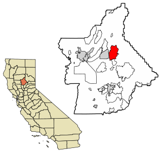
Butte County is a county located in the northern part of the U.S. state of California. In the 2020 census, its population was 211,632. The county seat is Oroville.

<span class="mw-page-title-main">Plumas County, California</span> County in California, United States

Plumas County is a county in the Sierra Nevada of the U.S. state of California. As of the 2020 census, the population was 19,790. The county seat is Quincy, and the only incorporated city is Portola. The largest community in the county is East Quincy. The county was named for the Spanish Río de las Plumas, which flows through it. The county itself is also the namesake of a native moth species, Hadena plumasata.

<span class="mw-page-title-main">Concow, California</span> Unincorporated community in California, United States

Concow is an unincorporated community and census-designated place (CDP) in the Sierra Nevada foothills covering eastern Butte County, California. Due to a decline in employment and repeated wildfires, over the past hundred years the population declined from several thousand to several dozen. On November 8, 2018, a wildfire, the Camp Fire, destroyed most of Concow, as well as the adjacent municipality of Paradise.

<span class="mw-page-title-main">Susanville, California</span> City in California, United States

Susanville is a town in and is the county seat of Lassen County, California, United States. Susanville is located on the Susan River in the southern part of the county, at an elevation of 4,186 feet (1,276 m). Its population is 16,728 as of the 2020 census, down from 17,947 from the 2010 census. The Susanville urban area contains 8,995 people and 4,233 households.

<span class="mw-page-title-main">Shasta Cascade</span> Mountainous region of California

The Shasta Cascade region of California is located in the northeastern and north-central sections of the state bordering Oregon and Nevada, including far northern parts of the Central Valley and the Sierra Nevada mountain range.

<span class="mw-page-title-main">Bidwell Park</span> Municipal park in Chico, California

Bidwell Park is a municipal park located in Chico, California. The park was established July 10, 1905, through the donation by Annie Bidwell, widow of Chico's founder, John Bidwell, of approximately 2,500 acres of land to the City of Chico. Since that time, the city has purchased additional land, such as Cedar Grove in 1922, and 1,200 acres (490 ha) of land south of Big Chico Creek in upper Bidwell Park in 1995. As of 2009, the total park size is 3,670 acres (1,490 ha), nearly 11 miles (18 km) in length, making it the third largest municipal park in California and is one of the largest city parks in the United States.

<span class="mw-page-title-main">John Bidwell</span> American politician

John Bidwell, known in Spanish as Don Juan Bidwell, was a Californian pioneer, politician, and soldier. Bidwell is known as the founder of the city of Chico, California.

<span class="mw-page-title-main">California Trail</span> Historic migration route in the western United States

The California Trail was an emigrant trail of about 1,600 mi (2,600 km) across the western half of the North American continent from Missouri River towns to what is now the state of California. After it was established, the first half of the California Trail followed the same corridor of networked river valley trails as the Oregon Trail and the Mormon Trail, namely the valleys of the Platte, North Platte, and Sweetwater rivers to Wyoming. The trail has several splits and cutoffs for alternative routes around major landforms and to different destinations, with a combined length of over 5,000 mi (8,000 km).

<span class="mw-page-title-main">California State Route 32</span> Highway in California

State Route 32 is an east–west state highway in the U.S. State of California which is routed from Interstate 5 in Orland, across the Sacramento Valley and through Chico, through the northern Sierra Nevada, and ending at SR 36 and SR 89 in eastern Tehama County.

<span class="mw-page-title-main">California State Route 36</span> Highway in California

State Route 36 is an east–west state highway in the U.S. state of California that is routed from U.S. Route 101 in Humboldt County to U.S. Route 395 just east of Susanville in Lassen County. The highway passes through Red Bluff, the county seat of Tehama County, on the northern edge of the Sacramento Valley. The portion of SR 36 travelling past Lassen Volcanic National Park and Lake Almanor is part of the Volcanic Legacy Scenic Byway, a National Scenic Byway. Also, Route 36 between Alton and Susanville is a designated Blue Star Memorial Highway.
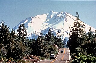
<span class="mw-page-title-main">Area code 530</span> Area code in northern California

Area code 530 is a telephone area code in the North American Numbering Plan (NANP) in northeastern and Northern California. It was created in 1997 in an area code split of 916.

<span class="mw-page-title-main">Forest Ranch, California</span> Unincorporated community in California, United States

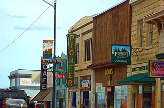
Forest Ranch is an unincorporated community and census-designated place in Butte County, California. It includes Forest Ranch Charter School (K-8), its own post office, and a CDF and Volunteer fire stations. The community's ZIP code is 95942, and is shared with the community of Butte Meadows. The area code is 530. Forest Ranch's population was 1,184 at the 2010 census.

<span class="mw-page-title-main">Joseph R. Walker</span> American explorer

Joseph R. Walker was a mountain man and experienced scout. He established the segment of the California Trail, the primary route for the emigrants to the gold fields during the California gold rush, from Fort Hall, Idaho to the Truckee River. The Walker River and Walker Lake in Nevada were named for him by John C. Frémont.

The Central Overland Route was a transportation route from Salt Lake City, Utah south of the Great Salt Lake through the mountains of central Nevada to Carson City, Nevada. For a decade after 1859, until the first Transcontinental Railroad was completed in 1869, it served a vital role in the transport of emigrants, mail, freight, and passengers between California, Nevada, and Utah.

<span class="mw-page-title-main">History of Chico, California</span> Aspect of history

The history of Chico, California, begins with the original inhabitants, the Mechoopda Maidu.

The Butte County High Point is on Robert Jenkins mountain ridge located on the boundary between Butte and Plumas counties in the Sierra Nevada of California.

<span class="mw-page-title-main">Nome Cult Trail</span>

The Nome Cult Trail is a northern Californian historic trail located in present-day Mendocino National Forest which goes along Round Valley Road and through Rocky Ridge and the Sacramento Valley. It is also known as the Konkow Trail of Tears. On August 28, 1863, all Konkow Maidu were to be at the Bidwell Ranch in Chico to be taken to the Round Valley Reservation at Covelo in Mendocino County. Any Native Americans remaining in the area were to be shot. 435 Maidu were rounded up and marched under guard west out of the Sacramento Valley and through to the Coastal Range. 461 Native Americans started the trek, 277 finished. They reached Round Valley on September 18, 1863.

Jonesville is an unincorporated community in Butte County, California. It is situated on Jones Creek, 5 miles (8.0 km) east-northeast of Butte Meadows, at an elevation of 5049 feet.

Lomo is an unincorporated community in Butte County, California. It lies 4.5 miles (7.2 km) of Butte Meadows, at an elevation of 3779 feet.

<span class="mw-page-title-main">Nobles Emigrant Trail</span> United States historic place

The Nobles Emigrant Trail, also known as the Fort Kearney, South Pass and Honey Lake Wagon Road, is a trail in California that was used by emigrant parties from the east as a shortened route to northern California. It was pioneered in 1851 by William Nobles, who discovered an easy shortcut between the Applegate Trail in Nevada and the Lassen Trail in California. The trail was extensively used until the 1870s, when it was superseded by railroads.

References

  1. 1 2 Leicester, Marti; Nopel, David (2012). The Humboldt Wagon Road. Images of America. Charleston, South Carolina: Arcadia Publishing. p. 11. ISBN   978-0-7385-7643-5.
  2. Chang, Anita L. (1992). The Historical Geography of the Humboldt Wagon Road. Chico, California: Association for Northern California Records and Research. pp. 58–59.
  3. 1 2 Mark, Andy (2020). Stories of the Humboldt Wagon Road. Charleston, South Carolina: The History Press. pp. 14–15. ISBN   978-1-4396-6978-5.
  4. Chang (1992), p. 19.
  5. Urseny, Laura (May 25, 2008). "Saving ruts: Citizen – Piece of area's history needs protection". Chico Enterprise-Record. Retrieved November 24, 2023.
  6. Mark (2020), p. 89.
  7. Mark (2020), p. 28.
  8. Leek, Nancy (2018). "Chapter 1: John Bidwell and the Humboldt Wagon Road". In White, Gregory F. (ed.). Ten Miles of Roadside Archaeology Along the Old Humboldt Wagon Road. Association for Northern California Historical Research. p. 12. ISBN   978-1-931994-29-3.
  9. Leicester & Nopel (2012), p. 8.
  10. Leek (2018), p. 4.
  11. Leek (2018), pp. 6–9.
  12. Chang (1992), p. 15.
  13. Mark (2020), pp. 26–27.
  14. Leicester & Nopel (2012), p. 28.
  15. Leek (2018), p. 9.
  16. Mark (2020), pp. 85–86.
  17. Mark (2020), pp. 27–29.
  18. Leicester & Nopel (2012), p. 19.
  19. McGie, Joseph F. (1982). History of Butte County, Volume I. Oroville, California: Butte County Board of Education. p. 164.
  20. Chang (1992), pp. 20–27.
  21. Chang (1992), p. 31.
  22. Mark (2020), p. 64.
  23. Mark (2020), pp. 94–96.
  24. "Busy Scenes". Weekly Butte Record. November 24, 1883. p. 1. Retrieved December 27, 2023.
  25. 1 2 Shuffleton, J. H. (October 15, 1897). "The Humboldt Road". Chico Weekly Enterprise. p. 2. Retrieved December 18, 2023.
  26. 1 2 Leek (2018), pp. 21–22.
  27. "Humboldt Road Fund". Chico Daily Record. January 5, 1899. p. 4.
  28. Chang (1992), p. 35.
  29. McGie (1982), p. 165.
  30. Edmonson, Barbara T. (1992). "John Bidwell's Fifty Years on Rancho del Arroyo Chico". In McDonald, Lois Halliday (ed.). Ripples Along Chico Creek. Chico, California: Butte County Branch, National League of American Pen Women. p. 61. ISBN   0-9631582-2-8.
  31. 1 2 Chang (1992), p. 43.
  32. Mark (2020), p. 17.
  33. Quadrio, Marilyn Morris (2014). Big Meadows and Lake Almanor. Charleston, South Carolina: Arcadia Publishing. p. 7. ISBN   978-1-4671-3229-9.
  34. Leicester & Nopel (2012), p. 7.
  35. Chang (1992), pp. 39–44.
  36. Mark (2020), p. 148.
  37. Mark (2020), pp. 145–146.
  38. Mark (2020), p. 72.
  39. City, Steve; Schoonover, Steve (June 27, 2007). "Grand jury wants new look at protecting Humboldt Wagon Road". Chico Enterprise-Record. Retrieved November 18, 2023.
  40. Hutchison, Jake (April 21, 2022). "Chico closes its portion of Humboldt Road". Chico Enterprise-Record. Retrieved November 18, 2023.