Gawler Ranges National Park is a 1,633 km2 (631 sq mi) protected area lying 350 km (217 mi) north-west of Adelaide in the northern Eyre Peninsula of South Australia. It is known for its spectacular rock formations.
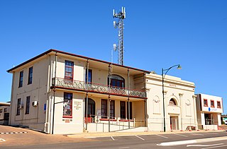
The District Council of Streaky Bay is a local government area in South Australia located on the Eyre Peninsula. Streaky Bay is the main population centre of about 1,200 people serving an agricultural district based on farming wheat and other cereal crops, sheep, supplemented by fishing and tourism industries. The district covers an area of 6,251.1 square kilometres with a population of 2,074 people in 2016, according to the Australian Bureau of Statistics. Mayor of Streaky Bay is Travis Barber.

Streaky Bay is a coastal town on the western side of the Eyre Peninsula, in South Australia just off the Flinders Highway, 303 km (188 mi) north-west of Port Lincoln and 727 km (452 mi) by road from Adelaide. At the 2016 census, Streaky Bay recorded a population of 1,378.
The Mid West Football League was an Australian rules football competition based in the Eyre Peninsula region of South Australia, Australia. It was wound up prior to the 2021 season after Wudinna and Central Eyre merged and transferred to the Eastern Eyre Football League.

Wudinna District Council is a rural local government area on central Eyre Peninsula, South Australia. Its seat is Wudinna, on the Eyre Highway, 580 kilometres (360 mi) west of Adelaide. The district's economy is largely driven by agriculture, mainly cereal crops, with beef and sheep commonly farmed as well.
Perlubie is a locality in the Australian state of South Australia located on the west coast of Eyre Peninsula about 472 kilometres (293 mi) north-west of the state capital of Adelaide and about 24 kilometres (15 mi) north-east of the municipal seat of Streaky Bay.

Warramboo (wɔrˑræmˑbʉː) is a locality in the Australian state of South Australia located on the Eyre Peninsula about 334 kilometres (208 mi) north-west of the state capital of Adelaide and about 26 kilometres (16 mi) south-east of the municipal seat of Wudinna. It is 189 kilometres (117 mi) north of Port Lincoln on the Tod Highway and is the north-western terminus of the wheat haulage lines radiating from Port Lincoln on the Eyre Peninsula Railway. The railway line was built from 1907–1915 to develop the cereal industry. The grain silos are a distinctive local landmark of the town.

The County of Robinson is one of the 49 counties of South Australia. It was proclaimed in 1883 by Governor William Robinson who named it after himself. It lies on the north west coast of Eyre Peninsula stretching from Streaky Bay inland to include the Gawler Ranges Conservation Park at the southern cusp of the Gawler Ranges.
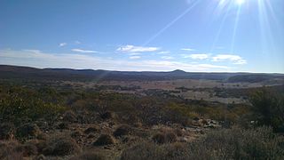
Gawler Ranges is a locality in the Australian state of South Australia located on Eyre Peninsula about 380 kilometres north-west of the Adelaide city centre and about 48 kilometres north of the town centre of Wudinna and which is associated with the protected area known as the Gawler Ranges National Park.
Cocata is a rural locality in the Eyre and Western region of South Australia.
The County of Bosanquet is a cadastral unit in the Australian state of South Australia that covers land both in the north of the Eyre Peninsula and to the peninsula's north. It was proclaimed on 23 October 1913 and was named after Sir Day Hort Bosanquet, the Governor of South Australia from 1909 to 1914.

County of Le Hunte is a cadastral unit located in the Australian state of South Australia that covers land located in the centre of Eyre Peninsula. It was proclaimed in 1908 and named after George Le Hunte who was the Governor of South Australia from July 1903 to February 1909.

The County of Way is one of the 49 counties of South Australia on the state's west coast. It was proclaimed circa 1889 by Governor William Robinson and named for Samuel Way, the Chief Justice of the state's Supreme Court at the time.
The Hundred of Karcultaby is a cadastral unit of hundred located on the northern Eyre Peninsula of South Australia spanning the townships of Poochera, Karcultaby and surrounds. One of the 24 hundreds of the County of Robinson, it was proclaimed in 1913 by Governor Day Bosanquet and named for Karcultaby Homestead, in the extreme southeast of the hundred.
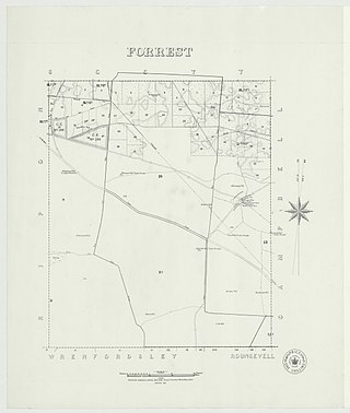
The Hundred of Forrest is a cadastral hundred of the County of Robinson in South Australia.
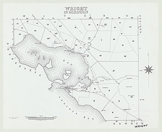
The Hundred of Wright is a cadastral hundred of County of Robinson in South Australia. It spans the west coast of the state at Venus Bay, 655 kilometres (407 mi) west of Adelaide.

The Hundred of Murray is a cadastral hundred in the County of Robinson, South Australia. It occupies land midway between the towns of Streaky Bay and Poochera.
The Hundred of Grace is a cadastral unit of hundred located on the northern Adelaide Plains of South Australia spanning the township of Mallala and the Grace Plains. The hundred was proclaimed in 1856 in the County of Gawler and named by Governor Richard Graves MacDonnell after Grace Montgomery Farrell, wife of James Farrell, Dean of Adelaide. The hundred spans a significant portion of the lower Light River, which flows from north east to south west through the area.
The West Coast Sentinel is a weekly newspaper published Thursdays in Ceduna, South Australia. It was founded in mid-1912, and has been published continuously since then. It was later sold to Rural Press, previously owned by Fairfax Media, but now an Australian media company trading as Australian Community Media.
