
The 2005 Pacific hurricane season was a near-average season which produced fifteen named storms, only seven hurricanes formed and two major hurricanes. It was also the second consecutive season in which no tropical cyclone of at least tropical storm intensity made landfall. The season officially began on May 15 in the East Pacific Ocean, and on June 1 in the Central Pacific; they ended on November 30. These dates conventionally delimit the period of each year when most tropical cyclones form in the Pacific basin. However, the formation of tropical cyclones is possible at any time of the year.

The 1999 Pacific hurricane season was one of the least active Pacific hurricane seasons on record. The season officially began on May 15 in the Eastern Pacific, and on June 1 in the Central Pacific; in both basins, it ended on November 30. These dates conventionally delimit the period during which most tropical cyclones form in the northeastern Pacific Ocean. The first tropical cyclone of the season, Hurricane Adrian, developed on June 18, while the final storm of the season, Tropical Storm Irwin, dissipated on October 11. No storms developed in the Central Pacific during the season. However, two storms from the Eastern Pacific, Dora and Eugene, entered the basin, with the former entering as a hurricane.

The 1993 Pacific hurricane season included more than double the average number of major hurricanes – Category 3 or stronger cyclones on the Saffir–Simpson scale. This activity was the result of an El Niño event, which is the main factor contributing to above-average activity across the Pacific basin. The season featured 15 named storms, 11 hurricanes, and 9 major hurricanes. While the number of named storms was near the long-term average, the number of hurricanes was above the average of 8, and the number of major hurricanes far exceeded the long-term average of 4. Seasonal activity began on May 17 and ended on November 8, within the confines of a traditional hurricane season which begins on May 15 in the East Pacific and June 1 in the Central Pacific. The season ends on November 30 in both basins. These dates conventionally delimit the period during each year when most tropical cyclones form.

The 1988 Pacific hurricane season was the least active Pacific hurricane season since 1981. It officially began May 15, in the eastern Pacific, and June 1, in the central Pacific and lasted until November 30. These dates conventionally delimit the period of each year when most tropical cyclones form in the northeastern Pacific Ocean. The first named storm, Tropical Storm Aletta, formed on June 16, and the last-named storm, Tropical Storm Miriam, was previously named Hurricane Joan in the Atlantic Ocean before crossing Central America and re-emerging in the eastern Pacific; Miriam continued westward and dissipated on November 2.

The 1983 Pacific hurricane season was the longest season ever recorded at that time. It was a very active Pacific hurricane season. The season started on May 15, 1983 in the eastern Pacific, and on June 1, 1983 in the central Pacific, and lasted until November 30, 1983. These dates conventionally delimit the period of each year when most tropical cyclones form in the northeastern Pacific Ocean. During the 1983 season, there were 21 named storms, which was slightly less than the previous season. Furthermore, twelve of those storms became hurricanes. And eight of the storms reached major hurricane status, or Category 3 or higher on the Saffir–Simpson hurricane wind scale (SSHWS). The decaying 1982–83 El Niño event likely contributed to this level of activity. That same El Niño influenced a very quiet Atlantic hurricane season.

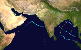
The 1992 North Indian Ocean cyclone season was unofficially the most active year on record for the basin, with 10 tropical storms developing, according to the Joint Typhoon Warning Center (JTWC). There are two main seas in the North Indian Ocean – the Bay of Bengal to the east of the Indian subcontinent – and the Arabian Sea to the west of India. The official Regional Specialized Meteorological Centre in this basin is the India Meteorological Department (IMD), while the JTWC releases unofficial advisories. An average of four to six storms form in the North Indian Ocean every season with peaks in May and November. Cyclones occurring between the meridians 45°E and 100°E are included in the season by the IMD.

Tropical Storm Bret was the deadliest natural disaster in Venezuela since the 1967 Caracas earthquake. The third tropical cyclone of 1993 Atlantic hurricane season, Bret formed on August 4 from a westward-moving, African tropical wave. Bret would later peak as a 60 mph (97 km/h) tropical storm as it neared Trinidad. It took an extremely southerly course through the Caribbean, passing over the coasts of Venezuela and Colombia. High terrain in the northern parts of those countries severely disrupted the circulation of the storm, and Bret had weakened to a tropical depression before emerging over the extreme southwestern Caribbean Sea. There, it restrengthened to a tropical storm and made landfall in Nicaragua on August 10, dissipating soon after. Bret's remnants reached the Pacific Ocean, where they ultimately became Hurricane Greg.

Hurricane Calvin was one of three Pacific hurricanes on record to make landfall along the Mexican coast during the month of July. The fourth tropical cyclone, third named storm, and second hurricane of the 1993 Pacific hurricane season, Calvin developed from an area of convection to the south of Mexico on July 4. The following day, the system intensified into a tropical storm, which was named Calvin. Continued strengthening ensued as Calvin curved from its initial westward track northward, and was upgraded to a hurricane on July 6 Calvin eventually turned northwest, and became a Category 2 hurricane on the Saffir–Simpson hurricane wind scale (SSHWS). By July 7, Hurricane Calvin made landfall near Manzanillo at peak strength. Calvin rapidly weakened after landfall, and was a tropical storm when it reemerged into the Pacific Ocean on early on July 8. Despite this, the hurricane did not reintensify, and continued to weaken as it headed rapidly northwestward. As Calvin made a second Mexican landfall near the southern tip of Baja California peninsula late on July 8, it weakened to a tropical depression. Early on July 9, the depression dissipated shortly after entering the Pacific Ocean for a third time.

The 2008 Pacific hurricane season was a near-average Pacific hurricane season which featured seventeen named storms, though most were rather weak and short-lived. Only seven hurricanes formed and two major hurricanes. This season was also the first since 1996 to have no cyclones cross into the central Pacific. The season officially began on May 15 in the eastern Pacific and on June 1 in the central Pacific. It ended in both regions on November 30. These dates, adopted by convention, historically describe the period in each year when most tropical cyclone formation occurs in these regions of the Pacific. This season, the first system, Tropical Storm Alma, formed on May 29, and the last, Tropical Storm Polo, dissipated on November 5.

The 2012 Pacific hurricane season was a moderately active Pacific hurricane season that saw an unusually high number of tropical cyclones pass west of the Baja California Peninsula. The season officially began on May 15 in the eastern Pacific Ocean, and on June 1 in the central Pacific (from 140°W to the International Date Line, north of the equator; they both ended on November 30. These dates conventionally delimit the period of each year when most tropical cyclones form in these regions of the Pacific Ocean. However, the formation of tropical cyclones is possible at any time of the year. This season's first system, Tropical Storm Aletta, formed on May 14, and the last, Tropical Storm Rosa, dissipated on November 3.

Hurricane Greg was the only eastern Pacific tropical cyclone in 1999 to make a direct landfall. Part of the annual hurricane season, Greg originated from a tropical wave that departed Africa in mid-August. The wave entered the eastern Pacific by September 1, steadily organizing over subsequent days to become a tropical depression on September 5. Amid a favorable environment, the cyclone intensified into Tropical Storm Greg a few hours after formation and further organized into a Category 1 hurricane on September 6. Greg paralleled the southwestern coastline of Mexico, where it destroyed over 250 homes, cut-off roads, killed 10 people, and left at least 4,000 more injured. The storm weakened to tropical storm intensity as it moved ashore Baja California Sur, although rain was generally beneficial there. Succumbing to cooler waters and high wind shear, Greg ultimately dissipated over the Pacific on September 9. Its remnants led to thunderstorms across northern California, with only minor impacts.
The 1995 North Indian Ocean cyclone season was below-average and was primarily confined to the autumn months, with the exception of three short-lived deep depressions in May. There were eight depressions in the basin, which is Indian Ocean north of the equator. The basin is subdivided between the Bay of Bengal and the Arabian Sea on the east and west coasts of India, respectively. Storms were tracked by the India Meteorological Department (IMD), which is the basin's Regional Specialized Meteorological Center, as well as the American-based Joint Typhoon Warning Center (JTWC) on an unofficial basis.

The 2017 Pacific hurricane season was an above average Pacific hurricane season in terms of named storms, though less active than the previous three, featuring eighteen named storms, nine hurricanes, and four major hurricanes. Despite the considerable amount of activity, most of the storms were weak and short-lived. The season officially started on May 15 in the eastern Pacific Ocean, and on June 1 in the central Pacific; they both ended on November 30. These dates conventionally delimit the period of each year when most tropical cyclones form in the respective regions. However, the formation of tropical cyclones is possible at any time of the year, as illustrated in 2017 by the formation of the season's first named storm, Tropical Storm Adrian, on May 9. At the time, this was the earliest formation of a tropical storm on record in the eastern Pacific basin proper. The season saw near-average activity in terms of accumulated cyclone energy (ACE), in stark contrast to the extremely active seasons in 2014, 2015, and 2016; and for the first time since 2012, no tropical cyclones formed in the Central Pacific basin. However, for the third year in a row, the season featured above-average activity in July, with the ACE value being the fifth highest for the month. Damage across the basin reached $375.28 million (2017 USD), while 45 people were killed by the various storms.

The 2010 Pacific hurricane season was one of the least active seasons on record, featuring the fewest named storms since 1977. The season officially started on May 15 in the eastern Pacific—east of 140°W—and on June 1 in the central Pacific—between the International Date Line and 140°W—and lasted until November 30. These dates typically cover the period of each year when most tropical cyclones form in the eastern Pacific basin. The season's first storm, Tropical Storm Agatha, developed on May 29; the season's final storm, Tropical Storm Omeka, degenerated on December 21.

Extremely Severe Cyclonic Storm Forrest, also referred to as Tropical Storm Forrest while in the western Pacific basin before its Thai crossover, was a powerful tropical cyclone that prompted the evacuation of 600,000 people in Bangladesh in late November 1992. Originating from an area of disturbed weather near the Caroline Islands on November 9, Forrest was classified as a tropical depression three days later over the South China Sea. Tracking generally west, the system steadily organized into a tropical storm, passing Vietnam to the south, before striking Thailand along the Malay Peninsula on November 15. Once over the Bay of Bengal, Forrest turned northward on November 17 and significantly intensified. It reached its peak intensity on November 20 as a Category 4-equivalent cyclone on the Saffir–Simpson hurricane scale with winds of 230 km/h (140 mph). Hostile environmental conditions soon affected the cyclone as it turned abruptly east-northeastward. Forrest made landfall in northwestern Myanmar as a weakening system on November 21 before dissipating early the next day.

The 2019 Pacific hurricane season was a near average season which produced nineteen named storms, though most were rather weak and short-lived. Only seven hurricanes formed, the fewest since 2010. The season officially began on May 15 in the East Pacific Ocean, and on June 1 in the Central Pacific; they both ended on November 30. These dates conventionally delimit the period of each year when most tropical cyclones form in the Pacific basin. This season was one of the latest-starting Pacific hurricane seasons on record, with the first tropical cyclone, Hurricane Alvin, forming on June 25. The final system, Tropical Depression Twenty-One-E, dissipated on November 18.

The 2020 Pacific hurricane season was the least active Pacific hurricane season since 2011. Altogether, 21 tropical cyclones developed. The season was near average in terms of tropical storms, featuring a total of 17, but had a well below average number of hurricanes and major hurricanes, with only 4 hurricanes and 3 major hurricanes forming including one unnamed tropical storm which was operationally classified as a tropical depression, the first such occurrence since 2001. Furthermore, it was the first season since 2017 in which no tropical cyclones formed in the Central Pacific basin, marking the start of a series of three consecutive seasons with low activity, spanning from 2020 to 2022. The season officially began on May 15 in the East Pacific Ocean, and on June 1 in the Central Pacific (from 140°W to the International Date Line, north of the equator; they both ended on November 30. These dates conventionally delimit the period of each year when most tropical cyclones form in the respective regions. However, the formation of tropical cyclones is possible at any time of the year, as illustrated in 2020 by the formation of the season's first system, Tropical Depression One-E, on April 25. This the earliest formation of a tropical cyclone on record in the eastern Pacific basin proper.

The 2021 Pacific hurricane season was a moderately active Pacific hurricane season, with above-average tropical activity in terms of named storms; but featured below-average activity in terms of major hurricanes and a near-normal accumulated cyclone energy (ACE). It is the first season to have at least five systems make landfall in Mexico, the most since 2018. The season officially began on May 15 in the Eastern Pacific, and on June 1 in the Central Pacific; both ending on November 30. These dates historically describe the period each year when most tropical cyclones form in the Pacific basin and are adopted by convention. However, the formation of tropical cyclones is possible at any time of the year, as illustrated by the formation of Tropical Storm Andres on May 9, which became the earliest forming tropical storm in the northeastern Pacific proper on record. Despite this, it was the second consecutive season in which no tropical cyclones formed in the Central Pacific basin.

The 2022 Pacific hurricane season was a fairly active Pacific hurricane season, with nineteen named storms, ten hurricanes, and four major hurricanes forming. Also, it was the third consecutive season in which no tropical cyclones formed in the Central Pacific Ocean. The season officially began on May 15 in the Eastern Pacific, and on June 1 in the Central Pacific; both ended on November 30. These dates historically describe the period each year when most tropical cyclogenesis occurs in these regions of the Pacific and are adopted by convention.

Hurricane Dolores was a powerful and moderately damaging tropical cyclone whose remnants brought record-breaking heavy rains and strong winds to California. The seventh named storm, fourth hurricane, and third major hurricane of the record-breaking 2015 Pacific hurricane season, Dolores formed from a tropical wave on July 11. The system gradually strengthened, attaining hurricane status on July 13. Dolores rapidly intensified as it neared the Baja California peninsula, finally peaking as a Category 4 hurricane on the Saffir–Simpson scale with winds of 130 mph (215 km/h) on July 15. An eyewall replacement cycle began and cooler sea-surface temperatures rapidly weakened the hurricane, and Dolores weakened to a tropical storm two days later. On July 18, Dolores degenerated into a remnant low west of the Baja California peninsula.


