
Honolulu is the capital and largest city of the U.S. state of Hawaiʻi. It is an unincorporated part of and the county seat of the City and County of Honolulu along the southeast coast of the island of Oʻahu. The city is the main gateway to Hawaiʻi and a major portal into the United States. The city is also a major hub for international business, military defense, as well as famously being host to a diverse variety of east-west and Pacific culture, cuisine, and traditions.
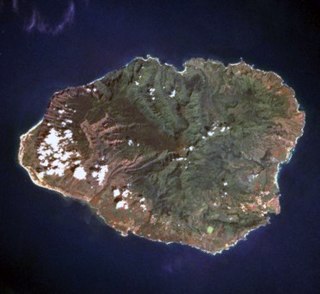
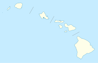
Kauaʻi, anglicized as Kauai, is geologically the oldest of the main Hawaiian Islands. With an area of 562.3 square miles (1,456.4 km2), it is the fourth-largest of these islands and the 21st largest island in the United States. Known also as the "Garden Isle", Kauaʻi lies 105 miles (169 km) across the Kauaʻi Channel, northwest of Oʻahu. This island is the site of Waimea Canyon State Park.

Kauaʻi County is a county in the U.S. state of Hawaiʻi. It consists of the islands of Kauaʻi, Niʻihau, Lehua, and Kaʻula. As of the 2010 Census the population was 67,091. The county seat is Līhuʻe.

Native Hawaiians are the Aboriginal Polynesian people of the Hawaiian Islands or their descendants. Native Hawaiians trace their ancestry back to the original Polynesian settlers of Hawaiʻi. In total, 527,000 Americans consider themselves Native Hawaiian.
The following is an alphabetical list of articles related to the U.S. state of Hawaii:

The reef triggerfish, also known as the rectangular triggerfish or by its Hawaiian name humuhumunukunukuāpuaʻa, also spelled humuhumunukunukuapua'a or just humuhumu for short, is one of several species of triggerfish. It is found at reefs in the Indo-Pacific and is the state fish of Hawaii.

The Hawaiian sovereignty movement is a grassroots political and cultural campaign to gain sovereignty, self-determination and self-governance for Hawaiians of whole or part Native Hawaiian ancestry with an autonomous or independent nation or kingdom. Some groups also advocate some form of redress from the United States for the 1893 overthrow of Queen Liliʻuokalani, and for what is described as a prolonged military occupation beginning with the 1898 annexation. The movement generally views both the overthrow and annexation as illegal. Palmyra Island and the Stewart Islands were annexed by the Kingdom in the 1860s and are regarded by the movement as being under illegal occupation along with the Hawaiian Islands. The Apology Resolution passed by the United States Congress in 1993 acknowledged that the overthrow of the Kingdom of Hawaii in 1893 was an illegal act.

Hāʻena State Park is a state park located on the north shore of the Hawaiian island of Kauaʻi. It is often referred to as the "end of the road" and marks the end point of the Kuhio Highway. The park provides access to beaches, trails, and several ancient Hawaiian sites, including sea caves estimated to be more than 4,000 years old. Archaeological sites associated with the hula, including a heiau (shrine) dedicated to Laka, are located above the park's beaches.

Puʻuwai is an unincorporated community in Kauai County, Hawaii, United States, and the only settlement on the island of Niʻihau. It is at the western coast of the small island, and Native Hawaiians who live in this village speak the Hawaiian language. The community lives as they did hundreds of years ago, and the modern amenities of life are extremely limited. Access to the town is limited to Niʻihau residents. Only official visitors and invited guests are permitted. Puʻuwai has a one-room schoolhouse. Niʻihau is located about 29 km (18 mi) west of Kauaʻi.

This is a list of properties and historic districts in Hawaii listed on the National Register of Historic Places. More than 340 listings appear on all but one of Hawaii's main islands and the Northwestern Islands, and in all of its five counties. Included are houses, schools, archeological sites, ships, shipwrecks and various other types of listings. These properties and districts are listed by island, beginning at the northwestern end of the chain.
Pacific Islands Americans, also known as Oceanian Americans, Pacific Islander Americans or Native Hawaiian and/or other Pacific Islander Americans, are Americans who have ethnic ancestry among the indigenous peoples of Oceania. For its purposes, the U.S. Census also counts Indigenous Australians as part of this group.

Route 560, or Kaua'i Belt Road-North Shore section, is a ten-mile (16 km) scenic road on the northern shore of the island of Kauaʻi in Hawaii. The entire belt road is signed as the Kuhio Highway and Hawaii Route 56 was once signed on this route before it was downgraded to become Hawaii Route 560 in the late 1960s. The Kuhio Highway is named after Jonah Kūhiō Kalaniana'ole, the second non-voting Congressional Delegate from territorial Hawaii.

The Tahitians, or Maohis, are a nation and Polynesian ethnic group native to Tahiti and thirteen other Society Islands in French Polynesia, as well as the modern population of these lands of multiracial, primarily Polynesian-French, ancestry. The Tahitians are one of the largest indigenous Polynesian ethnic groups, behind the Māori, Samoans and Hawaiians.

William Herbert Shipman (1854–1943) was a wealthy businessman on the island of Hawaii. One estate of his family was used to preserve an endangered species of Hawaiian goose. A historic house associated with his family for over a hundred years is called the W. H. Shipman House in Hilo, Hawaii. Another of his historic estates called the Ainahou Ranch, built in 1941 as a refuge from World War II, is preserved within Hawaii Volcanoes National Park.

The KūʻēPetitions of 1897 were a protest against the annexation of Hawaii by the United States. Also referred to as the "monster petition".
The Haena Archeological Complex, on Kauai near Hanalei, Hawaii, is an archeological site complex that is listed on the U.S. National Register of Historic Places.
Hāʻena may refer to the following places in the U.S. state of Hawaii:
Hāʻena is an unincorporated community and census-designated place on the island of Kauai in Kauai County, Hawaii, United States. Its population was 431 as of the 2010 census. The community is located on the north side of the island along Hawaii Route 560.

In April 2018, a series of thunderstorms produced record-breaking rainfall on the Hawaiian Islands of Kauaʻi and Oahu. An upper-level low moved across the area on April 13, generating a mesoscale convective system that moved over eastern Oahu, producing localized heavy rainfall that reached 5.55 in (141 mm). The heaviest rainfall occurred on northern Kauaʻi. There, a rain gauge owned by the Waipā Foundation, just west of Hanalei, recorded 49.69 in (1,262 mm) of rainfall in the 24 hours between 12:45 p.m. on April 14 and 15. This was the greatest 24-hour rainfall total on record in the United States, surpassing the previous record of 43 in (1,100 mm) in Alvin, Texas on July 25–26, 1979, set during Tropical Storm Claudette. Through the entire event, the same gauge recorded a total of 54.37 in (1,381 mm) of rain.


