Ica Region

Last updated
Ica Region
Region
Nazca-lineas-perro-c01.jpg
Nazca Lines: "Dog"
Bandera Region Ica.png
Flag
Escudo Region Ica.png
Seal
Peru - Ica Department (locator map).svg
Location of the Ica Region in Peru
Country Peru
Subdivisions 5 provinces and 43 districts
Capital Ica
Government
  Governor Fernando Cillóniz
(2015-2018)
Area
  Total 21,327.83 km2 (8,234.72 sq mi)
Elevation(Capital) 406 m (1,332 ft)
Highest elevation 3,796 m (12,454 ft)
Lowest elevation 0 m (0 ft)
Population (2004 estimate)
  Total 709,556
  Density 33/km2 (86/sq mi)
Dialing code 056
ISO 3166 code PE-ICA
Principal resources Iron, cotton, grapevine, kidney beans.
Poverty rate 41.7%
Percentage of Peru's GDP 2.36%
Website www.regionica.gob.pe

Ica (Spanish pronunciation:  [ˈika] ; Quechua : Ika) is a region (formerly known as a department) in Peru. It borders the Pacific Ocean on the west; the Lima Region on the north; the Huancavelica and Ayacucho regions on the east; and the Arequipa Region on the south. Its capital is the city of Ica.

Peru republic in South America

Peru, officially the Republic of Peru, is a country in western South America. It is bordered in the north by Ecuador and Colombia, in the east by Brazil, in the southeast by Bolivia, in the south by Chile, and in the west by the Pacific Ocean. Peru is a megadiverse country with habitats ranging from the arid plains of the Pacific coastal region in the west to the peaks of the Andes mountains vertically extending from the north to the southeast of the country to the tropical Amazon Basin rainforest in the east with the Amazon river.

Pacific Ocean Ocean between Asia and Australia in the west, the Americas in the east and Antarctica or the Southern Ocean in the south.

The Pacific Ocean is the largest and deepest of Earth's oceanic divisions. It extends from the Arctic Ocean in the north to the Southern Ocean in the south and is bounded by Asia and Australia in the west and the Americas in the east.

Contents

Geography

The Ica Region has a remarkable geography. It is the only region of the southern coast formed by plains, also called coast plains, since the Andean Cordillera rise up inland. Some geological folds have determined the formation of dunes moving toward the sea, which form much of the Paracas Peninsula. Some isolated formations located at the southern part created the Marcona complex, with the biggest deposits of iron in the Pacific coast.

A cordillera is an extensive chain of mountains or mountain ranges. The term is a borrowing from Spanish, in which it has the same meaning. The Spanish word originates from cordilla, a diminutive of "cuerda" or "rope". It is most commonly used in the field of physical geography.

Geology The study of the composition, structure, physical properties, and history of Earths components, and the processes by which they are shaped.

Geology is an earth science concerned with the solid Earth, the rocks of which it is composed, and the processes by which they change over time. Geology can also include the study of the solid features of any terrestrial planet or natural satellite such as Mars or the Moon. Modern geology significantly overlaps all other earth sciences, including hydrology and the atmospheric sciences, and so is treated as one major aspect of integrated earth system science and planetary science.

Paracas Peninsula peninsula in Peru

The Paracas Peninsula is a desert peninsula within the boundaries of the Paracas National Reserve, a marine reserve which extends south along the coast. The only marine reserve in Peru, it is a designated UNESCO World Heritage Site.

Ica's configuration is due to the geomorphology of its two big and unique fluvial watersheds: the Pasco and Ica rivers. Also, it has a waterway called the Rio Grande, although its waters do not reach the ocean. Some waters are diverted for irrigation and agriculture in the provinces of Pampa, Nazca and Ingenio; the Rio Grande's final riverbed is dry since sand and dried lands absorb its limited resources. There are extensive deserts in Ica, such as the Lancha Pampas . Pozo Santo and Villacuri pampas are extremely hot areas. Strong and persistent winds called paracas are present and stir up large sandstorms.

Geomorphology The scientific study of landforms and the processes that shape them

Geomorphology is the scientific study of the origin and evolution of topographic and bathymetric features created by physical, chemical or biological processes operating at or near the Earth's surface. Geomorphologists seek to understand why landscapes look the way they do, to understand landform history and dynamics and to predict changes through a combination of field observations, physical experiments and numerical modeling. Geomorphologists work within disciplines such as physical geography, geology, geodesy, engineering geology, archaeology, climatology and geotechnical engineering. This broad base of interests contributes to many research styles and interests within the field.

Ica River river in Peru

The Ica is a 220 kilometer long river in Peru which flows south from highlands in Huancavelica Region to the Pacific Ocean through Ica Region and passing the region's capital, the city of Ica.

Nazca Place in Ica, Peru

Nazca is a city and system of valleys on the southern coast of Peru. It is also the name of the largest existing town in the Nazca Province. The name is derived from the Nazca culture that flourished in the area between 100 BC and 800 AD. This culture was responsible for the Nazca Lines and the ceremonial city of Cahuachi; they also constructed an impressive system of underground aqueducts, named Puquios, that still function today.

History

Ica has a rich history. The first settlers are from 10,000 years ago, from which the Wari, Chincha, Nazca, Ica and Paracas cultures developed, the latter being the most important.

Chincha culture

The Chincha culture consisted of a Native American (Indian) people living near the Pacific Ocean in south west Peru. The Chincha Kingdom and their culture flourished in the Late Intermediate Period, also known as the regional states period of pre-Columbian Peru. They became part of the Inca Empire around 1480. They were prominent as sea-going traders and lived in a large and fertile oasis valley. La Centinela is an archaeological ruin associated with the Chincha. It is located near the present-day city of Chincha Alta.

Paracas culture archaeological culture

The Paracas culture was an Andean society existing between approximately 800 BCE and 100 BCE, with an extensive knowledge of irrigation and water management and that made significant contributions in the textile arts. It was located in what today is the Ica Region of Peru. Most information about the lives of the Paracas people comes from excavations at the large seaside Paracas site on the Paracas Peninsula, first investigated by the Peruvian archaeologist, Julio Tello, in the 1920s.

The Paracas culture developed from the seventh through the 2nd century BC. It is distinguished by its matchless textile skills, trephinations, and the art of mummifying their dead.

Textile Material produced by twining, weaving, felting, knotting, or otherwise processing natural or synthetic fibers

A textile is a flexible material consisting of a network of natural or artificial fibers. Yarn is produced by spinning raw fibres of wool, flax, cotton, hemp, or other materials to produce long strands. Textiles are formed by weaving, knitting, crocheting, knotting or tatting, felting, or braiding.

A mummy is a deceased human or an animal whose skin and organs have been preserved by either intentional or accidental exposure to chemicals, extreme cold, very low humidity, or lack of air, so that the recovered body does not decay further if kept in cool and dry conditions. Some authorities restrict the use of the term to bodies deliberately embalmed with chemicals, but the use of the word to cover accidentally desiccated bodies goes back to at least 1615 AD.

The Nazca culture, on the contrary, well known for its artistic pottery, in which colorful designs and representations excel over the form, the same as their famous lines and figures that have undergone implausible interpretations. This culture expanded from the 2nd century BC through the 7th century AD. They have left us their wonderful aqueducts that made good use of underground water, of rivers and rain, showing a great knowledge of hydraulic engineering.

Pottery craft of making objects from clay

Pottery is the process of forming vessels and other objects with clay and other ceramic materials, which are fired to give them a hard, durable form. Major types include earthenware, stoneware and porcelain. The place where such wares are made by a potter is also called a pottery. The definition of pottery used by the American Society for Testing and Materials (ASTM), is "all fired ceramic wares that contain clay when formed, except technical, structural, and refractory products." In archaeology, especially of ancient and prehistoric periods, "pottery" often means vessels only, and figures etc. of the same material are called "terracottas". Clay as a part of the materials used is required by some definitions of pottery, but this is dubious.

In the 15th century, during the Inca empire, Pachacuti incorporated the territories of Ica, Nazca and the Chincha valley.

Years later, in 1563, with the arrival of the Spanish, Jerónimo Luis de Cabrera founded the Villa de Valverde del Valle de Ica. Since then, the area became an important vineyard and cotton center.

During the independence war, General José de San Martín landed in Paracas and fixed his headquarters in Pisco, to start the fight for the independence of Peru.

Political division

Map of the Ica region showing its provinces Provinces of the Ica region in Peru.png
Map of the Ica region showing its provinces

The region is divided into five provinces (Spanish : provincias, singular: provincia), which are composed of 43 districts (distritos, singular: distrito).

Provinces

The provinces, with their capitals in parentheses, are:

Points of interest

Nazca Lines: figure of the Spider. Nazca-lineas-arana-c01.jpg
Nazca Lines: figure of the Spider.
Bay and harbor of San Nicolas in Marcona. San Nicolas Marcona.jpg
Bay and harbor of San Nicolás in Marcona.
Sea Lions on the Ballestas Islands. Islas Ballestas.jpg
Sea Lions on the Ballestas Islands.
Plaza de Armas in Ica, the oldest part of the capital of the department. Plaza armas ica noche.jpg
Plaza de Armas in Ica, the oldest part of the capital of the department.

City of Ica

Capital of the Ica Department. A very modern clean city that has popular Peruvian street markets, many old churches and landmarks, modern malls, hotels, coffee shops, theatres, and hotels as well.

Huacachina

Located on the west side of the city of Ica, capital of the Ica Department. One of the most popular places to visit in Ica is La Huacachina. The famous desert oasis is located 5 km from Ica. It is a small lake with medicinal water, lying in the middle of a spectacular sand desert.

Pisco

Pisco is the most important port in Ica and a litoral province. The most important attractions within this province are likely Paracas, Paracas Bay and the Paracas National Reserve. Pisco was home of an ancient pre-Hispanic culture, Paracas, who are known for their exquisite textiles.

Paracas

Paracas (a municipality within the Paracas District) is a small town catering to tourism. It serves as the jumping point for tours to Islas Ballestas and to Paracas National Reservation. The beautiful Paracas Bay protected by Paracas Peninsula gives these shallow, warmer waters break from ocean waves permitting life to flourish, particularly near its south western edge encompassed within Paracas National Reserve. The Paracas Museum, also found just near the south western edge of Paracas Bay, provides excellent information about Paracas culture and the many unique species, in particular, the birds of Paracas.

Nazca

The Ica-Nazca culture flourished along the southern coast of Peru from around 200 BC to 600 AD. This area is extremely dry. The Nazca developed extensive irrigation systems, including underground canals, that allowed them to farm the land. The Nazca are known for their beautiful textiles and pottery which feature images of animals and mythological beings.

They are even more famous, however, for an extraordinary but puzzling set of creations known as the Nazca Lines, which are geoglyphs and geometric line clearings in the Atacama desert, in the district of Nazca. On a large, rock-strewn plain, the Nazca made huge drawings by scraping away stones to reveal the lighter soil underneath. The drawings depict various plants and animals, including humans, a monkey, birds, and other creatures, as well as lines and geometric shapes. These drawings are so huge, however, that they can be seen only from the sky. Scientists believe that the Nazca made these drawings for their gods. The area of the Nazca lines is called the Pampa Colorada (red plain).

Cachiche

A small village near Ica, Cachiche is well known for its history of witches. Doña Julia, Cachiche's first witch, was known to practice "good magic," curing and helping villagers with her spells. Near the entrance to the town, a carving from a single huarango tree [1] depicts this first "bruja de Cachiche" (witch of Cachiche).

Tourism

Ica has significant wine and pisco industries, annual fiestas, a museum and historic colonial churches. [2] The climate is generally sunny and dry due to its elevation above coastal fog and mist. [2]

See also

Related Research Articles

Nazca Lines ancient geoglyphs

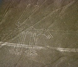
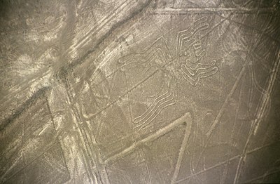
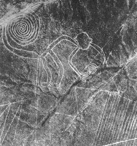
The Nazca Lines are a group of very large geoglyphs formed by depressions or shallow incisions made in the soil of the Nazca Desert in southern Peru. They were created between 500 BCE and 500 CE.

Pisco, Peru Place in Ica, Peru

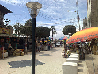
Pisco is a small city located in the Department of Ica of Peru, the capital of the Pisco Province. The city is around 9 metres above sea level. Pisco was founded in 1640, close to the indigenous emplacement of the same name. Pisco originally prospered because of its nearby vineyards and became noted for its grape brandy or pisco which was exported from its port. Pisco has an estimated population of 104,656.

Department of Arequipa Region in 8 provinces and 109 districts, Peru

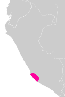
Arequipa is a department in southwestern Peru. It is bordered by the departments of Ica, Ayacucho, Apurímac and Cusco in the north, the Department of Puno in the east, the Department of Moquegua in the south, and the Pacific Ocean in the west. Its capital, also called Arequipa, is Peru's second-largest city.

Ica, Peru Place in Ica, Peru

The city of Ica is the capital of the Department of Ica in southern Peru. While the area was long inhabited by varying cultures of indigenous peoples, the Spanish conquistador Gerónimo Luis de Cabrera claimed its founding in 1563. As of the 2017 census, it had a population of over 282,407. The city suffered extensive damage and loss of life during the 2007 Peru earthquake.

Cahuachi, in Peru, was a major ceremonial center of the Nazca culture, based from 1 AD to about 500 AD in the coastal area of the Central Andes. It overlooked some of the Nazca lines. The Italian archaeologist Giuseppe Orefici has been excavating at the site for the past few decades. The site contains over 40 mounds topped with adobe structures. The huge architectural complex covers 0.6 sq. miles (1.5 km2) at 365 meters above sea level.. The American archeologist Helaine Silverman has also conducted long term, multi-stage research and written about the full context of Nazca society at Cahuachi, published in a lengthy study in 1993.

Nazca culture civilization

The Nazca culture was the archaeological culture that flourished from c. 100 BC to 800 AD beside the arid, southern coast of Peru in the river valleys of the Rio Grande de Nazca drainage and the Ica Valley. Having been heavily influenced by the preceding Paracas culture, which was known for extremely complex textiles, the Nazca produced an array of crafts and technologies such as ceramics, textiles, and geoglyphs—specifically the Nazca Lines. They also built an impressive system of underground aqueducts, known as puquios, that still function today. The Nazca Province in the Ica Region was named for this people.

Pisco Province Province in Ica, Peru

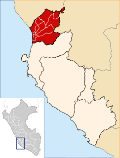
Pisco is a province of the Ica Region in Peru. Its capital is the town of Pisco, where the popular liquor of the same name originated.

Paracas National Reserve Protected area in Peru

Paracas National Reserve is a protected area located in the region of Ica, Peru and protects desert and marine ecosystems for their conservation and sustainable use. There are also archaeological remains of the Paracas culture inside the reserve.

Peruvian territory was inhabited 14,000 years ago by hunters and gatherers. Subsequent developments include the appearance of sedentary communities that developed agriculture and irrigation, and the emergence of complex socio-political hierarchies that created sophisticated civilizations, technology and monumental construction.

Chincha Alta Town in Ica, Peru

Chincha Alta is a Peruvian city located in the Ica Region. It is the capital of Chincha Province.

Nazca is a city in Peru.

Chincha Province Province in Ica, Peru

The Chincha Province is one of five provinces of the Ica Region of Peru. The capital of the province is the city of Chincha Alta.

Palpa Province Province in Ica, Peru

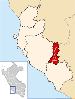
The Palpa Province is the smallest of five provinces of the Ica Region of Peru and the only landlocked province of the region. The capital of the province is the city of Palpa.

2007 Peru earthquake 8.0 Mw quake some 200 kilometers south of the capital Lima

The 2007 Peru earthquake, which measured 8.0 on the moment magnitude scale, hit the central coast of Peru on August 15 at 23:40:57 UTC and lasted for about three minutes. The epicenter was located 150 km (93 mi) south-southeast of Lima at a depth of 39 km (24 mi). The United States Geological Survey National Earthquake Information Center reported that it was a Very strong earthquake. The Peruvian government stated that 519 people were killed by the quake.

Pisco Basin

Pisco Basin is a sedimentary basin extending over 300 kilometres (190 mi) in southwestern Peru. The basin has a 2 kilometres (6,600 ft) thick sedimentary fill, which is about half the thickness of more northern foreland basins in Peru. The oldest known sediments are Eocene sandstones, while the youngest deposits date to the Pliocene. In relation to present-day topography the fill of Pisco Basin makes the upper part of the Coastal Cordillera of southern Peru, the coastal plains, the Ica-Nazca Depression and the Andean foothills.

References

Coordinates: 14°04′S75°44′W / 14.07°S 75.73°W / -14.07; -75.73