Related Research Articles
Logan County Airport is a public use airport located 2.2 nautical miles northeast of the central business district of Lincoln, a city in Logan County, Illinois, United States. It is owned by the Logan County Board. The airport is also the site of the National Weather Service Central Illinois.
Springdale Municipal Airport is a public use airport in Washington County, Arkansas, United States. It is owned by the City of Springdale and located one nautical mile (2 km) southeast of its central business district. This airport is included in the National Plan of Integrated Airport Systems for 2011–2015, which categorized it as a general aviation facility.
Beaver Island Airport is a public use airport located on Beaver Island in Charlevoix County, Michigan, United States. It is owned by St. James Township and Peaine Township. It is included in the Federal Aviation Administration (FAA) National Plan of Integrated Airport Systems for 2017–2021, in which it is categorized as a local general aviation facility.
Cheboygan County Airport is a public use airport located two nautical miles (3.7 km) west of the central business district of Cheboygan, a city in Cheboygan County, Michigan, United States. It is owned by the Cheboygan Airport Authority. It is included in the Federal Aviation Administration (FAA) National Plan of Integrated Airport Systems for 2017–2021, in which it is categorized as a basic general aviation facility. The airport is accessible from Levering Road and is close to US Highway 23.
Duplin County Airport is a county-owned, public-use airport in Duplin County, North Carolina, United States. It is located two nautical miles (4 km) northwest of the central business district of Kenansville, North Carolina. This airport is included in the National Plan of Integrated Airport Systems for 2011–2015, which categorized it as a general aviation facility.
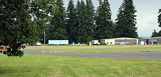
Scappoose Airport is a public use airport located one nautical mile (1.85 km) northeast of the central business district of Scappoose, in Columbia County, Oregon, United States. It is owned and operated by the Port of Columbia County, an Oregon port district and municipal corporation, on behalf of district residents. According to the FAA's National Plan of Integrated Airport Systems for 2009–2013, it is categorized as a general aviation airport.

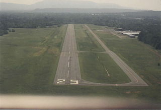
Tillamook Airport is a public use airport located 3 miles (4.8 km) south of the central business district of Tillamook, a city in Tillamook County, Oregon, United States. It is owned by the Port of Tillamook Bay. According to the FAA's National Plan of Integrated Airport Systems for 2009–2013, it is categorized as a general aviation facility.
Oswego County Airport is a county-owned, public-use airport three nautical miles (6 km) northeast of the central business district of Fulton, in Oswego County, New York, United States. The airport is located in Volney, New York. It has been designated by the Federal Aviation Administration as a general aviation reliever airport for Syracuse Hancock International Airport, located 25 miles (40 km) to the southeast.

Nampa Municipal Airport is a city-owned public airport in Nampa, in Canyon County, Idaho. The FAA's National Plan of Integrated Airport Systems for 2009–2013 called it a general aviation airport.
Monticello Municipal Airport, also known as Ellis Field, is a public-use airport located two nautical miles east of the central business district of Monticello, in Drew County, Arkansas, United States. It is owned by the City of Monticello.

Marianna Municipal Airport is an airport in Marianna, Jackson County, Florida, 5 miles (8.0 km) northeast of Downtown Marianna. The Federal Aviation Administration (FAA)'s National Plan of Integrated Airport Systems for 2009–2013 categorized it as a general aviation airport. It was formerly Graham Air Base.
Inverness Airport is a public use airport located two nautical miles (4 km) southeast of the central business district of Inverness, a city in Citrus County, Florida, United States. The airport is owned by Citrus County and contains an aviation unit of the Citrus County Sheriff's Office. It is also located next to the Citrus County Speedway.
Sandpoint Airport is a county-owned public-use airport in the northwest United States, located two nautical miles (4 km) north of the central business district of Sandpoint in Bonner County, Idaho. The airport is also known as Dave Wall Field.
New Castle Municipal Airport is a small municipal airport located in Union Township, Lawrence County, Pennsylvania serving Lawrence County, Pennsylvania, part of the Pittsburgh metropolitan area. Union Township is an outskirt of New Castle, Pennsylvania hence the name. The airport is located four nautical miles northwest of the central business district of New Castle. The airport is a public-owned airport and is controlled by the Lawrence County Airport Authority.
Beaufort Executive Airport is a county-owned, public-use airport in Beaufort County, South Carolina, United States. The airport is located on Lady's Island, 3 nautical miles southeast of the central business district of Beaufort, South Carolina. It is also known as Frogmore Intranational Airport.
Russellville Regional Airport is a city-owned public-use airport located two nautical miles (3.7 km) southeast of the central business district of Russellville, a city in Pope County, Arkansas, United States. According to the FAA's National Plan of Integrated Airport Systems for 2009–2013, it is categorized as a general aviation facility. It was formerly known as Russellville Municipal Airport.
Madison Municipal Airport is a city-owned public use airport located one nautical mile northeast of the central business district of Madison, a city in Lake County, South Dakota, United States. This airport is included in the FAA's National Plan of Integrated Airport Systems for 2009–2013, which categorized it as a general aviation facility.

Driggs–Reed Memorial Airport is a city-owned public-use airport located one nautical mile (1.85 km) north of the central business district of Driggs, a city in Teton County, Idaho, United States. This airport is included in the FAA's National Plan of Integrated Airport Systems for 2009–2013, which categorized it as a general aviation facility.
Baker Municipal Airport is a public-use airport located one nautical mile southeast of the central business district of Baker, a city in Fallon County, Montana, United States. The airport is owned by Baker City and Fallon County. It is included in the FAA's National Plan of Integrated Airport Systems for 2011–2015, which categorized it as a general aviation facility.
Price County Airport is a county owned public airport located one mile northwest of Phillips, in Price County, Wisconsin, United States. It is included in the Federal Aviation Administration (FAA) National Plan of Integrated Airport Systems for 2021–2025, in which it is categorized as a local general aviation facility.
References
- 1 2 "Airline and Airport Code Search". IATA . Retrieved 19 November 2015.
- 1 2 3 4 FAA Airport Form 5010 for GIC PDF . Federal Aviation Administration. Effective 25 August 2011.
- ↑ "Boigu Island Airport (GIC)". Aviation Safety Network . Retrieved September 28, 2011.