
Lake County is a county located in the U.S. state of Indiana. In 2020, its population was 498,700, making it Indiana's second-most populous county. The county seat is Crown Point. The county is part of Northwest Indiana and the Chicago metropolitan area, and contains a mix of urban, suburban and rural areas. It is bordered on the north by Lake Michigan and contains a portion of the Indiana Dunes. It includes Marktown, Clayton Mark's planned worker community in East Chicago.
Oak Forest is a city in Cook County, Illinois, United States. The city is out 24 miles (39 km) south-southwest of downtown Chicago in Bremen Township. Per the 2020 census, the population was 27,478.

Hammond is a city in Lake County, Indiana, United States. Located along Lake Michigan, it is part of the Chicago metropolitan area and the only city in Indiana to border Chicago. As of the 2020 census, it is the eighth-most populous city in Indiana, with 77,879 residents. It was first settled in the mid-19th century and it is one of the oldest cities of northern Lake County.

Pleasant Prairie is a village in Kenosha County, Wisconsin, United States. Located along the southwestern shoreline of Lake Michigan, Pleasant Prairie was home to 21,250 people at the 2020 census. The village is positioned directly south of the city of Kenosha, Wisconsin and directly north of the Illinois border.

The Wabash River is a 503-mile-long (810 km) river that drains most of the state of Indiana, and a significant part of Illinois, in the United States. It flows from the headwaters in Ohio, near the Indiana border, then southwest across northern Indiana turning south near the Illinois border, where the southern portion forms the Indiana-Illinois border before flowing into the Ohio River.

Indiana Dunes National Park is a national park of the United States located in northwestern Indiana managed by the National Park Service. It was authorized by Congress in 1966 as the Indiana Dunes National Lakeshore and was redesignated as the nation's 61st national park on February 15, 2019. The park runs for about 20 miles (32 km) along the southern shore of Lake Michigan and covers 15,349 acres (6,212 ha). Along the lakefront, the eastern area is roughly the lake shore south to U.S. 12 or U.S. 20 between Michigan City, Indiana, on the east and the Cleveland-Cliffs steel plant on the west. This area's conservation scheme is enhanced by the older Indiana Dunes State Park. To the west of the steel plant lies West Beach and a small extension south of the steel mill continues west along Salt Creek to Indiana 249. The western area is roughly the shoreline south to U.S. 12 between the Burns Ditch west to Broadway in downtown Gary, Indiana. In addition, there are several outlying areas, including Pinhook Bog, in LaPorte County to the east; the Heron Rookery in Porter County, the center of the park; and the Hoosier Prairie State Nature Preserve and the Hobart Prairie Grove, both in Lake County, the western end of the park.

The Kankakee River is a tributary of the Illinois River, approximately 133 miles (214 km) long, in the Central Corn Belt Plains of northwestern Indiana and northeastern Illinois in the United States. At one time, the river drained one of the largest wetlands in North America and furnished a significant portage between the Great Lakes and the Mississippi River. Significantly altered from its original channel, it flows through a primarily rural farming region of reclaimed cropland, south of Lake Michigan.
Illinois is in the midwestern United States. Surrounding states are Wisconsin to the north, Iowa and Missouri to the west, Kentucky to the east and south, and Indiana to the east. Illinois also borders Michigan, but only via a northeastern water boundary in Lake Michigan. Nearly the entire western boundary of Illinois is the Mississippi River, except for a few areas where the river has changed course. Illinois' southeastern and southern boundary is along the Wabash River and the Ohio River, whereas its northern boundary and much of its eastern boundary are straight survey lines. Illinois has a maximum north–south distance of 390 miles (630 km) and 210 miles (340 km) east-west. Its total area is 57,918 square miles (150,010 km2).
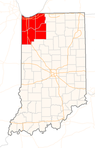
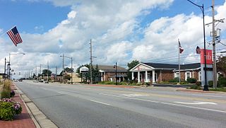
Northwest Indiana, nicknamed "The Region" after the Calumet Region, is an unofficial region of northern Indiana, United States that is located at the northwestern corner of the state. Though there is no official definition of the region, it is based on the Gary, Indiana Metropolitan Division, which comprises Jasper, Lake, Porter and Newton counties in Indiana, and the Michigan City-La Porte, IN Metropolitan Statistic Area, which comprises LaPorte, with unofficial definitions also including Starke and Pulaski counties. This region neighbors Lake Michigan and parts of it are in the Chicago metropolitan area. According to the 2020 census, the largest definition of Northwest Indiana has a population of 866,965 and is the state's second largest urban area after the Indianapolis Metropolitan Area. It is also the home of the Indiana Dunes, parts of which have been preserved through conservation efforts. The town of Ogden Dunes houses the Hour Glass, a museum showcasing the ecological and conservation efforts of O. D. Frank.

Calumet Park is a 198-acre (79-hectare) urban park in Chicago, Illinois. Providing access to Lake Michigan from the East Side neighborhood on the city's Southeast Side, the park contains approximately 0.9 miles (1.5 km) of lake frontage from 95th Street to 102nd Street, which extends to the city limits, the Illinois' border with Indiana. The park is listed on the National Register of Historic Places.

Lake Chicago was a prehistoric proglacial lake that is the ancestor of what is now known as Lake Michigan, one of North America's five Great Lakes. Formed about 13,000 years ago and fed by retreating glaciers, it drained southwest through the Chicago Outlet River.

Wolf Lake is an 804-acre (325.4 ha) lake that straddles the Indiana and Illinois state line near Lake Michigan. It is smaller than it was prior to settlement by European colonizers because of infilling for development around the edges. Despite years of environmental damage caused by heavy industries, transportation infrastructure, urban runoff and filling of wetlands, it is one of the most important biological sites in the Chicago region.

U.S. Route 12 (US 12) is a part of the United States Numbered Highway System that runs from Aberdeen, Washington, to Detroit, Michigan. In the U.S. state of Indiana, it is part of the state road system. US 12 enters the state concurrent with US 20 and US 41 in Hammond. The 46.258 miles (74.445 km) of US 12 that lie within Indiana serve as a major conduit. Some of the highway is listed on the National Highway System (NHS). Various sections are rural two-lane highway, urbanized four-lane undivided highway, and one-way streets. The easternmost community along the highway is Michiana Shores at the Michigan state line.

A boundary marker, border marker, boundary stone, or border stone is a robust physical marker that identifies the start of a land boundary or the change in a boundary, especially a change in direction of a boundary. There are several other types of named border markers, known as boundary trees, pillars, monuments, obelisks, and corners. Border markers can also be markers through which a border line runs in a straight line to determine that border. They can also be the markers from which a border marker has been fixed.

The geography of Indiana comprises the physical features of the land and relative location of U.S. State of Indiana. Indiana is in the north-central United States and borders on Lake Michigan. Surrounding states are Michigan to the north and northeast, Illinois to the west, Kentucky to the south, and Ohio to the east. The entire southern boundary is the Ohio River.

William W. Powers State Recreation Area is an Illinois state park administered by the Illinois Department of Natural Resources on 580 acres (230 ha) in the Hegewisch community area of the City of Chicago in Cook County, Illinois, United States. The area includes 419 acres (170 ha) of water in Wolf Lake that provides about 6 miles (10 km) of shoreline to fishermen. The park hosts about half a million visitors annually. The park contains numerous species, and is one of the most important biological sites in the Chicago region.

The Great Lakes Circle Tour is a designated scenic road system connecting all of the Great Lakes and the St. Lawrence River. It consists of routes for circumnavigating the lakes, either individually or collectively. It was designated by the Great Lakes Commission in 1988.

The 1872 California-Nevada State Boundary Marker marks the initial point for the 1872 survey delineation of the state line between California and Nevada. The boundary marker is a small cast iron obelisk near Verdi, Nevada. It is listed in the National Register of Historic Places.

The State Line Generating Plant was a coal-fired electrical generating station that operated from 1929 until 2012. It was located on the coast of Lake Michigan, bordering the state line separating Indiana from Illinois but within the corporate limits of Hammond, Indiana. In 2008–09, it had a year-round capacity of 515 megawatts.

Lake Kankakee formed 14,000 years before present (YBP) in the valley of the Kankakee River. It developed from the outwash of the Michigan Lobe, Saginaw Lobe, and the Huron-Erie Lobe of the Wisconsin glaciation. These three ice sheets formed a basin across Northwestern Indiana. It was a time when the glaciers were receding, but had stopped for a thousand years in these locations. The lake drained about 13,000 YBP, until reaching the level of the Momence Ledge. The outcropping of limestone created an artificial base level, holding water throughout the upper basin, creating the Grand Kankakee Marsh.
