Indiana Colony

Last updated

The Indiana Colony is the name of the cooperative who originally settled in the area known today as Pasadena, California, United States, as well as their first name for the area they settled. The group was incorporated on January 31, 1874, by Indiana residents seeking warmer weather after the exceptionally cold winter of 1872–73. [1] The settlers met in the home of Thomas Elliott, and Daniel Berry was selected to visit Southern California with a direction to find suitable land at a suitable price. [2]

Contents

Berry visited San Diego, Anaheim, San Fernando, Rancho Santa Anita and Rancho San Pascual. After meeting Judge Benjamin Eaton and Benjamin Davis "Don Benito" Wilson, he was able to negotiate the purchase of lands in the eastern part of Rancho San Pascual near the Arroyo Seco. The recession of 1873 caused a few initial investors to withdraw from the settlement plans. Berry immediately reincorporated the company into the San Gabriel Orange Grove Association, enlisting any interested parties and salvaging the purchasing power of the settlement. [3]

The nearly 4,000-acre (16 km2) property would become The Indiana Colony, the genesis of present-day Pasadena, California. [4]

Reason for moving

In 1873 the Midwest had been hit by its hardest winter in history, leading many of those in Indianapolis to long for a warmer climate and an environment where they could live among citrus groves and perennial flowers. With the laying of the Transcontinental Railroad in 1869, the idea of moving west became more possible and affordable. It was at the home of Dr. and Mrs. Thomas Elliott that a group of neighbors, including Mrs. Elliot's brother, Daniel M. Berry, first discussed the idea of going west.

Berry was a former teacher become journalist who had a great interest in his brother-in-law's granary. He was also an asthmatic and the Midwestern weather went hard on him. He contacted Harris Newmark, who had recently purchased Rancho Santa Anita, and was able to get pertinent information on the southland. Newmark even stopped by Indianapolis and gave a first-hand account of California to the Elliotts et al. From that meeting the Hoosiers formed "The California Colony of Indiana". It took little time to fill the limited roll of the organization's membership.

Next was the task of investigating the California properties.

Selection of territory

From a committee of four it was Daniel Berry who was left to set off to scout land in Southern California for the group of Indianapolis investors. He visited five regions: San Diego, Anaheim, San Fernando, Rancho Santa Anita and Rancho San Pascual. He was given a budgetary target of $5 per acre with which to negotiate.

San Diego seemed an ideal spot and the price was right, but a series of windmills would have had to be set up to pump water. The Company rejected the idea. He determined San Bernardino to be too hot. In Anaheim he didn't care for the superabundance of fleas nor the number of "musketers" (gun toters). Of San Fernando, he said the price at $2 per acre was acceptable, but the area was only good for growing grain. There was too little access to water for citrus growing. The Indianans had their hearts set on orchards. Rancho Santa Anita was the collective lands of today's Arcadia, Monrovia, Duarte, El Monte, and Baldwin Park. The property had absolutely everything required for citrus growing, but was too expensive at $20 per acre.

On September 12, 1873, Berry met Judge Benjamin Eaton, who represented Dr. John S. Griffin of the Fair Oaks Ranch (near east Altadena) on Rancho San Pascual where Berry had his first good night's sleep in years. He fell in love with Rancho San Pascual, and to keep his find a secret, he attached a cryptic name to the place as "Muscat" for the grapes that were grown so abundantly over the hillsides. [5]

Southern California Orange Grove Assoc.

The land was being offered for $10 per acre, but there was indecision between Dr. Griffin and Benjamin Wilson on dividing properties. Berry wrote Elliott requesting the money to purchase what he could of Rancho San Pascual. The mail turnaround response was two weeks; it was September 19 before the word got to Indiana. The Company decided to come closer to the asking price of Santa Anita with an offer of $15 per acre. This negotiation was never destined for success. For one, the owner Newmark was not at home; two, the N. Y. Stock Market had been struck by a panic and ruined the financial plans for the Indiana Colony.

Elliott retained a few of the original investors and forwarded only $200 as a down payment on $25,000 of Muscat property. Berry turned promoter and selectively enlisted more investors into the company under a new California incorporation, "The Southern California Orange Grove Association". [6] He sold 100 shares at $250 per share and salvaged the purchasing power of the company.

As Griffin and Wilson settled their land divisions, the association negotiated for a strip of 2,576 acres (10 km2) near the Arroyo Seco. Griffin offered an additional 1,386 acres (6 km2), which he acquired from Wilson free of charge and taxes, to the Colony as well. It was considered a gesture of good faith, but actually, it was the sloughing of what was considered to be worthless highland property that would one day become Altadena. The lower tract of land would become The Indiana Colony. [7]

Renaming the colony

The name lasted until townspeople wanted their own post office. Up to this time, the mail was being brought up from Los Angeles by one resident's son who was going to school there. Mail for the colony came to Los Angeles earmarked for "Indiana Colony," but when the community applied for a post office, the Postmaster General rejected the name Indiana Colony. Thus began the search for a new name for the town which would end up being Pasadena. [8]

See also

Related Research Articles

<span class="mw-page-title-main">Pasadena, California</span> City in Los Angeles County, California

Pasadena is a city in Los Angeles County, California, United States, 11 miles (18 km) northeast of downtown Los Angeles. It is the most populous city and the primary cultural center of the San Gabriel Valley. Old Pasadena is the city's original commercial district.

<span class="mw-page-title-main">Altadena, California</span> Unincorporated community in California, United States

Altadena is an unincorporated area and census-designated place in the Verdugo Mountains region of Los Angeles County, California, approximately 14 miles (23 km) from downtown Los Angeles, and directly north of the city of Pasadena, California. The population was 42,777 at the 2010 census, up from 42,610 at the 2000 census.

<span class="mw-page-title-main">San Gabriel Valley</span> Populated valley in Southern California, United States

The San Gabriel Valley, often referred to by its initials as SGV, is one of the principal valleys of Southern California, with the city of Los Angeles directly bordering it to the west, and occupying the vast majority of the southeastern part of Los Angeles County. Surrounding landforms and other features include the following:

<span class="mw-page-title-main">Arroyo Seco (Los Angeles County)</span> Seasonal watercourse and human settlement in US

The Arroyo Seco, meaning "dry stream" in Spanish, is a 24.9-mile-long (40.1 km) seasonal river, canyon, watershed, and cultural area in Los Angeles County, California. The area was explored by Gaspar de Portolà who named the stream Arroyo Seco as this canyon had the least water of any he had seen. During this exploration he met the Chief Hahamog-na (Hahamonga) of the Tongva Indians.

<span class="mw-page-title-main">Benjamin Davis Wilson</span> American politician from California (1811–1878)

Benjamin Davis Wilson, commonly known as Don Benito Wilson, was an American-Mexican politician, fur trapper, and ranchero of California. Born in Tennessee, Wilson eventually settled in Alta California when it was part of the Republic of Mexico, and acquired Rancho Jurupa. He became a naturalized Mexican citizen and married into a prominent Californio family.

<span class="mw-page-title-main">Los Angeles County Arboretum and Botanic Garden</span> Arboretum and botanical garden in Arcadia, California

The Los Angeles County Arboretum and Botanic Garden, 127 acres, is an arboretum, botanical garden, and historical site nestled into hills near the San Gabriel Mountains in Arcadia, California, United States. Open daily, it only closes on Christmas Day.

<span class="mw-page-title-main">Alfred Chapman</span> American politician

Alfred Beck Chapman was a Los Angeles real estate attorney and investor. He was one of the founders of the city of Orange, California.

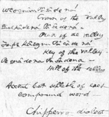
The Hahamog'na, commonly anglicized to Hahamongna and spelled Xaxaamonga in their native language, are a tribe of the Tongva people of California. Their language belongs to the Uto-Aztecan family.

Foothill Boulevard is a major road in the city and county of Los Angeles, as well as an arterial road in the city and county of San Bernardino, stretching well over 60 miles (97 km) in length, with some notable breaks along the route. Like its name implies, Foothill Boulevard runs across the foothills of the San Gabriel and San Bernardino Mountains.

<span class="mw-page-title-main">Los Angeles Terminal Railway</span>

The Los Angeles Terminal Railway, earlier known as the Pasadena Railway, and unofficially as the Altadena Railway, was a small terminal railroad line that was constructed between Altadena and Pasadena, California in the late 1880s. It was a byproduct of a land boom period and a victim of the land bust that occurred soon thereafter. It opened officially on January 31, 1888.

<span class="mw-page-title-main">Lucky Baldwin</span>

Elias Jackson "Lucky" Baldwin was "one of the greatest pioneers" of California business, an investor, and real estate speculator during the second half of the 19th century. He earned the nickname "Lucky" Baldwin due to his extraordinary good fortune in a number of business deals. He built the luxury Baldwin Hotel and Theatre in San Francisco and bought vast tracts of land in Southern California, where a number of places and neighborhoods are named after him.

<span class="mw-page-title-main">Eaton Canyon</span> Natural feature in the U.S. state of California

Eaton Canyon is a major canyon beginning at the Eaton Saddle near Mount Markham and San Gabriel Peak in the San Gabriel Mountains in the Angeles National Forest, United States. Its drainage flows into the Rio Hondo river and then into the Los Angeles River. It is named after Judge Benjamin S. Eaton, who lived in the Fair Oaks Ranch House in 1865 not far from Eaton Creek.

Rancho San Pascual, also known as Rancho el Rincón de San Pascual, was a 14,403-acre (58.29 km2) Mexican land grant in present-day Los Angeles County, California given to Juan Marine in 1834 by Mexican Governor José Figueroa. The former Rancho San Pascual land includes present-day cities of Pasadena, South Pasadena, and portions of San Marino, and the unincorporated communities of Altadena and San Pasqual.

Rancho Santa Anita was a 13,319-acre (53.90 km2) land grant in present-day Los Angeles County, California given to naturalized Scottish immigrant Hugo Reid and his Kizh people wife. Reid built an adobe residence there in 1839, and the land grant was formally recognized by Governor Pio Pico in 1845. The land grant covered all or portions of the present day cities of Arcadia, Monrovia, Sierra Madre, Pasadena and San Marino. A small portion of the rancho has been preserved as the Los Angeles County Arboretum and Botanic Garden.

<span class="mw-page-title-main">Crank House</span> Historic house in California, United States

Crank House, also known as Fair Oaks Ranch, is an 1882 Victorian style residence in Altadena, Los Angeles County, California. The house was placed on the National Register of Historic Places in 1997 for its association with the early settlement of Altadena. (site #97000751). The house has notably featured in films such as Hocus Pocus, Matilda, Scream 2 and Catch Me If You Can.

<span class="mw-page-title-main">Scripps Hall (California)</span> Historic house in California, United States

Scripps Hall, also known now as the Pasadena Waldorf School, is a large American Craftsman or Arts and Crafts style house located in the foothills of the San Gabriel Mountains, in Altadena, California, United States. It was built in 1904 as the central feature of the Scripps Estate, and is listed on the National Register of Historic Places.

<span class="mw-page-title-main">Hahamongna, California</span>

Hahamongna and Hahamog-na are two historic Tongva village sites. They are located in the Verdugo Mountains of Southern California and bear the name of the local band of indiginous Tongva, "Hahamog'na." The sites are located in present-day Pasadena and Glendale in Los Angeles County, California. Hahamongna was one of the largest Tongva villages in the greater San Fernando Valley area, along with Cahuenga, Tujunga, and Siutcanga.

Pasadena is a city in Los Angeles County, California, United States. Founded in 1874 and incorporated in 1886, the city is famous for its colorful history and for the hosting of both the Tournament of Roses Parade and the annual Rose Bowl game football game. It is also the home of the world-renowned California Institute of Technology (Caltech) and Jet Propulsion Laboratory (JPL)

<span class="mw-page-title-main">John Strother Griffin</span> American physician

John Strother Griffin (1816–1898) was a surgeon attached to the General Stephen W. Kearney expedition from New Mexico to California, a landowner and founder of East Los Angeles and a member of the Common Council of the city of Los Angeles, where he was one of the first university-trained physicians to settle.

<span class="mw-page-title-main">Corona Founders Monument</span> California Historic Landmark

The Corona Founders Monument is a monument built in 1936 to the founding fathers of the City of Corona in the Riverside County, California. The monument was designated a California Historic Landmark (No.738) on June 6, 1960. The monument is in the Corona City Park in the 100 block of 6th Street of Corona, California. The founding fathers at first called the city South Riverside after the company they started the South Riverside Land and Water Company.

References

  1. Nicholls, Natalie Keinonen (2012). "Blizzards to Blooms". jmhs.peacework.us. Archived from the original on March 5, 2024. Retrieved 2024-03-05.
  2. Saavedra, Yvette J. (2019-06-04). "Pasadena, California, Was Born in Indiana During the Cold, Damp Winter of 1872". Zócalo Public Square. Archived from the original on March 5, 2024. Retrieved 2024-03-05.
  3. Creason, Glenn (July 20, 2016). "Pasadena Was Founded by "Colonists" from Indiana". Los Angeles Magazine. Archived from the original on March 5, 2024. Retrieved 2024-03-05.
  4. Wood, John Windell (1917). Pasadena, California, historical and personal; a complete history of the organization of the Indiana colony, its establishment on the Rancho San Pascual and its evolution into the city of Pasadena. The Internet Archive. John Wendell Wood.
  5. Kyle, Dreams of the Pioneers, published by the Pasadena Museum of History, 1983.
  6. Madison, James H. (1990). "Taking the Country Barefooted: The Indiana Colony in Southern California". California History. 69 (3): 236–249. doi:10.2307/25591551. ISSN   0162-2897 via JSTOR.
  7. McCloskey. 6 Horses and 10 Head, Boys' Club of Pasadena, 1971.
  8. Reid, Hiram Alvin (1895). History of Pasadena. The Internet Archive. Pasadena, California: Pasadena History Company.