
Fillmore County is a county in the U.S. state of Minnesota. As of the 2020 census, the population was 21,228. Its county seat is Preston. Fillmore County is included in the Rochester metropolitan area.
The Minnesota Department of Transportation oversees transportation by all modes including land, water, air, rail, walking and bicycling in the U.S. state of Minnesota. The cabinet-level agency is responsible for maintaining the state's trunk highway system, funding municipal airports and maintaining radio navigation aids, and other activities.

The Stillwater Bridge is a vertical-lift bridge crossing the St. Croix River between Stillwater, Minnesota, and Houlton, Wisconsin. It formerly connected Minnesota State Highway 36 and Wisconsin Highway 64. Around 18,000 vehicles crossed the bridge daily. The new St. Croix Crossing bridge crossing the St. Croix river valley to the south of Stillwater replaced its purpose, having opened to highway traffic on August 2, 2017, leaving the Stillwater Lift Bridge to be preserved and to be converted to bicycle/pedestrian use.

Cascade River State Park is a state park near the northeastern tip of Minnesota, USA. The park is in a rocky and rugged location where the Cascade River descends to meet Lake Superior. It has many different types of wildlife including various birds and mammals.

Minnesota State Highway 16 is an 87.671-mile-long (141.093 km) two-lane highway in southeast Minnesota, which runs from its interchange with Interstate Highway 90 in Dexter and continues east to its eastern terminus at the Wisconsin state line concurrent with U.S. Highways 14 and 61 outside La Crescent just west of La Crosse, Wisconsin.

The St. Croix Boom Site is a historic and scenic wayside on the St. Croix River in Stillwater Township, Minnesota, United States. It commemorates the location of a critical log boom where, from 1856 to 1914, timber from upriver was sorted and stored before being dispatched to sawmills downstream. The site was developed as a roadside park along Minnesota State Highway 95 in the 1930s. In 1966 it was designated a National Historic Landmark for its national significance in the theme of industry. It was nominated for being the earliest, most important, and longest serving of the log storage and handling operations that supported Minnesota's major logging industry. Virtually no traces remain of the site's original buildings and structures.

Minnesota State Highway 250 is a 9.479-mile-long (15.255 km) highway in southeast Minnesota, which runs from its intersection with State Highway 16 in Lanesboro and continues north to its northern terminus at its intersection with State Highway 30 in Arendahl Township. MN 250 passes through Lanesboro, Holt Township, and Arendahl Township.

Kern Bridge or Yaeger Bridge crossed the Le Sueur River in Blue Earth County in the U.S. state of Minnesota. It was built in 1873 using a bowstring through truss design by the Wrought Iron Bridge Company. It was 183.5 feet (56 m) long and carried a local road. It was listed on the National Register of Historic Places in 1980 as Minnesota's only bowstring arch truss bridge and oldest road bridge still in use. However, it was closed to vehicle traffic in 1991.

This is a list of the National Register of Historic Places listings in Fillmore County, Minnesota. It is intended to be a complete list of the properties and districts on the National Register of Historic Places in Fillmore County, Minnesota, United States. The locations of National Register properties and districts for which the latitude and longitude coordinates are included below, may be seen in an online map.

Bridge 5757 or the Fond du Lac Culvert is a historic bridge in the Fond du Lac neighborhood of Duluth, Minnesota, United States. It was built in 1937 to carry Minnesota State Highway 23 over Mission Creek. It is a double-span culvert built using a modular, corrugated iron product called "multi-plate", with granite headwalls. The creek flows through two 20-foot (6 m) metal culverts that are 115 feet (35 m) wide. The bridge was part of a 0.75-mile (1.2 km) section of Highway 23 built as a wide, shaded, parkway-like divided highway known as Veterans' Evergreen Memorial Highway.

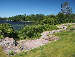
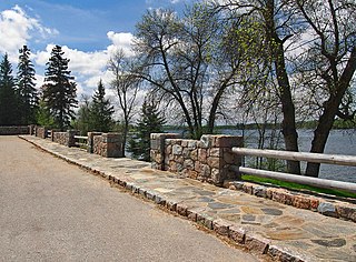
The Stillwater Overlook is a scenic overlook in Oak Park Heights, Minnesota, United States, just south of the city limits of Stillwater, near the junction of Minnesota State Highway 36 and Minnesota State Highway 95. The overlook was listed on the National Register of Historic Places in 2007 for having state-level significance in politics/government and landscape architecture. It was nominated as a leading example of the early wayside rests developed by the Minnesota Department of Highways Roadside Development Division, as well as for its sophisticated and well-preserved National Park Service rustic architecture, and for being an important work of Minnesota landscape architect Arthur R. Nichols.
Arthur R. Nichols was a landscape architect who practiced in New York City and Minnesota in a long career from 1902 through 1960. He was a very productive landscape architect who was instrumental in bringing the field of landscape architecture to Minnesota.

The Craigie Flour Mill Historical Marker is a wayside rest on Minnesota State Highway 78 in Otter Tail County, Minnesota. The site was designed by landscape architect Arthur R. Nichols and built by the National Youth Administration and the Minnesota Highway Department. The style is National Park Service Rustic architecture.

Park Road 4 (PR 4) is a 15.5-mile-long (24.9 km) park road in western Burnet County, Texas that travels through and provides access to Longhorn Cavern State Park and Inks Lake State Park. The highway connects State Highway 29 (SH 29) to U.S. Route 281 (US 281). The highway was constructed between 1934 and 1942 by the Civilian Conservation Corps (CCC), Works Progress Administration (WPA) and Texas State Highway Department (TSHD).

Pine-Hickory Lakes Roadside Parking Area is a wayside rest located along U.S. Highway 169 in Farm Island Township, Aitkin County, Minnesota. It straddles both sides of the highway just north of where it passes between Little Pine Lake on the west and Hickory Lake on the east. It is one of the largest wayside rests developed by the Minnesota Highway Department during the New Deal, at 35 acres (14 ha). Arthur R. Nichols, collaborating with engineer Harold E. Olson, designed the rest area in the National Park Service rustic style. The wayside rest was listed on the National Register of Historic Places in May 2016.

The St. Alban's Bay Culvert is a historic bridge in Garrison Township, Minnesota, United States. It carries the four-lane U.S. Route 169 (US 169) over the head of a stream flowing out of Mille Lacs Lake. It was built from 1938 to 1939 as part of a major New Deal project to create a scenic parkway along the lakeshore. The bridge was listed on the National Register of Historic Places in 2015 as the St. Alban's Bay Culvert at Mille Lacs Lake for having state-level significance in the themes of architecture and politics/government. It was nominated for being a well-preserved example of the Minnesota Highway Department's earliest scenic improvements, its rare status as a highway bridge built by the department's Roadside Development Division—a unit usually focused on overlooks and waysides—and for its fine National Park Service rustic design.
The Kenney Lake Overlook is a historic roadside park in Garrison Township, Minnesota, United States. Adjacent to the southbound lane of Minnesota State Highway 18 (MN 18), the two-acre (0.8 ha) site provides a parking area and an overlook of a small lake. The wayside was built in 1939 as part of a major New Deal project to create a scenic parkway along the shore of nearby Mille Lacs Lake. The Mille Lacs Highway Development Plan was the largest highway improvement project in the state constructed by the Civilian Conservation Corps (CCC). The Kenney Lake Overlook was listed on the National Register of Historic Places in 2015 for having state-level significance in the themes of landscape architecture and politics/government. It was nominated for being a key component of a major highway improvement project, for representing the work of the Veterans Division of the CCC and the earliest scenic improvements of the Minnesota Highway Department (MHD), and for its fine National Park Service rustic design.

The Garrison Concourse is a roadside park on Mille Lacs Lake in Garrison, Minnesota, United States. The site consists of a wide parking area and scenic overlook projecting out into the lake, plus landscaped parkland along the shore in both directions. It was built from 1936 to 1939 as the centerpiece of the Mille Lacs Highway Development Plan, a major New Deal project to create a scenic parkway along the lakeshore. The park was listed on the National Register of Historic Places in 2013 for having state-level significance in the themes of landscape architecture and politics/government. It was nominated for being the premiere structure of the most extensive roadside development project undertaken by the Minnesota Highway Department and the Civilian Conservation Corps, and for its blend of formalism and National Park Service rustic design.

The Reads Landing Overlook is a scenic overlook on U.S. Route 61 in Pepin Township, Minnesota, United States. It was built from 1939 to 1940 as a New Deal project to provide motorists with a scenic view of Lake Pepin. It was designed by landscape architect Arthur R. Nichols and constructed by the National Youth Administration. The overlook was listed on the National Register of Historic Places in 2004 for its state-level significance in the themes of landscape architecture and politics/government. It was nominated for exemplifying the early highway waysides built in Minnesota with federal work relief aid, and for exemplifying as well National Park Service rustic style and the work of Nichols.
The Orr Roadside Parking Area is a roadside park on U.S. Route 53 in Orr, Minnesota, United States. It was built from 1935 to 1938 as a New Deal project to provide motorists with recreational access to Pelican Lake. It was designed by landscape architect Arthur R. Nichols and constructed by the Civilian Conservation Corps in collaboration with the Minnesota Department of Highways. The overlook was listed on the National Register of Historic Places in 2002 for its state-level significance in the themes of landscape architecture and politics/government. It was nominated for exemplifying the early highway waysides built in Minnesota with federal work relief aid, and for exemplifying National Park Service rustic style and the work of Nichols.


