International District, Albuquerque, New Mexico

Last updated
International District
Neighborhood of Albuquerque
Tewa Lodge, Albuquerque NM.jpg
The Tewa Lodge on Central Ave.
Coordinates: 35°4′21″N106°34′06″W / 35.07250°N 106.56833°W / 35.07250; -106.56833
CountryUnited States
State New Mexico
County Bernalillo
City Albuquerque
Government
[1]
  City CouncilNichole Rogers
   State House G. Andrés Romero (D)
Debra M. Sariñana (D)
Kay Bounkeua (D)
   State Senate Antoinette Sedillo Lopez (D)
Mimi Stewart (D)
   U.S. House Melanie Stansbury (D)
Area
  Total3.87 sq mi (10.0 km2)
Population
 (2010) [2]
  Total29,796
  Density7,699/sq mi (2,973/km2)
ZIP Code
87108 [1]
Area code 505

The International District is a neighborhood in southeast Albuquerque, New Mexico. It is centered on Central Avenue, the historic alignment of U.S. Route 66, and contains the New Mexico State Fairgrounds. The community is one of the most diverse areas of the city and is home to a large number of international restaurants and grocery stores, [3] as well as the city's "Little Saigon" Vietnamese enclave. [4] It is also one of the poorest areas in the city and has an extremely high violent crime rate. Although re-branded by city officials as the International District in 2009, Albuquerque residents continue to refer to the neighborhood by its longtime nickname, The War Zone.

Contents

Geography

As defined by the city of Albuquerque's Sector Development Plan, the International District consists of the 3.9-square-mile (10 km2) area bounded by San Mateo Boulevard, Lomas Boulevard, Wyoming Boulevard, and Gibson Boulevard. This area includes the communities of Fair West, La Mesa, South San Pedro, Trumbull Village, and Elder Homestead, as well as Expo New Mexico, the site of the New Mexico State Fair. [5] The district was similarly defined in resolutions passed by the Albuquerque City Council and New Mexico State Senate, although Siesta Hills was not explicitly mentioned. [6] [7] The neighborhood's main commercial thoroughfares are Central Avenue, Zuni Road, and Gibson Boulevard (east-west) and San Pedro Drive and Louisiana Boulevard (north-south). As Central is the dividing axis of Albuquerque's quadrant system, the International District is split between the Northeast and Southeast quadrants.

Demographics

As of the 2010 Census, the International District had a total population of 29,796. [2]

The racial makeup of the neighborhood was: [8]

Hispanic or Latino people of any race made up 60% of the population.

In 2016, an estimated 41% of neighborhood residents were below the federal poverty level. [9]

History

Before World War II, the area that now makes up the International District was mostly unpopulated apart from the small community of La Mesa and a few other scattered homesteads, some owned by African Americans. [10] The New Mexico State Fairgrounds were built there in 1938. After the war, Albuquerque experienced a major population boom, with many new residents attracted by government jobs at Kirtland Air Force Base and Sandia National Laboratories. As the city's population soared from 35,499 to 201,189 between 1940 and 1960, neighborhoods in the eastern part of the city like the International District were rapidly developed. [11] Meanwhile, a business district filled with motels, diners, and service stations developed along Central Avenue, which was designated as part of the famous U.S. Route 66 in 1937.

In the 1960s, the area struggled economically after Kirtland transferred much of its personnel to on-base housing and Interstate 40 took most of the long-haul traffic away from Route 66. The International District's abundance of low-cost motels and apartments made it a landing place for immigrants and other newcomers to the city, including refugees from Southeast Asia (especially Vietnam) and later Central America. [12] However, the neighborhood also attracted a significant amount of criminal activity, which led to its notoriety as the "War Zone" by the late 1980s. [13] A 1991 article from the Albuquerque Journal described East Central as "a loose-jointed carnival of sex, drugs and booze" with drug dealers and prostitutes operating openly. [14] Violent crime was a problem as well, with 34 homicides recorded in southeast Albuquerque in 1996 (more than half of the city's total) and 11 in Trumbull Village alone. [15] In 1997, the city put up barricades in the neighborhood to make it harder for criminals to get in and out. [16]

Eventually, thanks in part to efforts by neighborhood residents, the crime rate decreased and the barricades were removed. In 2009, residents who resented the War Zone name persuaded city leaders to officially re-brand the area as the International District, highlighting its diverse community rather than crime. [17] The first International Festival was held later that year. [12] Despite these changes, crime has continued to be an issue in the neighborhood. In 2017, the Journal reported that it was "the most violent place in the city in the past three years and is home to both victims and suspects." Between 2014 and 2016, 10% of addresses in the neighborhood reported a violent crime, and 25% reported a property crime. One business in the neighborhood reported 98 violent crimes during that period. [18] In 2018, the International District was ranked as the worst neighborhood in New Mexico for the health and well-being of young children. [19]

Points of interest

Two sites in the International District are listed on the National Register of Historic Places: the National Humane Alliance Animal Fountain, which sits in front of the headquarters of Animal Humane New Mexico on Virginia St., and the Tewa Lodge on Central Ave. Another historic motel, the La Mesa Motel, is no longer standing. Other notable sites include the New Mexico State Fairgrounds (Expo New Mexico), Tingley Coliseum, the Bank of the West Tower, once New Mexico's tallest building, and the Cal-Linn Building, which was the original headquarters of Microsoft. [20] The neighborhood is also known for its assortment of international restaurants and grocery stores.

Education

Albuquerque Public Schools operates two elementary schools, Emerson and La Mesa, and two middle schools, Wilson and Van Buren, in the International District. Students in some parts of the neighborhood also attend Hawthorne, Mark Twain, Sandia Base, Wherry, Whittier, and Zia Elementary Schools, and Hayes Middle School. High school students in the International District attend Highland High School. [21]

Transportation

ABQ Ride operates public transit in the neighborhood, including the 11 Lomas, 16 Broadway-University-Gibson, 31 Wyoming, 34 San Pedro Commuter, 66 Central, 96 Crosstown Commuter, 97 Zuni, 98 Wyoming Commuter, 140/141 San Mateo, 157 Montaño-Uptown-Kirtland, 217 Downtown-Kirtland Limited, 222 Rio Bravo-Sunport-Kirtland, 766 Rapid Ride Red Line, and 777 Rapid Ride Green Line city bus routes. [22] The Albuquerque Rapid Transit (ART) bus rapid transit system also serves the International District via its San Mateo, San Pedro, Louisiana, and Wyoming stations.

Related Research Articles

<span class="mw-page-title-main">Albuquerque, New Mexico</span> City in New Mexico, United States

Albuquerque, also known as ABQ, Burque, and the Duke City, is the most populous city in the U.S. state of New Mexico. Founded in 1706 as La Villa de Alburquerque by Santa Fe de Nuevo México governor Francisco Cuervo y Valdés, and named in honor of Francisco Fernández de la Cueva, 10th Duke of Alburquerque and Viceroy of New Spain, it served as an outpost on El Camino Real linking Mexico City to the northernmost territories of New Spain.

<span class="mw-page-title-main">Tucumcari, New Mexico</span> City in the United States

Tucumcari is a city in and the county seat of Quay County, New Mexico, United States. The population was 5,278 at the 2020 census. Tucumcari was founded in 1901, two years before Quay County was established.

<span class="mw-page-title-main">Albuquerque International Sunport</span> Airport in Albuquerque, New Mexico, United States

Albuquerque International Sunport, locally known as the Sunport, is the primary international airport serving the U.S. state of New Mexico, particularly the Albuquerque metropolitan area and the larger Albuquerque–Santa Fe–Las Vegas combined statistical area. It handles around 5.4 million passengers annually and over 400 flights daily. ABQ is located in Bernalillo County, between the Rio Grande and the Sandia Mountains, east of Old Town and Barelas, 3 miles (5 km) southeast of downtown, south of the University of New Mexico and directly to the west of Sandia National Laboratories and Kirtland Air Force Base.

City Heights is a dense urban community in central San Diego, California, known for its ethnic diversity. The area was previously known as East San Diego. City Heights is located south of Mission Valley and northeast of Balboa Park.

Albuquerque Public Schools (APS) is a school district based in Albuquerque, New Mexico. Founded in 1891, APS is the largest of 89 public school districts in the state of New Mexico. In 2022 it had a total of 143 schools with some 70,000 students, making it one of the largest school districts in the United States. APS operates 88 elementary, 5 K-8, 28 middle, 20 high, 31 charter, and alternative schools. They also own the radio station KANW and co-own the TV stations KNME-TV and KNMD-TV along with the University of New Mexico.

Oxnard Field was the first airport in Albuquerque, New Mexico. It served as the home of commercial aviation in Albuquerque from 1928 to 1929 and remained in use for other purposes until 1948. The field was located on Albuquerque's East Mesa, east of the present site of Albuquerque International Sunport.

<span class="mw-page-title-main">U.S. Route 66 in New Mexico</span> Historic highway in the United States

The historic U.S. Route 66 ran east–west across the central part of the state of New Mexico, along the path now taken by Interstate 40 (I-40). However, until 1937, it took a longer route via Los Lunas, Albuquerque, and Santa Fe, now roughly New Mexico State Road 6 (NM 6), I-25, and US 84. Large portions of the old road parallel to I-40 have been designated NM 117, NM 118, NM 122, NM 124, NM 333, three separate loops of I-40 Business, and state-maintained frontage roads.

<span class="mw-page-title-main">Mesa del Sol</span> Subdivision of Albuquerque in the United States

Mesa del Sol is an uncompleted 16,000-acre (6,500 ha) mixed-use master planned community in Albuquerque, New Mexico. Mesa del Sol, a 12,900-acre (5,200 ha) mixed-use community, is located on Albuquerque's South Mesa. By combining job creation with sustainable urban community planning, Mesa del Sol will represent a blend of natural resources, economic objectives, and social amenities in a community with a forward-looking and distinct sense of place. Mesa del Sol is a sustainable city with plans to build 37,000 homes on 4,400 acres (1,800 ha) of residential property and 18,000,000 square feet (1,700,000 m2) of office, industrial, and retail space. 

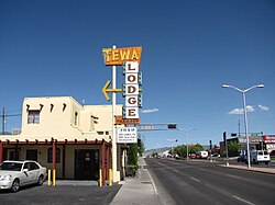
Central Avenue is a major east–west street in Albuquerque, New Mexico, which historically served as the city's main thoroughfare and principal axis of development. It runs through many of Albuquerque's oldest neighborhoods, including Downtown, Old Town, Nob Hill, and the University of New Mexico area. Central Avenue was part of U.S. Route 66 from 1937 until the highway's decommissioning in 1985 and also forms one axis of Albuquerque's house numbering system. It was also signed as Business Loop 40 until the early 1990s when ownership of Central Avenue was transferred from the New Mexico State Highway Department to the City of Albuquerque.

<span class="mw-page-title-main">Silver Hill, Albuquerque</span> United States historic place

Silver Hill is a neighborhood in southeast Albuquerque, New Mexico, which is significant as one of the oldest developments on the city's East Mesa. Much of the neighborhood is included in the Silver Hill Historic District, which was listed on the National Register of Historic Places in 1986. The neighborhood is roughly bounded by Central Avenue, Yale Boulevard, Central New Mexico Community College, and Presbyterian Hospital. The northeast corner of the neighborhood borders the University of New Mexico campus.

<span class="mw-page-title-main">Barelas</span> Neighborhood of Albuquerque in New Mexico, United States

Barelas is an inner-city neighborhood of Albuquerque, New Mexico, located immediately south of Downtown. It consists of the triangular area bounded by Coal Avenue, the BNSF railroad tracks, and the Rio Grande. Originally a separate village, it was absorbed into Albuquerque during the railroad-fueled growth of the 1880s but still retains a distinct identity. The settlement was formally established in 1662, predating even Old Town as the oldest neighborhood in the city. Although it was long one of Albuquerque's most economically distressed areas, Barelas has seen significant development since the opening of the National Hispanic Cultural Center in 2000 and may be starting to experience gentrification.

<span class="mw-page-title-main">Nob Hill, Albuquerque, New Mexico</span> Neighborhood of Albuquerque in Bernalillo, New Mexico, United States

Nob Hill is a neighborhood in Albuquerque, New Mexico, United States, consisting of a commercial district along Central Avenue and surrounding residential areas. Located just east of the University of New Mexico, the neighborhood was developed between about 1925 and 1950 and has since become a popular tourist and shopping destination. Known for its eclectic mix of mostly locally owned businesses, Nob Hill has been described as "the heart of Albuquerque's Route 66 culture and also its hippest, funkiest retail and entertainment district". The neighborhood is named after Nob Hill in San Francisco, California.

The following is a timeline of the history of the city of Albuquerque, New Mexico, US.

The history of Albuquerque, New Mexico dates back up to 12,000 years, beginning with the presence of Paleo-Indian hunter-gatherers in the region. Gradually, these nomadic people adopted a more settled, agricultural lifestyle and began to build multi-story stone or adobe dwellings now known as pueblos by 750 CE. The Albuquerque area was settled by the Tiwa people beginning around 1250. By the 1500s, there were around 20 Tiwa pueblos along a 60-mile (97 km) stretch of the middle Rio Grande valley. The region was visited by Spanish conquistadores beginning with the expedition of Francisco Vázquez de Coronado in 1540–41, and began to be settled by Spanish colonists after the expedition of Juan de Oñate in 1598. By 1680, 17 Spanish estancias were reported along the Camino Real in the Albuquerque area.

<span class="mw-page-title-main">Homelessness in New Mexico</span> New Mexico, US

Homelessness is a serious issue throughout the state of New Mexico. Through a demographic examination it becomes evident that New Mexico has a high proportion of ethnographies that are currently and historically socioeconomically disadvantaged. Native Americans as a proportion of the US population represent the second highest amongst all States with only Alaska having a higher ratio, while it also has a large Hispanic population. Homelessness is a direct cause from an individual not being able to provide themselves with the most basic of necessities to maintain a healthy life hence having a higher proportion of individuals in poverty places a greater risk of an individual becoming homeless.

<span class="mw-page-title-main">Martineztown-Santa Barbara</span> Neighborhood of Albuquerque

Martineztown-Santa Barbara is a neighborhood in central Albuquerque, New Mexico, immediately northeast of Downtown. Originating as a small farming village in the 1850s, it is one of the city's oldest neighborhoods and retains a distinct character, with winding streets, irregular lots, and adobe vernacular buildings reminiscent of other old Hispanic communities in northern New Mexico.

<span class="mw-page-title-main">Huning Highlands</span> Neighborhood of Albuquerque

Huning Highlands, also known as EDo or East Downtown, is an inner-city neighborhood in Albuquerque, New Mexico, directly east of Downtown. It is a mostly residential area known for its high concentration of Victorian and early 20th-century houses and is listed on the National Register of Historic Places as the Huning Highlands Historic District. There is also a commercial district along the main thoroughfares, Central Avenue and Broadway Boulevard. Huning Highlands was developed starting in 1880 and is named for Franz Huning, a prominent businessman at the time.

<span class="mw-page-title-main">South Broadway, Albuquerque</span> Neighborhood of Albuquerque in Bernalillo, New Mexico, United States

South Broadway is an inner-city neighborhood in Albuquerque, New Mexico, located southeast of Downtown. The neighborhood developed between the 1890s and early 1900s and has a housing stock consisting mainly of smaller Victorian homes and bungalows. It was historically a diverse working-class neighborhood and the center of the city's African American community. Along with other New Mexican cities such as Clovis and Hobbs, the neighborhood is one of the centers of Black American culture and history in New Mexico.

San Jose is a neighborhood in southern Albuquerque, New Mexico. It was originally a separate village but was absorbed into the city in the 20th century. San Jose was first settled as a Hispanic farming community in the mid-1800s but transitioned to a working-class urban neighborhood after the arrival of the railroad in 1880. The neighborhood includes a mix of residential and industrial properties with a commercial district centered on Broadway Boulevard.

<span class="mw-page-title-main">Downtown Neighborhood, Albuquerque</span> Neighborhood of Albuquerque

The Downtown Neighborhood is a neighborhood in Albuquerque, New Mexico, located between Downtown and Old Town. It is sometimes known as the Fourth Ward based on Albuquerque's former system of political wards. The neighborhood is a mostly residential area consisting largely of single-family dwellings in various sizes and styles constructed between the 1880s and 1940s. There is also a commercial district along Central Avenue which has been branded since 2017 as West Downtown.

References

  1. 1 2 "Advanced Map Viewer". City of Albuquerque. Retrieved April 25, 2018.
  2. 1 2 "2010 Census Summary File 1, Table P1". U.S. Census Bureau. Retrieved April 25, 2018.
  3. McKay, Dan (February 3, 2009). "Introducing the "International District"". Albuquerque Journal. Retrieved April 25, 2018.
  4. "Culture & Heritage: Asian American". Visit Albuquerque. Retrieved April 25, 2018.
  5. "International District Zone Boundary Map" (PDF). City of Albuquerque Planning Department. Retrieved April 20, 2018.
  6. "New Mexico Senate Joint Memorial 24-2009" (PDF). New Mexico State Legislature. Retrieved May 30, 2018.
  7. "Albuquerque City Council Resolution 09-203". CABQ Legistar. Retrieved May 30, 2018.
  8. "2010 Census Summary File 1, Table P9". U.S. Census Bureau. Retrieved April 25, 2018.
  9. "2012–2016 American Community Survey 5-Year Estimate, Table B17021". U.S. Census Bureau. Retrieved April 25, 2018.
  10. Snyder, Christy; Glanzberg, Joel; Mang, Nicholas (2015). Huston, Allegra (ed.). The International District (PDF). Story of Place Institute. Retrieved April 24, 2018.
  11. Kammer, David. "Albuquerque 1945-1959". New Mexico Office of the State Historian. Retrieved September 29, 2017.
  12. 1 2 Keller, Tim (July 4, 2014). "History of Albuquerque's International District". Green Fire Times. Retrieved April 24, 2018.
  13. Rosales, Glen (June 18, 1989). "Drug Arrest Goads Residents To Reclaim 'War Zone'". Albuquerque Journal. Retrieved April 24, 2018 via Newspapers.com.
  14. Brewer, Steve (August 4, 1991). "East Central: Caught in the Middle". Albuquerque Journal. Retrieved April 24, 2018 via Newspapers.com.
  15. Belshaw, Jim (May 8, 1998). "Single Digit Measurement". Albuquerque Journal. Retrieved April 24, 2018 via Newspapers.com.
  16. Jones, Jeff (March 19, 1997). "Neighborhood's Barricades Designed To Keep Criminals Out". Albuquerque Journal. Retrieved April 25, 2018 via Newspapers.com.
  17. "'International District' Official". Albuquerque Journal. March 6, 2009. Retrieved April 25, 2018 via Newspapers.com.
  18. "Southeast crime zone has 6.7% of city's population, 27% of murders". Albuquerque Journal. August 14, 2017. Retrieved April 25, 2018.
  19. Linthicum, Leslie (February 18, 2018). "This is home: Stories from one of Albuquerque's toughest neighborhoods". Las Cruces Sun-News. Retrieved April 25, 2018.
  20. Metcalf, Richard (September 14, 2006). "Microsoft's ABQ Cradle Is on the Market". Albuquerque Journal. Retrieved April 25, 2018.
  21. "School Locations & Districts". City of Albuquerque. Retrieved April 26, 2018.
  22. "Bus Routes & Schedules". City of Albuquerque. Retrieved April 25, 2018.