Interstate 74 in Iowa

Last updated

I-74 (IA).svg

Interstate 74

Interstate 74 in Iowa
I-74 highlighted in red
Route information
Maintained by Iowa DOT
Length5.36 mi [1]  (8.63 km)
ExistedAugust 30, 1968 [2] –present
HistoryUnder construction 1968–1974
NHSEntire route
Major junctions
West endI-80.svg I-80 in Davenport
Major intersections
East endI-74.svgUS 6.svg I-74  / US 6 at the Mississippi River
Location
Country United States
State Iowa
Counties Scott
Highway system
US 71.svg US 71 US 75.svg US 75

Interstate 74 (I-74) is the central freeway through the Iowa Quad Cities. It roughly divides Davenport to the west and Bettendorf to the east. The Interstate Highway begins at an interchange with I-80 at the northeastern edge of Davenport and continues into Illinois at the Mississippi River by crossing the I-74 Bridge. The freeway was built in stages during the late 1960s and early 1970s.

Contents

The northern half of the Interstate was built atop farmland in northeastern Davenport, while the southern half was built near the existing U.S. Highway 6 (US 6) corridor through Bettendorf. After the approaches to the I-74 Bridge were rebuilt for Interstate traffic, it was completed and opened to traffic on November 26, 1974.

The Iowa Department of Transportation (Iowa DOT) and the Illinois Department of Transportation (IDOT) are planning a major reconstruction project along I-74. The seven-mile-long (11 km) corridor will be widened from four lanes to six. A new river crossing will be built to replace the aging bridges. Eastbound motorists on I-80 wishing to use I-74 east of the Quad Cities are suggested to use I-80 east around town for this reason.

Route description

I-74 begins at a trumpet interchange with I-80 on the northern edge of Davenport where it heads to the south. From I-80 to the East 67th Street overpass, the freeway is surrounded by farmland on either side. South of the overpass, it passes a residential area to the east and a commercial area to the west. The East 53rd Street exit provides access to shopping centers on both sides of the Interstate. [3]

Continuing south between East 53rd Street and Spruce Hills Drive, I-74 goes through an area of sparse development. What businesses there are, have frontages on either Elmore Avenue to the west or Utica Ridge Road to the east; the backs of these businesses abut the freeway. [3] At the Spruce Hills Drive exit, US 6 joins from the west. Nearly 0.33 miles (0.53 km) to the west, Spruce Hills Drive becomes Kimberly Road, which carries US 6 through Davenport until it intersects I-280 on the western edge of the Quad Cities. [4]

South of Spruce Hills Drive, I-74 runs parallel to the eastern leg of Kimberly Road, which turns south at its intersection with Spruce Hills Drive. The freeway curves slightly to the southeast and enters Bettendorf. It crosses Duck Creek and meets Middle Road at a diamond interchange. [4]

As I-74 and US 6 head down a hill toward the Mississippi River, a series of exit and entrance ramps connect the freeway to US 67, which runs northbound along State Street and southbound along Grant Street. The Interstate passes over US 67 and railroad tracks belonging to the Dakota, Minnesota and Eastern Railroad on an elevated highway, which serves as the approach to the I-74 Bridge over the Mississippi River. Despite the singular name, the crossing is two twin bridges which each carry one direction of traffic to and from Moline, Illinois. [4]

I-74 crosses the Mississippi River via the twin spans of the I-74 Bridge. 2022 I-74 Bridge 04.jpg
I-74 crosses the Mississippi River via the twin spans of the I-74 Bridge.

History

An Interstate bisecting the Quad Cities was planned as early as 1955 Davenport, Iowa 1955 Yellow Book.jpg
An Interstate bisecting the Quad Cities was planned as early as 1955

I-74 was part of the original plans for building Iowa's Interstate system. [5] It would form the Iowa leg of a planned freeway from the Quad Cities to Cincinnati, Ohio. [6] Its route through the Quad Cities closely resembles the path drawn up in the mid-1950s. [4] [7]

In the Iowa Quad Cities, I-74 opened in three segments beginning on August 30, 1968. On that day, the northernmost three miles (4.8 km), from I-80 to US 6, opened to traffic. The new freeway was built atop farmland west of Utica Ridge Road in the northeastern part of Davenport. [8] The next section was built adjacent to the north–south portion of Kimberly Road, which then carried US 6 through Bettendorf. The segment ended where the Interstate lined up with the older street. The eastbound exit and westbound entrance ramps at Kimberly Road now provide access to and from US 67. The middle section opened in 1971. [2]

Another three years passed before the freeway was completed and opened to traffic. The twin spans of the I-74 Bridge had to be retrofitted to connect to the Interstate. The Iowa-bound bridge was built as a Works Progress Administration project in 1934–1935 and the Illinois-bound bridge was 24 years later. [9] Prior to Interstate construction, the I-74 Bridge terminated at State Street, the northbound lanes of US 67, in Bettendorf. To prevent traffic bottlenecks, traffic was prohibited from making left turns onto and off of the bridges. As a result, loop ramps diverted traffic onto Gilbert Street, one block south of State Street, which curved back to State Street at both ends thus allowing traffic to make the necessary left turns. [10]

Construction of the Interstate meant eliminating the at-grade intersections with State and Grant streets. I-74 was built as the elevated highway from the bridges to a new overpass at Kimberly Road. The connections were completed and opened to traffic on November 26, 1974, [2] and dedicated to Moline on December 11, 1975. [11] In the late 1980s, a project was undertaken to widen 53rd Street to four lanes across northern Davenport. It included replacing an overpass of I-74 with an interchange. [12]

The old I-74 bridge spans I-74 Bridge, Iowa-Illinois Border Crossing - panoramio.jpg
The old I-74 bridge spans

In 2005, Iowa DOT and IDOT began planning a new bridge to replace the aging I-74 Bridge. The Iowa-bound bridge opened in 1935; and the Illinois bridge in 1958. [9] In addition to replacing the bridges, the scope of the bi-state coalition's plan includes updating seven miles (11 km) of I-74 mainline and interchanges from 53rd Street in Davenport to the Avenue of the Cities in Moline. [13] They identified the traffic needs of the corridor and found they would be satisfied by a true-arch, tied-arch, or cable-stayed bridge. After public input and consideration of construction costs and aesthetics, the Departments of Transportation, in August 2006, recommended building two twin, true-arch, basket-handle bridges. [14] US Senator Mark Kirk of Illinois suggested charging a toll upon motorists who use the new bridges to help pay for their construction. However, a 1998 study, which researched all river crossing options to replace the bridges, deemed new tolls were not viable. [15]

In addition to the new river crossing, the mainline of I-74 between 53rd Street in Davenport and the Avenue of the Cities in Moline will be widened from a four-lane freeway to six lanes; additional lanes will be picked up and dropped in selected locations. The new bridge itself will be eight lanes; three through lanes and one auxiliary lane that will enter on one side of the river and exit on the other. [16] In downtown Bettendorf, the connection to US 67 was simplified. Previously, State and Grant streets were a one-way couplet through Bettendorf and a network of ramps and city streets formed the interchange. At the new I-74 interchange, State Street was rerouted to briefly join Grant Street so only four ramps were needed to make full connections between I-74 and US 67. [17]

Construction along the corridor has already been completed at the 53rd Street interchange. A partial cloverleaf interchange was added in each direction to allow traffic to enter I-74 without making left turns at its intersection with 53rd Street. This phase of construction ended around December 2012. Officials from Iowa and Illinois, including Iowa Governor Kim Reynolds and Illinois Governor Bruce Rauner, were scheduled to be on hand to break ground on the new bridge on June 26, 2017. [18] On either side of the arch, a 200-foot-tall (61 m) tower was built to hold the arch into place before the keystone segment was installed. [19] The Iowa-bound keystone was installed on May 5, 2020, after which 108 hangers that support the road deck were strung from the arch. [20] At 72 feet (22 m) wide, the westbound span is wider than both of the older bridges combined. It opened to traffic on November 20, 2020; both directions of I-74 traffic were placed onto the new bridge. [21] Construction on the Illinois-bound arch began shortly after. The eastbound keystone was installed on May 5, 2021. [22]

Exit list

The entire route is in Scott County.

Locationmi [23] kmExit [4] DestinationsNotes
Davenport 0.000–
0.316
0.000–
0.509
I-80.svg I-80  Des Moines, Chicago Western end of I-74; I-80 exit 298
1.5272.457153rd Street Hamilton Technical College
2.8964.6612West plate.svg
US 6.svg
US 6 west (Spruce Hills Drive, Kimberly Road)
Western end of US 6 overlap
Bettendorf 3.9026.2803Middle Road, Locust Street
4.9447.9574US 67.svg US 67 (Grant Street, State Street) – Riverfront
Mississippi River 5.3998.689 I-74 Bridge; Iowa–Illinois state line
East plate blue.svg
I-74.svg
East plate.svg
US 6.svg
I-74 east / US 6 east Peoria
Continuation into Illinois
1.000 mi = 1.609 km; 1.000 km = 0.621 mi

Related Research Articles

<span class="mw-page-title-main">Quad Cities</span> Metropolitan Statistical Area in the United States

The Quad Cities is a region of cities in the U.S. states of Iowa and Illinois: Davenport and Bettendorf in southeastern Iowa, and Rock Island, Moline and East Moline in northwestern Illinois. These cities are the center of the Quad Cities metropolitan area, a region within the Mississippi River Valley, which as of 2013 had a population estimate of 383,781 and a Combined Statistical Area (CSA) population of 474,937, making it the 90th-largest CSA in the nation.

<span class="mw-page-title-main">Interstate 74</span> Interstate Highway in the Midwest and in North Carolina

Interstate 74 (I-74) is an Interstate Highway in the Midwestern and Southeastern United States. Its western end is at an interchange with I-80 in Davenport, Iowa ; the eastern end of its Midwest segment is at an interchange with I-75 in Cincinnati, Ohio. The major cities that I-74 connects to include Davenport, Iowa; Peoria, Illinois; Bloomington, Illinois; Champaign, Illinois; Indianapolis, Indiana; and Cincinnati, Ohio. I-74 also exists as several disconnected sections of highways in North Carolina.

<span class="mw-page-title-main">U.S. Route 67</span> Highway in the United States

U.S. Route 67 is a major north–south U.S. highway which extends for 1,560 miles (2,511 km) in the Central United States. The southern terminus of the route is at the United States-Mexico border in Presidio, Texas, where it continues south as Mexican Federal Highway 16 upon crossing the Rio Grande. The northern terminus is at U.S. Route 52 in Sabula, Iowa. US 67 crosses the Mississippi River twice along its routing. The first crossing is at West Alton, Missouri, where US 67 uses the Clark Bridge to reach Alton, Illinois. About 240 miles (390 km) to the north, US 67 crosses the river again at the Rock Island Centennial Bridge between Rock Island, Illinois, and Davenport, Iowa. Additionally, the route crosses the Missouri River via the Lewis Bridge a few miles southwest of the Clark Bridge.

<span class="mw-page-title-main">U.S. Route 6</span> Numbered Highway in the United States

U.S. Route 6 (US 6) or U.S. Highway 6 (US 6), also called the Grand Army of the Republic Highway, honoring the American Civil War veterans association, is a main route of the United States Numbered Highway System. While it currently runs east-northeast from Bishop, California, to Provincetown, Massachusetts, the route has been modified several times. The highway's longest-lasting routing, from 1936 to 1964, had its western terminus at Long Beach, California. During this time, US 6 was the longest highway in the country.

The Avenue of the Saints is a 563-mile-long (906 km) highway in the Midwestern United States that connects St. Louis, Missouri, and St. Paul, Minnesota.

<span class="mw-page-title-main">U.S. Route 150</span> Highway in the Midwestern United States

U.S. Route 150 is a 571-mile (919 km) long northwest–southeast United States highway, signed as east–west. It runs from U.S. Route 6 outside of Moline, Illinois to U.S. Route 25 in Mount Vernon, Kentucky.

<span class="mw-page-title-main">Interstate 88 (Illinois)</span> Tolled Interstate in Illinois

Interstate 88 (I-88) is an Interstate Highway in the US state of Illinois that runs from an interchange with I-80 near Silvis and Moline to an interchange with I-290 and I-294 in Hillside, near Chicago. I-88 is 140.60 miles (226.27 km) long. This route is not contiguous with I-88 in New York. Since 2010, most of I-88 has been part of the Chicago–Kansas City Expressway. The highway also runs through the cities of Aurora, Naperville, DeKalb, and Dixon. East of Rock Falls, the route is a part of the Illinois Tollway system.

<span class="mw-page-title-main">Interstate 280 (Iowa–Illinois)</span> Highway in Illinois and Iowa

Interstate 280 (I-280) is an auxiliary Interstate Highway that makes up the western and southern portions of the beltway around the Quad Cities of Illinois and Iowa. The freeway starts at I-80 near Davenport, Iowa, and ends at I-80 near Colona, Illinois; its eastern part runs concurrent with I-74 to return to I-80. I-280 forms the southern part of a circle around the Quad Cities as well as forming part of a bypass for US Route 61 (US 61) around Davenport. This road is 26.98 miles (43.42 km) long.

<span class="mw-page-title-main">Interstate 235 (Iowa)</span> Highway in Iowa

Interstate 235 (I-235) in Iowa is an auxiliary Interstate Highway that runs just north of downtown Des Moines through the heart of the Des Moines metropolitan area. I-235 runs from the junction of I-35 and I-80 in West Des Moines to the separation of the same two Interstates in Ankeny. The highway is approximately 14 miles (23 km) long.

<span class="mw-page-title-main">I-74 Bridge</span> Bridges across the Mississippi River between Iowa and Illinois

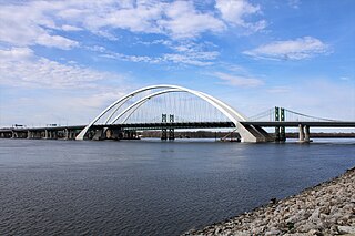
The Interstate 74 Bridge, officially known as the Iowa-Illinois Memorial Bridge, and often called The Twin Bridges, or the I-74 Bridge, are basket-handle, through arch twin bridges that carry Interstate 74 across the Mississippi River and connect Bettendorf, Iowa, and Moline, Illinois. It is located near the geographic center of the Quad Cities.

<span class="mw-page-title-main">U.S. Route 6 in Illinois</span> Segment of American highway

U.S. Route 6 (US 6) in the state of Illinois is an east–west arterial surface road that runs 179.88 miles (289.49 km) from the city of Moline in the Quad Cities area to Lansing at the Indiana state line.

<span class="mw-page-title-main">Interstate 74 in Illinois</span> Highway in Illinois

Interstate 74 (I-74) in the US state of Illinois is a major northwest–southeast Interstate Highway that runs across the central portion of the state. It runs from the Iowa state line at the Mississippi River near the city of Rock Island and runs southeast to the Indiana state line east of Danville, a distance of 220.34 miles (354.60 km). The highway runs through the major cities of Champaign, Bloomington, Peoria, and Moline.

<span class="mw-page-title-main">Interstate 80 in Illinois</span> Highway in Illinois

Interstate 80 (I-80) is a part of the Interstate Highway System that runs from San Francisco, California, to Teaneck, New Jersey. I-80 enters Illinois from Iowa in the west, southwest of Rapids City, and runs generally eastward through East Moline, LaSalle, and Joliet, before entering Indiana in Lansing. The Interstate runs for approximately 163.52 miles (263.16 km) through the state.

<span class="mw-page-title-main">U.S. Route 6 in Iowa</span> Section of U.S. Highway in Iowa

U.S. Highway 6 (US 6) is an east–west United States Numbered Highway which runs 322 miles (518 km) across the U.S. state of Iowa. The route is signed in places as the Grand Army of the Republic Highway. Like all state highways in Iowa, it is maintained by the Iowa Department of Transportation. The route begins at the Missouri River crossing at Council Bluffs. From there, it travels east through Oakland and Atlantic. North of Atlantic, the highway overlaps Interstate 80 (I-80) until De Soto. Between De Soto and Adel, the highway overlaps US 169 before splitting off to the east toward Des Moines. Through the Des Moines area, the highway runs about one mile (1.6 km) north or south of the I-35/I-80 corridor.

<span class="mw-page-title-main">Interstate 80 in Iowa</span> Highway in Iowa

Interstate 80 (I-80) is a transcontinental Interstate Highway in the United States, stretching from San Francisco, California, to Teaneck, New Jersey. In Iowa, the highway travels west to east through the center of the state. It enters the state at the Missouri River in Council Bluffs and heads east through the southern Iowa drift plain. In the Des Moines metropolitan area, I-80 meets up with I-35 and the two routes bypass Des Moines together. On the northern side of Des Moines, the Interstates split and I-80 continues east. In eastern Iowa, it provides access to the University of Iowa in Iowa City. Northwest of the Quad Cities in Walcott is Iowa 80, the world's largest truck stop. I-80 passes along the northern edge of Davenport and Bettendorf and leaves Iowa via the Fred Schwengel Memorial Bridge over the Mississippi River into Illinois.

<span class="mw-page-title-main">Special routes of U.S. Route 61</span> Highway system

Several special routes of U.S. Route 61 exist in the states of Louisiana, Mississippi, Missouri, and Iowa.

<span class="mw-page-title-main">U.S. Route 67 in Iowa</span> Highway in Iowa

U.S. Highway 67 (US 67) is a U.S. Highway in extreme eastern Iowa. The route begins in Davenport at the Rock Island Centennial Bridge where it crosses the Mississippi River and ends at an intersection with US 52 and Iowa Highway 64 (Iowa 64) west of Sabula. It passes through Bettendorf, Le Claire, and Clinton. Except for Folletts, every community which US 67 enters sits along the Mississippi River. As such, most of the route is part of the Great River Road, an All-American Road.

<span class="mw-page-title-main">U.S. Route 61 in Iowa</span> U.S. Highway in Iowa

U.S. Highway 61 (US 61) is a United States Highway that serves eastern Iowa. It enters the state from Missouri near Keokuk with US 136. North of Keokuk, it is overlapped by US 218 for a few miles. It the follows the course of the Mississippi River past Montrose and Fort Madison. It meets US 34 at Burlington. It passes through Wapello and bypasses Muscatine and Blue Grass on its way toward Davenport. There, it follows Interstate 280 (I-280) and I-80 around the Quad Cities. North of Davenport, it follows a freeway north toward DeWitt where it meets US 30. The highway continues north through Maquoketa and reaches the Dubuque area. There it is joined by US 151 and briefly by US 52. The two highways enter the downtown area on an expressway. Due to the proximity of the Mississippi River and railroad tracks that lie between, the routes have an indirect junction with US 20. The two highways leave the state and enter Wisconsin about one-half mile (800 m) north of the Illinois–Wisconsin state line.

The Big X is the junction of three Interstate Highways, I-74, I-80, and I-280, near Colona, Illinois. The cloverleaf interchange is particularly confusing for I-74 and I-80 traffic because someone wishing to stay on either route must exit their highway to connect to the other highway.

References

  1. Starks, Edward (January 27, 2022). "Table 1: Main Routes of the Dwight D. Eisenhower National System of Interstate and Defense Highways". FHWA Route Log and Finder List. Federal Highway Administration . Retrieved December 25, 2023.
  2. 1 2 3 Completion Map of Interstate System (PDF) (Map). Iowa Department of Transportation. January 1, 1982. Archived from the original (PDF) on September 29, 2011. Retrieved July 26, 2011.
  3. 1 2 Google (August 1, 2011). "Interstate 74 in Iowa" (Map). Google Maps . Google. Retrieved August 1, 2011.
  4. 1 2 3 4 5 Quad Cities inset (PDF) (Map). Iowa Department of Transportation. 2011. Retrieved July 25, 2011.
  5. Iowa Department of Transportation (June 2006). "Iowa's Interstate Highway System" (PDF). Inside. p. 20. Retrieved August 1, 2011.
  6. Official Route Numbering for the Nation System of Interstate and Defense Highways (Map). Cartography by Public Roads Administration. American Association of State Highway Officials. August 15, 1957. Retrieved August 1, 2011.
  7. Official Yellow Book map of the Quad Cities (Map). Cartography by Public Roads Administration. Public Roads Administration. 1955. Retrieved August 1, 2011.
  8. Iowa State University. "Iowa Geographic Map Server". 1960s USDA aerial photos. Scott County. Retrieved July 27, 2011.
  9. 1 2 Dispatch/Argus staff (2005). "Mississippi Bridge Timeline". The Dispatch / The Rock Island Argus . Progress 2005. Retrieved July 25, 2011.
  10. Iowa State University. "Iowa Geographic Map Server". 1960s USDA aerial photos. Bettendorf. Retrieved July 26, 2011.
  11. Gaul, Alma (October 6, 2019). "The dedication". Quad-City Times . p. B1. Retrieved July 17, 2021. Newspapers.com
  12. Grau, Scott (October 30, 1988). "I-74–53rd Street projects gear up". Quad-City Times . p. B1. Retrieved July 17, 2021 via Newspapers.com.
  13. Iowa Department of Transportation. "I-74 Corridor Overview" . Retrieved July 25, 2011.
  14. Iowa Department of Transportation (August 2006). "Recommended Bridge Type" . Retrieved July 25, 2011.
  15. Lemmon, Dustin (April 14, 2011). "I-74 bridge toll should be considered, leaders say". Quad-City Times . Davenport, Iowa. Retrieved July 27, 2011.
  16. Iowa Department of Transportation (January 2005). "I-74 Iowa-Illinois Corridor — Preferred alternative" . Retrieved July 27, 2011.
  17. Watt, Anthony (March 14, 2016). "Building a bridge". The Rock Island Argus . pp. A1–A2. Retrieved July 17, 2021 via Newspapers.com. Open Access logo PLoS transparent.svg
  18. Tibbetts, Ed (June 16, 2017). "Two governors to attend I-74 event". Quad-City Times . p. A1. Retrieved July 18, 2021 via Newspapers.com. Open Access logo PLoS transparent.svg
  19. Ickes, Barb (February 10, 2019). "Great heights". Quad-City Times . pp. B1–B3. Retrieved July 18, 2021 via Newspapers.com. Open Access logo PLoS transparent.svg
  20. Ickes, Barb (May 24, 2020). "Arch work continues for next span of Interstate 74 project". Quad-City Times. p. A8. Retrieved July 18, 2021 via Newspapers.com. Open Access logo PLoS transparent.svg
  21. Ickes, Barb (November 12, 2020). "Take a sneak peek at our new I-74 bridge". Quad-City Times . p. A1. Retrieved July 18, 2021 via Newspapers.com. Open Access logo PLoS transparent.svg
  22. Loewy, Tom (May 6, 2021). "Spectators "wouldn't miss" I-74 milestone". Quad-City Times . p. A1. Retrieved July 18, 2021 via Newspapers.com. Open Access logo PLoS transparent.svg
  23. "Road Network (Portal)" (ESRI shapefile). Ames: Iowa Department of Transportation. April 9, 2021. Retrieved April 13, 2021.
Template:Attached KML/Interstate 74 in Iowa
KML is from Wikidata
I-74.svg Interstate 74
Previous state:
Terminus
Iowa Next state:
Illinois