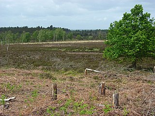
Ouse Washes is a linear 2,513.6-hectare (6,211-acre) biological Site of Special Scientific Interest stretching from near St Ives in Cambridgeshire to Downham Market in Norfolk. It is also a Ramsar internationally important wetland site, a Special Protection Area for birds, a Special Area of Conservation and a Nature Conservation Review site, Grade I. An area of 186 hectares between March and Ely is managed by the Wildlife Trust for Bedfordshire, Cambridgeshire and Northamptonshire and another area near Chatteris is managed by the Royal Society for the Protection of Birds. The Wildfowl & Wetlands Trust manages another area near Welney.

A meadow is an open habitat or field, vegetated by grasses, herbs, and other non-woody plants. Trees or shrubs may sparsely populate meadows, as long as these areas maintain an open character. Meadows can occur naturally under favourable conditions, but are often artificially created from cleared shrub or woodland for the production of hay, fodder, or livestock. Meadow habitats, as a group, are characterized as "semi-natural grasslands", meaning that they are largely composed of species native to the region, with only limited human intervention.

The Top End of Australia's Northern Territory is a geographical region encompassing the northernmost section of the Northern Territory, which aside from the Cape York Peninsula is the northernmost part of the Australian continent. It covers a rather vaguely defined area of about 245,000 km² behind the northern coast from the Northern Territory capital of Darwin across to Arnhem Land with the Indian Ocean on the west, the Arafura Sea to the north, and the Gulf of Carpentaria to the east, and with the almost waterless semi-arid interior of Australia to the south, beyond the huge Kakadu National Park.

Yala (යාල) National Park is the most visited and second largest national park in Sri Lanka, bordering the Indian Ocean. The park consists of five blocks, three of which are now open to the public. There are also two adjoining parks, Kumana National Park or 'Yala East' and Lunugamvehera National Park. The blocks have individual names, such as Palatupana. It is situated in the southeastern region of the country, in the Southern Province and Uva Province. The park covers 979 square kilometres (378 sq mi) and is located about 300 kilometres (190 mi) from Colombo. Yala was designated as a wildlife sanctuary in 1900, along with Wilpattu, designated in 1938, as the first two designated national parks in Sri Lanka. The park is best known for its variety of wildlife and is important conservation of Sri Lankan elephants, Sri Lankan leopards and aquatic birds.

Te Wāhipounamu is a World Heritage Site in the south west corner of the South Island of New Zealand.

Rangelands are grasslands, shrublands, woodlands, wetlands, and deserts that are grazed by domestic livestock or wild animals. Types of rangelands include tallgrass and shortgrass prairies, desert grasslands and shrublands, woodlands, savannas, chaparrals, steppes, and tundras. Rangelands do not include forests lacking grazable understory vegetation, barren desert, farmland, or land covered by solid rock, concrete and/or glaciers.

Keoladeo National Park or Keoladeo Ghana National Park is a famous avifauna sanctuary in Bharatpur, Rajasthan, India, that hosts thousands of birds, especially during the winter season. Over 350 species of birds are known to be resident. It is also a major tourist centre with scores of ornithologists arriving here in the hibernal season. It was declared a protected sanctuary in 1971 and established as a national park on 10 March 1982. Because of its exceptional avian biodiversity, in 1985 Keoladeo National Park was also declared a UNESCO World Heritage Site.

The wildlife of Zambia refers to the natural flora and fauna of Zambia. This article provides an overview, and outline of the main wildlife areas or regions, and compact lists of animals focusing on prevalence and distribution in the country rather than on taxonomy. More specialized articles on particular groups are linked from here.

The Aammiq Wetland is the largest remaining freshwater wetland in Lebanon, a remnant of much more extensive marshes and lakes that once existed in the Bekaa Valley. It has been designated an Important Bird Area in the Middle East, is included in the Directory of Wetlands in the Middle East, was declared Ramsar Convention site number 978 in 1999, and most recently (2005) was designated, with Al Shouf Cedar Nature Reserve, a “Biosphere reserve” by UNESCO.
Lake Galilee is a semi-arid salt lake in the locality of Galilee, Barcaldine Region, within the Desert Uplands area of Central West Queensland, Australia. The lake is about 36 kilometres long, up to 12.5 kilometres wide and covers approximately 25,700 hectares.

The Souss-Massa National Park is a 33,800 hectare national park on the Atlantic coast of Morocco which was created in 1991. It lies between Agadir to the north and Sidi Ifni to the south and its centre is at 9°40'W 30°5'N. The estuary of the Oued Souss is the northern limit of the park, and that of the Oued Massa is near the southern end. 30,000 ha of land near Aglou, south of the park, is also included in the site because it is sometimes used as a feeding area by the northern bald ibis. The habitat is grazed steppe with dunes, beaches and wetlands. The soil is mainly sandy with some rockier areas.

Woolmer Forest is a 1,298.5-hectare (3,209-acre) biological Site of Special Scientific Interest south of Bordon in Hampshire and West Sussex. It is also a Special Area of Conservation and part of the Wealden Heaths Phase II Special Protection Area. Two areas are Nature Conservation Review sites, Grade I.

The Paroo-Darling National Park is a protected national park that is located in the Far West region of New South Wales, in eastern Australia. The 178,053-hectare (439,980-acre) national park spans two distinct regions in the outback area. This region covers the arid catchments of the Paroo River and the Paroo-Darling confluence to the south.

Chefchaouen is a province in the Moroccan economic region of Tanger-Tetouan-Al Hoceima.

The Walpole Wilderness Area is a group of conservation reserves on the south coast of Western Australia. The area includes vast tracts of jarrah, red tingle and karri forests surrounding granite peaks, rivers, heathlands, and wetlands. Coastal features include inlets and sandy beaches, sheer cliffs and the Southern Ocean.
Livingstone is a national park and state conservation area located 30 kilometres (19 mi) south of Wagga Wagga and 10 kilometres (6.2 mi) east of Mangoplah, in the South West Slopes region of south western New South Wales.

The Yanga National Park is a newly formed national park, located near the township of Balranald in south- western New South Wales. It covers an area of 66,734 hectares which includes 1,932 hectares of Yanga Nature Reserve, and has a frontage of 170 kilometres (110 mi) on the Murrumbidgee River. It is largely located in the Lower Murrumbidgee Floodplain, which is included on A Directory of Important Wetlands in Australia because of its importance as a breeding site for waterbirds when flooded.

The California coastal sage and chaparral is a Mediterranean forests, woodlands, and scrub ecoregion located in southwestern California and northwestern Baja California (Mexico). It is part of the larger California chaparral and woodlands ecoregion.

Murtnaghurt Lagoon, also known as Murtnaghurt Swamp or Lake Murtnaghurt, is a shallow, ephemeral wetland west of the town of Barwon Heads on the southern coast of the Bellarine Peninsula in Victoria, Australia. It comprises two enclosed depressions, elongated west-east and separated by a low ridge. The wetland is about 2 kilometres (1.2 mi) in length, and up to 600 metres (2,000 ft) wide, with 4.5 kilometres (2.8 mi) of shoreline enclosing an area of 81 hectares. It is connected by a narrow 2.7 kilometres (1.7 mi) palaeochannel extending from the lagoon northwards to the main tidal channel of the lower Barwon River.

Alentejo is a geographical, historical, and cultural region of south–central and southern Portugal. In Portuguese, its name means "beyond the Tagus river" (Tejo).


