This article needs additional citations for verification .(July 2008) |
Isa | |
|---|---|
LGA and town | |
 Interactive map of Isa | |
 Isa | |
| Coordinates: 13°12′1″N6°24′26″E / 13.20028°N 6.40722°E | |
| Country | |
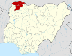
| State | Sokoto State |
| Government | |
| • Local Government Chairman | Shareef Abubakar Kamarawa [1] |
| Area | |
• Total | 2,158 km2 (833 sq mi) |
| Population (2006 Census) | |
• Total | 146,103 |
| Time zone | UTC+1 (WAT) |
| 3-digit postal code prefix | 842 |
| ISO 3166 code | NG.SO.IS |
Isa is a town and Local Government Area of Sokoto state, Nigeria. It shares borders with Shinkafi in Zamfara State, Goronyo and Sabon Birni from west and north respectively in Sokoto and the Republic of Niger in the east.[ citation needed ]
It has an area of 2,158 km2 and a population of 146,103 at the 2006 census. [2]
The postal code of the area is 842. [3]
The Isa LGA is made up of the capital town of Isa and other towns and villages such as Turba, Bafarawa (birthplace of former Sokoto State governor and 2007 presidential candidate Attahiru Bafarawa). Historically, the area was a part of the ancient kingdom of Gobir and is inhabited by members of the Gobirawa and Fulani ethnic groups.[ citation needed ]