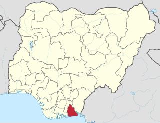
Akwa Ibom is a state in the South-South geopolitical zone of Nigeria. It borders Cross River State to the east, Rivers State and Abia State to the west and north-west, and the Atlantic Ocean to the south. The state takes its name from the Qua Iboe River which bisects the state before flowing into the Bight of Bonny. Akwa Ibom was split from Cross River State in 1987. The state has 31 local government areas, and its capital is Uyo.

Owerri is the capital city of Imo State in Nigeria, set in the heart of Igboland. It is also the state's largest city, followed by Orlu, Okigwe and Ohaji/Egbema. Owerri consists of three Local Government Areas namely Owerri Municipal, Owerri North and Owerri West. It has an estimated population of 1,401,873 as of 2016 and is approximately 100 square kilometres (40 sq mi) in area. Owerri is bordered by the Otamiri River to the east and the Nworie River to the south. The Owerri Slogan is Heartland. It is also called the Las Vegas of Africa, due to the night life of the city and the numerous hotels, casino and leisure parks all over the city.
Arochukwu Local Government Area, sometimes referred to as Arochuku or Aro Oke-Igbo, is the third largest local government area in Abia State in southeastern Nigeria and homeland of the Igbo subgroup, Aro people.
Ihiala is a city in Nigeria, located in the southern part of Anambra State and within the region known as Igboland. It has long served as the local administrative capital of Ihiala Local Government Area. The Local Government Area has a population of about 430,800.

Orlu is the second-largest city in Imo State South East (Nigeria)|South East]], Nigeria, with a population of 420,600. It has a long history as the headquarters for the Organisation of African Unity (OAU) and humanitarian relief agencies during the Nigeria-Biafra Civil War. The city houses the Nigerian headquarters of the British Cheshire Home. It is the second most developed city after Owerri in Imo state.
Orodo is an Igbo community in Mbaitoli local government area of Imo State, Nigeria. It is situated between Owerri city and Orlu town. Orodo has borders with Ogwa, Mbieri, Afara, Ifakala, Umuaka, Amurie Omanze and Amandugba. Also, the current Mbaitoli Local Government Headquarters is significantly located at a part of Orodo called Ofekata. The community said to have seven road junction, in the center of the community called nkwo-orodo. The roads are: Ubaha-Eze road, Ahaba road, Amaukwu road, Umuonyahu road, Amaku road, Ofekata road and Eziama road.
Umunoha is a town in southeastern Nigeria near the city of Owerri. It is an Igbo town. Umunoha is south of Eziama Obiato and Afara communities; and is North and Northeast of Ogbaku, Azara Obiato and Ejemekwuru communities; and is north and northwest of Ifakala and Afara communities. It is served by the great east-west road, the Port-Harcourt-Lagos Highway. Umunoha is about thirteen kilometers from Owerri, the Imo State capital. It is a small, compact but thickly populated community with a projected 1997 population of twenty-five thousand people.
Umundugba is a town in Isu Local Government Area of Imo State, Nigeria, and is the headquarters of Isu LGA.
Awgu, the headquarters of Awgu Local Government Area (LGA) in Enugu State, Nigeria, and the Headquarters of Awgu Catholic Diocese. The Catholic Cathedral is said to resemble a space ship when viewed with Google Earth. The town is also the Orientation Training Centre for National Youth Service corps members posted to Enugu State. Geographically, Awgu LGA is located approximately between latitudes 06 00’ and 06 19’ North of the Equator and longitudes 07 23’ and 07 35’ East of the Greenwich Meridian. Awgu LGA is bounded in the north by Udi and Nkanu West LGAs, in the west by Oji River LGA, Aninri LGA and Ivo LGA of Ebonyi State in the East, and shares borders with Umunneochi L.G.A of Abia State in the south. Awgu LGA boasts of Mgbowo as the community with the highest number of Professors with over 80 professors in Mgbowo alone.

Orsu is a local government area (LGA) and tribe in the Imo State of Nigeria. Orsu is also the name of the dialect of this people. They are an Igbo sub-group located west of Orlu, north of Oguta and in the general areas around Oru East, Oru West, Ihiala, Nnewi south and Oguta LGAs. Orsu LGA is made up of several autonomous communities including Ihitenansa, Amaruru, Amazu, Amaebu, Amannachi, Awo-Idemili, Asaa Ubirielem, Eziawa, Umuhu Okabia, Orsu Ihiteukwa, Okwu Ufuruaku, Okwu Amaraihe, and Okwu Etiti.

Echie administratively known as Etche is an indigenous Igbo group found in the Niger Delta region of Nigeria. Presently, its people make up Etche and Omuma, two of the 23 Local Government Areas of Rivers State they can also be found in Ngor Okpala L.G.A and Omuma town both in Imo state. They are part of the 13 federal constituencies representing River State in Nigeria's National Assembly and part of the Rivers East Senatorial District. Its people are mostly farmers, and they speak the Etche dialect of the Igbo language family.
Shelleng is a Local Government Area (LGA) of Adamawa State, North-east Nigeria.
Ikwuano is a Local Government Area of Abia State, Nigeria. Its headquarters is in Isiala Oboro. The name 'Ikwuano' etymologically indicates that there are four different ancient kingdoms that make up the community called Ikwuano. These include Oboro, Ibere, Ariam/Usaka and Oloko.

Njaba is a Local Government Area of Imo State, Nigeria. Its headquarters is located in the town of Nnenasa. It has an area of 84 km2 and a population of 143,485 at the 2006 census. The 2011 density projection is 2,004.5 inhabitants/km2. The postal code of the area is 474.

Nkwerre is one of the Local Government Areas in Imo State, South-East, Nigeria. It is situated in Nkwerre town where the name of the local government area was derived. Its population was placed at 80,270 from the 2006 population census with an area of 38.447 km. It is known for its thick vegetation which is supposed to prevent soil erosion however, it is erosion prone area.
Kajuru is a local government area in southern Kaduna State, Nigeria. Its also headquarters is in the town of Kajuru. The local government is located on longitude 9° 59'N and 10° 55'N and latitude 7° 34'E and 8° 13'E, with an area of 2,229 km2.
Kauru is a Local Government Area in southern Kaduna State, Nigeria. The area is 3,186 km2. Its headquarters are in the town of Kauru. The postal code of the area is 811.
The historical origin of Ekwe is based on oral myth and legend of tradition of common ancestors passed from generation to generation. According to this oral tradition -"Nnamike Onuoma", the founder of the Ekwe community had two sons -Ekwe and Okwudor. Okwudor later separated from his brother and settled at the other side of the Njaba River and founded the Okwudor community. Ekwe stayed put in the area, which is now known as Ekwe.[1]
The Isu people are the largest group of the Igbo people of Nigeria. Isuama, in which the purest Igbo is said to be spoken, is to be found the heart of the Igbo nationality; consequently it is quite reasonable to look among its people for the original fountain-head from which all the other clans have sprung. This inference too is supported not only by the purity of the language, but by this right of dispensing or rather of confer-ring royalty which is undoubtedly the prerogative of the Nri or N'shi people. In the pre-colonial era, the Igbo people were protected from external invasion by the dense forests of the region, which also had the effect of encouraging diversity. Thus as warriors the neighboring Oratta (Uratta) people looked down on the Isu people, who were traders.
Amandugba is a town in the Isu Local Government Area in Imo State, Nigeria.


