Ngor Okpala | |
|---|---|
 | |
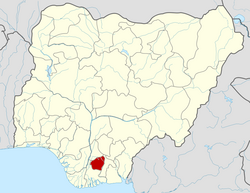
| Country | Nigeria |
| State | Imo State |
| Government | |
| • Representative | Obinna Egu |
| • Local Government Chairman | Chika Ibekwe [1] |
| Area | |
• Total | 217 sq mi (561 km2) |
| Population (2006) | |
• Total | 159,932 |
| Time zone | UTC+1 (WAT) |
 | |
Ngor Okpala is a Local Government Area in Imo State located in the eastern part of Nigeria. It is headquartered in Umuneke Ngor, and is said to have originated from Ama-Asaa. It is bounded by Ihiagwa, Owerri and Umuahia, and connects to Abia and Rivers states respectively. With a land area of 561 km², it is the largest local government area in Imo State. The current executive chairman is Chika Ibekwe. [2] [3]