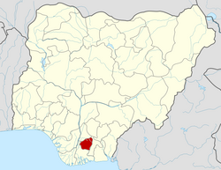
Oru West

Last updated

Oru West
LGA
Oru West L.G.A. Imo state.jpg
Oru West Headquarters Building
CountryNigeria
State Imo State
Time zone UTC+1 (WAT)
National language Igbo
Oru West

Oru West is a Local Government Area of Imo State, Nigeria. Its headquarters are in the town of Mgbidi.

It has an area of 93 km2 (36 sq mi) and a population of 159,300 [1] according to the 2016 Nigerian census.

The postal code of the area is 474. [2]

Related Research Articles

<span class="mw-page-title-main">Owerri</span> Capital city of Imo state, Nigeria

Owerri is the capital city of Imo State in Nigeria, set in the heart of Igboland. It is also the state's largest city, followed by Orlu, Okigwe and Ohaji/Egbema. Owerri consists of three Local Government Areas including Owerri Municipal, Owerri North and Owerri West, it has an estimated population of 1,401,873 as of 2016 and is approximately 100 square kilometres (40 sq mi) in area. Owerri is bordered by the Otamiri River to the east and the Nworie River to the south. The Owerri Slogan is Heartland. It is also called the Las Vegas of Africa, due to the night life of the city and the numerous hotels, casino and leisure parks all over the city.

<span class="mw-page-title-main">Orlu, Imo</span> LGA and city in Imo, Nigeria

Orlu is the second-largest city in South East, Imo State, Nigeria, with a population of 420,600. It has a long history as the headquarters for the Organisation of African Unity (OAU) and humanitarian relief agencies during the Nigeria-Biafra Civil War. The city houses the Nigerian headquarters of the British Cheshire Home. It is the second most developed city after Owerri in Imo state.

<span class="mw-page-title-main">Imo State</span> State of Nigeria

Imo State is a state in the South-East geopolitical zone of Nigeria, bordered to the north by Anambra State, Rivers State to the west and south, and Abia State to the east. It takes its name from the Imo River which flows along the state's eastern border. The state capital is Owerri and the State's slogan is the "Eastern Heartland."

Umuagwo is a town in the Ohaji/Egbema Local Government Area (LGA) of Imo State in Nigeria. The population is mostly Christian and Igbo-speaking. The town lies on the Otamiri River downstream from Ihiagwa and 26 km (16 mi) from Owerri on the Port Harcourt road. Eze Tony Oguzie, Chairman of the Council of Traditional Rulers in the Orlu senatorial zone, is monarch of Umuagwo.

<span class="mw-page-title-main">Ukwa East</span> LGA in Abia State, Nigeria

Ukwa East is a Local Government Area located in Abia State, Nigeria. Its headquarters is in the town of Akwete. Ukwa East is bordered by Akwa Ibom State and Rivers States.

<span class="mw-page-title-main">Aboh Mbaise</span> LGA and town in Imo State, Nigeria

Aboh Mbaise is a Local Government Area of Imo State, Nigeria. Its headquarters is in the town of Aboh.

<span class="mw-page-title-main">Ahiazu Mbaise</span> Town and Local Government Area in Imo State, Nigeria

Ahiazu Mbaise is a Local Government Area of Imo State, Nigeria. It is as a result of a merger between Ahiara and Ekwerazu. Its headquarters are in the town of Afo oru. There are fourteen (14) towns that make up Ahiazu Mbaise. They include; Mpam, Ihitte Afor, Opara-Nadim, Akabor, Ogwuama/Amuzi, Obodo-Ujichi, Otulu/Aguneze, Umu-OKrika, Obohia, Ekwereazu, Obodo-Ahiara, Lude/Nnara-Mbia, Ogbe, Oru - Ahiara. The 12 wards in Ahiazu Mbaise local government area are: Amuzi/Ihenworie, Mpam, Nnarambia, Obohia/Ekwereazu, Ogbe, Ogbor/Umueze, Okrika Nweke, Okrika Nwenkwo, Oparanadim, Oru-na-Lude, Otulu/Aguneze, Umunumo/Umuchieze.

<span class="mw-page-title-main">Ehime Mbano</span> Local Government Area in Imo State, Nigeria

Ehime Mbano is a local government area in Imo State, Nigeria.

<span class="mw-page-title-main">Ihitte/Uboma</span> Local Government Area in Imo State, Nigeria

Ihitte/Uboma is a local government area of Imo State, Nigeria. Its headquarters are in the town of Isinweke.

<span class="mw-page-title-main">Mbaitoli</span> LGA in Imo State, Nigeria

Mbaitoli is a Local Government Area of Imo State, Nigeria. Its headquarters are in the town of Nwaorieubi. It has an area of 204 km² and a population of 327,000. The postal code of the area is 461. Mbaitoli is divided into 9 autonomous communities with 12 INEC wards. The principal occupations of these communities are farming and handicrafts.

Ngor Okpala is a Local Government Area of Imo State, Nigeria. Its headquarters is in the town of Umuneke Ngor.

<span class="mw-page-title-main">Njaba</span> Local Government Area in Imo State, Nigeria

Njaba is a Local Government Area of Imo State, Nigeria. Its headquarters is located in the town of Nnenasa. It has an area of 84 km2 and a population of 143,485 at the 2006 census. The 2011 density projection is 2,004.5 inhabitants/km2. The postal code of the area is 474.

<span class="mw-page-title-main">Nkwerre</span> LGA and Town in Imo State, Nigeria

Nkwerre is one of the Local Government Areas in Imo State, South-East, Nigeria. It is situated in Nkwerre town where the name of the local government area was derived. Its population was placed at 80,270 from the 2006 population census with an area of 38.447 km. It is known for its thick vegetation which is supposed to prevent soil erosion however, it is erosion prone area.

<span class="mw-page-title-main">Nwangele</span> Local Government Abuja in Imo State, Nigeria

Nwangele is a Local Government Area of Imo State, Nigeria. The name was derived from the popular Nwangele river which marks the boundary between Amaigbo and Umuozu Isu. The river which is believed to have originated from Isiekenesi town passes through several villages in Amaigbo and empties into Oramiriukwa a tributary of Imo river. Its headquarter is in Amaigbo.

Ohaji/Egbema is an oil-rich Local Government Area of Imo State, Nigeria. It is headquartered in Mmahu-Egbema. Ohaji-Egbema Local Government Area as presently constituted was created by Gen. Ibrahim Babangida's administration in the August 27, 1991 presidential proclamation, created out of the former Ohaji/Egbema/Oguta L.G.A. Ohaji/Egbema comprises three political districts: Ohaji East, Egbema North, and Ohaji West. The Ohaji-Egbema local government has seventeen autonomous communities, namely Egbema, Umuagwo, Oloshi, Umunkwaku, Obile, Obitti, Mgbirichi/Alakuru, Opuoma, Assa, Awarra, Ikwerede, Umuokanne, Obiakpu, Ohaba, Obosima, Mmahu, and Obuomadike.

<span class="mw-page-title-main">Onuimo</span> Local Government Area in Imo State, Nigeria

Onuimo is a Local Government Area of Imo State, Nigeria. Its headquarters are in the town of Okwe. It comprises four towns namely: Okwe, Okwelle, Umuduru-Egbeaguru and Umuna. It is home to very prominent Nigerians such as The ever influential dynamic estate surveyor; Prof. James Gaius Ibe- USA trained and tenured professor of economics, finance and business administration, Dr Dennis Ndububa-a graduate of UNN with close to 40 years of professional practice as a medical doctor; Dr. Victor Ndububa; Dr. Christian Egemba; Dr. Kaunda Ibe-Consultant Neurosurgeon at Imo State University Teaching Hospital Orlu Imo State; Dr. Geraldine Echue-winner in Global Chemistry competition; Chief Adol N. Obi - the former bursar of Federal Polytechnic Nekede Owerri, and Engr Ekene Echefu - a lecturer in Mechatronics engineering department, federal polytechnic Nekede Owerri.Taiwo Damilola also served there. Also American author and writer Dreux Richard resides in Okwe to complete his writing when in Nigeria.

<span class="mw-page-title-main">Oru East</span> LGA in Imo State, Nigeria

Oru-East is a Local Government Area of Imo State, Nigeria. Its headquarters is at Omuma. The following are towns that make up Oru East: Akatta, Akuma, Amagu, Amiri, Awo-Omamma, and Omuma.

Owerri North is a Local Government Area of Imo State, Nigeria. Its headquarters are in the town of Orie Uratta. It has an area of 198 square km and a population of 175,395 at the 2006 census. The postal code of the area is 460. Owerri North is semi-urban government area. It encircles Owerri Municipal like a peninsula. Six major roads that lead out of the municipal cuts across Owerri North Communities. In the North, Orlu road leads to Amakaohia and Akwakuma communities. In the East, Okigwe road leads to Orji Community. In the West, MCC road off Wetheral to Obibi Uratta and Ihitaoha communities. In the South, Mbaise road leads to Egbu and Emekuku communities, while Aba road leads to Naze, Agbala and Ulakwo communities.

Owerri West is a Local Government Area of Imo State, Nigeria. Its headquarters are in the town of Umuguma. Owerri West Local Government is administered under the terms of the Constitution of the Federal Republic of Nigeria. Elections to the office of the Chairman of the local government are held through nominations by registered political parties as stipulated by the constitution of the Federal Republic of Nigeria, under the supervision of Imo State Electoral Commission. Owerri West was carved out of the former Owerri Local Government Area in 1996. A very large portion of the local government constitute the capital city of Imo State, Nigeria.

Amaigbo is a large town in Imo State, Nigeria. It is the headquarters of Nwangele Local Government Area. Amaigbo is regarded by many historians as the cradle of Igbo civilization.

References

  1. "Imo (State, Nigeria) - Population Statistics, Charts, Map and Location". www.citypopulation.de. Retrieved 2021-02-20.
  2. "Post Offices- with map of LGA". NIPOST. Archived from the original on 2009-10-07. Retrieved 2009-10-20.