
Papua is a province of Indonesia, comprising the northern coast of Western New Guinea together with island groups in Cenderawasih Bay to the west. It roughly follows the borders of Papuan customary region of Tabi Saireri. It is bordered by the sovereign state of Papua New Guinea to the east, the Pacific Ocean to the north, Cenderawasih Bay to the west, and the provinces of Central Papua and Highland Papua to the south. The province also shares maritime boundaries with Palau in the Pacific. Following the splitting off of twenty regencies to create the three new provinces of Central Papua, Highland Papua, and South Papua on 30 June 2022, the residual province is divided into eight regencies (kabupaten) and one city (kota), the latter being the provincial capital of Jayapura. The province has a large potential in natural resources, such as gold, nickel, petroleum, etc. Papua, along with five other Papuan provinces, has a higher degree of autonomy level compared to other Indonesian provinces.

Dutch New Guinea or Netherlands New Guinea was the western half of the island of New Guinea that was a part of the Dutch East Indies until 1949, later an overseas territory of the Kingdom of the Netherlands from 1949 to 1962. It contained what are now Indonesia's six easternmost provinces, Central Papua, Highland Papua, Papua, South Papua, Southwest Papua, and West Papua, which were administered as a single province prior to 2003 under the name Irian Jaya, and now comprise the Papua region of the country.

The Korowai, also called the Kolufo, are the people who live in southeastern Papua in the Indonesian provinces of South Papua and Highland Papua. Specifically their tribal area is split by the borders of Boven Digoel Regency, Mappi Regency, Asmat Regency, and Yahukimo Regency. They number about 3,000 people.

Western New Guinea, also known as Papua, Indonesian New Guinea, Indonesian Papua, is the western, Indonesian half of the island of New Guinea. Since the island is alternatively named as Papua, the region is also called West Papua.

Puncak Trikora, until 1963 Wilhelmina Peak, is a 4,730 or 4,750-metre-high (15,584 ft) mountain in the Highland Papua province of Indonesia on New Guinea. It lies in the eastern part of the Sudirman (Nassau) Range of the Maoke Mountains.

Sorong is the largest city and the capital of the Indonesian province of Southwest Papua. The city is located on the western tip of the island of New Guinea with its only land borders being with Sorong Regency. It is the gateway to Indonesia's Raja Ampat Islands, species rich coral reef islands in an area considered the heart of the world's coral reef biodiversity. It also is the logistics hub for Indonesia's thriving eastern oil and gas frontier. Sorong has experienced exponential growth since 2010, and further growth is anticipated as Sorong becomes linked by road to other frontier towns in Papua's Bird's Head Peninsula. The city had a population of 190,625 at the 2010 Census and 284,410 at the 2020 Census; the official estimate was 295,809. In mid 2022, 47.34% of the city population were Protestant, 44.82% were Muslim, and 7.55% Catholic, with minorities of Buddhists and Hindus. The city is served by Domine Eduard Osok Airport.

Frans Kaisiepo was a Papuan politician and Indonesian nationalist. He served as the fourth Governor of Papua Province. In 1993, Kaisiepo was posthumously declared a National Hero of Indonesia for his lifelong efforts to unite West Irian with Indonesia. As the representative of Papua province, he was involved in the Malino Conference, where the formation of the United States of Indonesia was discussed.

The South Bird's Head or South Doberai languages are three families of Papuan languages. They form part of the Trans–New Guinea languages in the classifications of Malcolm Ross (2005) and Timothy Usher (2020), though Pawley and Hammarström (2018) do not consider them to be part of Trans–New Guinea. However, according to Dryer (2022), based on a preliminary quantitative analysis of data from the ASJP database, South Bird's Head languages are likely to be a subgroup of Trans–New Guinea.

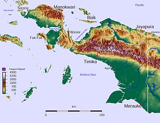
New Guinea is the world's second-largest island, with an area of 785,753 km2 (303,381 sq mi). Located in Melanesia in the southwestern Pacific Ocean, the island is separated from Australia by the 150-kilometre wide Torres Strait, though both landmasses lie on the same continental shelf. Numerous smaller islands are located to the west and east.

Sausapor is a small town and District in the Tambrauw Regency of Southwest Papua, Indonesia. The town is located on the northern coast of the Bird's Head Peninsula, also known as the Vogelkop Peninsula. According to the 2010 census, the kecamatan has a population of 2,633, and more recent figures reveal around 1000 people living in the main town of Sausapor. Sausapor is a major breeding ground for sea turtles and bird habitat.

Puncak Jaya, or Carstensz Pyramid on the island of New Guinea, with an elevation of 4,884 m (16,024 ft), is the highest mountain peak of an island on Earth. The mountain is located in the Sudirman Range of the highlands of Mimika Regency, Central Papua, Indonesia.
Korowai (Kolufaup) is a Trans-New-Guinean language spoken in South Papua, Indonesia. It is spoken by the Korowai people who live along the Becking River.
Duriankari, or Duriankere, is a possibly extinct Papuan language of Indonesian Papua. It is associated with the village of Duriankari at the southern tip of the island of Salawati, which is part of the Raja Ampat Archipelago and is adjacent to the Bird's Head Peninsula of the West Papuan mainland.

Silas Ayari Donrai Papare was a Papuan–Indonesian politician and guerilla leader who is a National Hero of Indonesia.
The West New Guinea dispute (1950–1962), also known as the West Irian dispute, was a diplomatic and political conflict between the Netherlands and Indonesia over the territory of Dutch New Guinea. While the Netherlands had ceded sovereignty over most of the Dutch East Indies to Indonesia on 27 December 1949 following an independence struggle, it retained control over its colony on the western half of New Guinea. The Indonesian government claimed this territory as well, on the basis that it had belonged to the Dutch East Indies and that the new Republic of Indonesia was the legitimate successor to the former Dutch colony.

Okaba is a coastal town in Merauke Regency, South Papua, Indonesia.
Bupul is an inland village in Merauke Regency, South Papua, Indonesia.
Kepi is a town in Mappi Regency, South Papua, Indonesia. Following the formation of Mappi Regency in 2002, the town became its administrative seat.
Alexandra Szalay is an Australian anthropologist and mammalogist, who specialises in the study of Papua New Guinea. The Gebe cuscus is named after her.

Central Papua, officially the Central Papua Province is an Indonesian province located in the central region of Western New Guinea. It was formally established on 11 November 2022 from the former eight western regencies of the province of Papua. It covers an area of 61,072.92 km2 and had an officially estimated population of 1,430,951 in mid 2022. It is bordered by the Indonesian provinces of West Papua to the west, province of Papua to the north, and by Highland Papua and South Papua to the east. The designated administrative capital is located in Nabire Regency.

