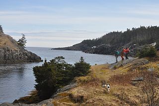
Chance Cove Provincial Park is a provincial park located approximately 20 km south of Renews-Cappahayden, Newfoundland and Labrador. Chance Cove was once the site of a small settlement of approximately 50 people in the mid-19th century, and is home to many shipwrecks of the Atlantic Ocean. Until the late 1980s, pieces of the forgotten homes were still visible.
Cape Ray is a local service district and designated place in the Canadian province of Newfoundland and Labrador. It is on the southwest coast of the island of Newfoundland.
Tompkins is a local service district and designated place in the Canadian province of Newfoundland and Labrador. It is in the Codroy Valley north of Channel-Port aux Basques.
Tors Cove is a local service district and designated place in the Canadian province of Newfoundland and Labrador. It is on the east coast of the Avalon Peninsula of the island of Newfoundland, approximately 40 kilometres south of the St. John's, the provincial capital, along Route 10. It was formerly named Toads Cove.
Upper Ferry is a local service district and designated place in the Canadian province of Newfoundland and Labrador. It is north of Port aux Basques.
Baine Harbour is a Canadian community in the province of Newfoundland and Labrador northeast of Marystown.
La Manche was a community on the east coast of the Avalon Peninsula of the island of Newfoundland between Cape Broyle and Tors Cove in a small inlet surrounded by steep hills. In French, la manche means "the sleeve". The area is named for the shape of the harbour, which is long and narrow with high sides. This harbour was probably first used by the French because of its seclusion which offered cover between raids on Ferryland and St. John's.
Articles related to the Canadian province of Newfoundland and Labrador include:
Butter Pot Provincial Park is a Provincial Park on the Avalon Peninsula of the island of Newfoundland, Canada. The park covers an area of approximately 28 km2 and is located on the Trans-Canada Highway about 35 km southwest of St. John's. The park is named for a prominent rounded hill inside the park boundary. Butter Pot incorporates both day-use and overnight camping facilities, and in winter months provides groomed cross-country ski trails.

Cape Anguille is a headland and the westernmost point in Newfoundland, reaching into the Gulf of Saint Lawrence. It is the southern edge of St. George's Bay. Its name is derived from the French word anguille, which means eel. Close to the cape is the community of Cape Anguille.
Heart's Desire is a town in the Canadian province of Newfoundland and Labrador. The town had a population of 184 in the Canada 2021 Census.
Lance Cove, Newfoundland and Labrador is a local service district and designated place in the Canadian province of Newfoundland and Labrador.
John Thomas Cheeseman was a businessman and politician in Newfoundland. He represented Burin from 1919 to 1923, Burgeo-LaPoile from 1956 to 1962 and Hermitage from 1962 to 1966.
South Branch is a settlement located on the west coast of the island of Newfoundland in the province of Newfoundland and Labrador, Canada. South Branch is one of fifteen communities within the greater Codroy Valley area and is located alongside the Trans-Canada Highway between Channel-Port aux Basques and St. George's Bay.
Searston is a local service district and designated place in the Canadian province of Newfoundland and Labrador.
St. Andrew's is a local service district and designated place in the Canadian province of Newfoundland and Labrador. It is in the Codroy Valley in the southwestern corner of the island of Newfoundland.
Great Codroy is a local service district and designated place in the Canadian province of Newfoundland and Labrador. In 2016, it had a population of 69.
Brown's Arm is a local service district and designated place in the Canadian province of Newfoundland and Labrador
Benoits Siding is a local service district and designated place in the Canadian province of Newfoundland and Labrador.
Frenchman's Cove Provincial Park, is a provincial park located on the west side of the Burin Peninsula in Newfoundland and Labrador, Canada.
This page is based on this
Wikipedia article Text is available under the
CC BY-SA 4.0 license; additional terms may apply.
Images, videos and audio are available under their respective licenses.

