
The northern gannet is a seabird, the largest species of the gannet family, Sulidae. It is native to the coasts of the Atlantic Ocean, breeding in Western Europe and Northeastern North America. It is the largest seabird in the northern Atlantic. The sexes are similar in appearance. The adult northern gannet has a mainly white streamlined body with a long neck, and long and slender wings. It is 87–100 cm long with a 170–180 cm (67–71 in) wingspan. The head and nape have a buff tinge that is more prominent in breeding season, and the wings are edged with dark brown-black feathers. The long, pointed bill is blue-grey, contrasting with black, bare skin around the mouth and eyes. Juveniles are mostly grey-brown, becoming increasingly white in the five years it takes them to reach maturity.

The Channel Islands National Marine Sanctuary is a sanctuary off the coast of Santa Barbara and Ventura counties in Southern California 350 miles south of San Francisco and 95 miles north of Los Angeles. It was designated in 1980 by the National Oceanic and Atmospheric Administration.
Ordination or gradient analysis, in multivariate analysis, is a method complementary to data clustering, and used mainly in exploratory data analysis. In contrast to cluster analysis, ordination orders quantities in a latent space. In the ordination space, quantities that are near each other share attributes, and dissimilar objects are farther from each other. Such relationships between the objects, on each of several axes or latent variables, are then characterized numerically and/or graphically in a biplot.
Monkman Provincial Park is a provincial park in British Columbia, southwest of Tumbler Ridge and northeast of Hansard. Like Monkman Pass, Monkman Lake, Monkman Creek and Monkman Falls, it was named after Alexander Monkman.
EPAS was a European non-commercial cooperation initiative which developing a series of data protocols to be applied in a point of sale (POS) environment. This included the protocols used by payment terminals and card payment systems. The project focused on three protocols; a terminal management protocol, a retailer application protocol and an acquirer protocol.

Witless Bay Ecological Reserve is an ecological preserve close to St. John's, Newfoundland and Labrador, Canada. The Witless Bay Ecological Reserve consists of four islands: Gull Island, Green Island, Great Island, and Pee Pee Island. Immense numbers of birds nest on these islands during the seabird breeding season, roughly from 1 April through 1 September.

Dichlorodiphenyldichloroethane (DDD) is an organochlorine insecticide that is slightly irritating to the skin. DDD is a metabolite of DDT. DDD is colorless and crystalline; it is closely related chemically and is similar in properties to DDT, but it is considered to be less toxic to animals than DDT. The molecular formula for DDD is (ClC6H4)2CHCHCl2 or C14H10Cl4, whereas the formula for DDT is (ClC6H4)2CHCCl3 or C14H9Cl5.

Cape St. Mary's Ecological Reserve is an ecological reserve located near Cape St. Mary's on the Cape Shore, on the southwestern Avalon Peninsula of Newfoundland.
Baccalieu Island Ecological Reserve is a wildlife reserve located on an island off the northeastern tip of Bay de Verde Peninsula of Newfoundland.
Heron Island is a small island of approximately 129 acres in the Saint Lawrence River and part of Sainte-Catherine, Quebec, Canada. The northern tip of the island is located in the Lachine rapids. It is one of "Saint-Laurent, Vision 2000" 37 protected sites. In 2002, Hydro Quebec donated the land to The Nature Conservancy of Canada (NCC) which manages the site as a wildlife reserve.
Private landowner assistance program (PLAP) is a class of government assistance program available throughout the U.S. for landowners interested in maintaining, developing, improving and protecting wildlife on their property. Each state provides various programs that assist landowners in agriculture, forestry and conserving wildlife habitat. This helps landowners in the practice of good land stewardship and provides multiple benefits to the environment. Some states offer technical assistance which includes:

Sidney Island is one of the southern Gulf Islands located between the southwest coast of British Columbia, Canada and Vancouver Island, BC, near James Island. Sidney Island has an elevation of 77 metres above mean sea level at its highest point. It is located just east of the town of Sidney which is on the east coast of the Saanich Peninsula. Sidney Island is a part of the Capital Regional District, while its land titles are legally described in the Cowichan Land District. In 1859 Captain Richards named the island for Frederick W. Sidney, who, like Richards served in the survey branch of the Royal Navy.
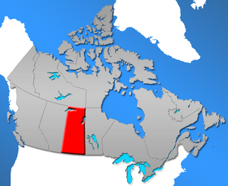
Historically, Saskatchewan's higher education system has been "significantly shaped" by demographics. In 1901, six years prior to the 1907 founding of a university in Saskatchewan, the urban population in Saskatchewan was 14,266 (16%) while the rural population was 77,013 (84%). One hundred years later, the proportions had changed significantly: urban population in 2001 was 629,036 (64%) while the rural population was 349,897 (36%). Over time the province's higher education system has changed significantly in response both to this demographic shift and to provincial politics.

Higher education in Prince Edward Island refers to education provided by higher education institutions in the Canadian province of Prince Edward Island. In Canada, education is the responsibility of the provinces and there is no Canadian federal ministry governing education. Prince Edward Island has two post-secondary institutions authorized to grant degrees: one university, the University of Prince Edward Island, and one college, Maritime Christian College. There are also two community colleges: Holland College, which operates centres across the province, and Collège de l'Île, which offers post secondary education in French. The governing body for higher education in Prince Edward Island is the Department of Innovation and Advanced Learning, headed by the Minister of Innovation and Advanced Learning, the Honourable Allen Roach.
The Lawrence Rocks are a group of two rocky islets, 6.8 ha and 1.5 ha in area, with an associated reef, 2.4 km south-east of Point Danger in western Victoria, Australia, and about 6 km south-east of the city of Portland. Geologically, the group is formed from the remnants of an extinct volcano, with the islets composed of basalt and tuff.

The environmental impact of iron ore mining in all its phases from excavation to beneficiation to transportation and beyond may have detrimental effects on air quality, water quality, biological species, and nearby communities. This is predominantly a result of large-scale iron ore tailings that are released into the environment which are harmful to both animals and humans.

Pee Pee Island is a small island located in the province of Newfoundland and Labrador in the far east of Canada. It is the smallest of the four islands in the Witless Bay Ecological Reserve, which it became a part of in 1983. It serves as a breeding place for Atlantic puffins.
Manitoba is home to a variety of ecosystems across the province that need to be considered in development and conservation plans. There are terrestrial ecosystems, which includes prairies, boreal forest, and tundra. Manitoba is also the home to a number of aquatic ecosystems, including wetlands, rivers, and lakes. There is also a wide variety of wildlife and plants that thrive in this particular region. However, human impact has become more apparent and the need to protect and conserve is becoming clear.
Baynes soil series is an imperfectly drained soil which occurs on eastern Vancouver Island and the adjacent Gulf Islands. Its parent material is eolian, fluvial or marine sand. The soil texture is usually loamy sand or sandy loam, but pure sand horizons may also be encountered. It is classified as Gleyed Dystric Brunisol or Gleyed Humo-Ferric Podzol.

Muriwai Regional Park is a regional park located in Muriwai on the west coast of the Auckland Region of New Zealand's North Island. It is situated in Rodney north-west of Auckland and is owned and operated by Auckland Council.

