The Gulf of Saint Lawrence is the outlet of the North American Great Lakes via the Saint Lawrence River into the Atlantic Ocean. The gulf is a semi-enclosed sea, covering an area of about 226,000 square kilometres (87,000 sq mi) and containing about 34,500 cubic kilometres (8,300 cu mi) of water, which results in an average depth of 152 metres (499 ft).

Kodachrome Basin is a state park of Utah, United States. It is situated 5,800 feet (1,767.8 m) above sea level, 12 miles (19 km) south of Utah Route 12, and 20 miles (32 km) southeast of Bryce Canyon National Park. It is accessible from the north from Cannonville by a paved road and from the south by Road 400, a dirt road from the Page, Arizona area to Cannonville, passable for most vehicles in dry conditions. A longer but paved route to Tropic from the south is also available via US-89 and SR-12.
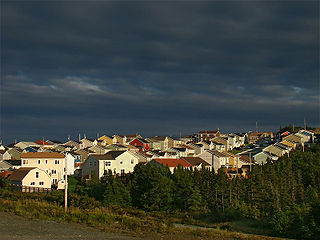
Paradise is a town on the Avalon Peninsula in the province of Newfoundland and Labrador, Canada.. The town is a part of the St. John's Metropolitan Area and borders the City of St. John's, the City of Mount Pearl, the Town of Portugal Cove-St. Philip's, and the town of Conception Bay South. According to the 2016 Canadian census the population of Paradise is 21,389, after recording a 21% increase in population over five years.

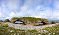
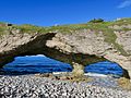
Percé Rock is a huge sheer rock formation in the Gulf of Saint Lawrence on the tip of the Gaspé Peninsula in Québec, Canada, off Percé Bay. Percé Rock appears from a distance like a ship under sail. It is one of the world's largest natural arches located in water and is considered a geologically and historically rich natural icon of Quebec. It is a major attraction in the Gaspésie region.

The exposed geology of the Capitol Reef area presents a record of mostly Mesozoic-aged sedimentation in an area of North America in and around Capitol Reef National Park, on the Colorado Plateau in southeastern Utah.

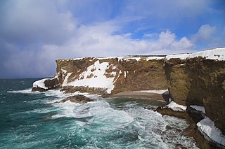
Chance Cove Provincial Park is a provincial park located approximately 20 km south of Renews-Cappahayden, Newfoundland and Labrador. Chance Cove was once the site of a small settlement of approximately 50 people in the mid-19th century, and is home to many shipwrecks of the Atlantic Ocean. Until the late 1980s, pieces of the forgotten homes were still visible.
The Port au Port Peninsula is a peninsula in the Canadian province of Newfoundland and Labrador. Roughly triangular in shape, it is located on the west coast of the island of Newfoundland.

The Flatirons are rock formations in the western United States, near Boulder, Colorado, consisting of flatirons. There are five large, numbered Flatirons ranging from north to south along the east slope of Green Mountain, and the term "The Flatirons" sometimes refers to these five alone. Numerous additional named Flatirons are on the southern part of Green Mountain, Bear Peak, and among the surrounding foothills.

The Hopewell Rocks, also called the Flowerpots Rocks or simply The Rocks, are rock formations caused by tidal erosion in The Hopewell Rocks Ocean Tidal Exploration Site in New Brunswick. They stand 40–70 feet tall.
Buckinghorse River Wayside Provincial Park is a provincial park in British Columbia, Canada located on the Alaska Highway, approximately 175 km northwest of the city of Fort St. John. It is located on the north side of the Buckinghorse River, to the northwest of the community of Pink Mountain. The park is 36 ha. in size and is near the community of Buckinghorse River.

Gabriola Sands Provincial Park is a provincial park in British Columbia, Canada. The park includes Taylor Bay, Pilot Bay, a fielded area, and the Malaspina Galleries, an unusual rock formation that resembles a breaking wave. Exploration of the galleries has been prohibited since 2004 due to safety concerns, though they are still accessible along the shoreline.
Milligan Hills Provincial Park is a provincial park in British Columbia, Canada, located 150 km (93 mi) northeast of Fort St. John near the border with Alberta.

Smuggler Cove Marine Provincial Park is a provincial park in British Columbia, Canada.
The Stikine River Provincial Park is a provincial park in British Columbia. The park covers a total area of approximately 217,000 hectares. The main feature of the Stikine River Provincial Park is a portion of the Stikine River known as "The Grand Canyon". This portion of the river is approximately eighty kilometers long and runs through a canyon that has been created from the river cutting through the rock that now forms the walls of the "canyon".

The Saskatchewan Transportation Company (STC) was a Crown corporation in the Canadian province of Saskatchewan responsible for operating intercity bus routes in the province from 1946 to 2017. Created in 1946 by an Order in Council giving the company a mandate to provide service between major urban centres and to as much of the rural population as possible, STC was a wholly owned subsidiary of the Crown Investments Corporation of Saskatchewan.

Burgeo is a Canadian town located on the south coast of the island of Newfoundland in the province of Newfoundland and Labrador.
Parson's Pond is a community in the province of Newfoundland and Labrador in Canada.
Pipers Hole River Provincial Park was a provincial park situated near Swift Current, Newfoundland and Labrador. The park was privatized in 1995 as a cost-cutting initiative by the provincial government. Between 1995 and 2008 the new owner failed and abandoned the property, and the park is no longer operating and is no longer a protected area under provincial jurisdiction.
The Doig Formation is a geologic formation of middle Triassic age in the Western Canadian Sedimentary Basin. It takes the name from Doig River, a tributary of the Beatton River, and was first described in the Texaco N.F.A. Buick Creek No. 7 well by J.H. Armitage in 1962..