Jackson Township, Callaway County, Missouri

Last updated

Jackson Township
Map highlighting Jackson Township, Callaway County, Missouri.svg
Coordinates: 39°01′01″N091°52′38″W / 39.01694°N 91.87722°W / 39.01694; -91.87722
Country United States
State Missouri
County Callaway
Area
  Total
64.7 sq mi (167.7 km2)
  Land64.49 sq mi (167.04 km2)
  Water0.25 sq mi (0.66 km2)  0.39%
Elevation
[1]
860 ft (262 m)
Population
 (2010)
  Total
2,150
  Density33.3/sq mi (12.9/km2)
FIPS code 29-35612 [2]
GNIS feature ID 0766379

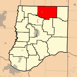
Jackson Township is one of eighteen townships in Callaway County, Missouri, USA. As of the 2010 census, its population was 2,150. [3]

Contents

History

Jackson Township was created December 25, 1875 [4] from the former northeastern sector of Liberty Township and the northwestern sector of Nine Mile Prairie Township—as one can see by comparing the 1867 and 1897 maps of Callaway County townships. This took the city of Auxvasse, out of Liberty Township and put it in the new Jackson Township. This is especially significant for historical and genealogical research.

Geography

Jackson Township covers an area of 64.75 square miles (167.7 km2) and contains one incorporated settlement, Auxvasse. It contains four cemeteries: Auxvasse, Grand Prairie, Harrison and Pleasant Grove.

The streams of Bynum Creek, Hunt Branch, Smith Branch and Yates Branch run through this township.

References

  1. "US Board on Geographic Names". United States Geological Survey. October 25, 2007. Retrieved January 31, 2008.
  2. "U.S. Census website". United States Census Bureau . Retrieved January 31, 2008.
  3. "Race, Hispanic or Latino, Age, and Housing Occupancy: 2010 Census Redistricting Data (Public Law 94-171) Summary File (QT-PL), Jackson township, Callaway County, Missouri". United States Census Bureau . Retrieved October 31, 2011.
  4. Missouri State Library; ' 'History of Callaway County, Missouri' '. St Louis: National Historical Company, 1884.