Kingdom City, Missouri

Last updated

Kingdom City, Missouri
Village of Kingdom City
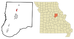
Callaway County Missouri Incorporated and Unincorporated areas Kingdom City Highlighted.svg
Location of Kingdom City, Missouri
Coordinates: 38°56′50″N91°56′19″W / 38.94722°N 91.93861°W / 38.94722; -91.93861 [1]
Country United States
State Missouri
County Callaway
Incorporated1973
Area
[2]
  Total1.88 sq mi (4.85 km2)
  Land1.85 sq mi (4.80 km2)
  Water0.02 sq mi (0.05 km2)
Elevation
[1]
801 ft (244 m)
Population
 (2020)
  Total134
  Density72.28/sq mi (27.91/km2)
Time zone UTC-6 (Central (CST))
  Summer (DST) UTC-5 (CDT)
ZIP code
65262
Area code 573
FIPS code 29-38792 [3]
GNIS feature ID2398350 [1]
U.S. Routes US 54.svg
Interstates I-70 (MO).svg
"Fire Fighter in Prayer" statue atop memorial wall, Fire Fighters Memorial of Missouri Fire Fighters Memorial of Missouri.jpg
"Fire Fighter in Prayer" statue atop memorial wall, Fire Fighters Memorial of Missouri

Kingdom City is a village in Callaway County, Missouri, United States. It is part of the Jefferson City Metropolitan Statistical Area. The population was 128 at the 2010 census. [4] The village lies north of the intersection of Interstate 70 and U.S. Route 54.

Contents

History

Kingdom City has its origins in the building of US Route 40 in 1925, at the same time US Route 54 was being planned with the intention of intersecting US 40 somewhere along the route. The city of Fulton had hoped for US 40 to go from Columbia through Fulton and intersect US 54 in their city, but the final decision had the highways intersect in what would become Kingdom City, which was then just a rural farm and forested area south of McCredie. McCredie residents fought so hard for the highway that they staged a parade through the heart of Fulton with banners that read "54-40 or Fight". When the road was being built and huge numbers of workers were brought in to do the work, McCredie became a boom town, with future Kingdom City receiving its first gas station and a two-story hotel, which (however) burned down in 1930. [5]

Since the area had no name at the time the intersection was referred to only as the "Y", with people in Fulton wanting to name it "North Fulton" and the people in McCredie naming it "South McCredie". The Kingdom Oil Company, owned by B.P. (Bernard Parker) Beamer, suggested Kingdom City, in reflection of the nickname for Callaway County. Through the 1920s and 30s numerous dance halls, restaurants, cafés, and hotels would come and go in Kingdom City. In 1965, Gasper's (which became a local landmark) opened for business. In 1970, the McCredie Post Office moved to Kingdom City and took the community's name. This was the same year Kingdom City incorporated as a village and included the former unincorporated community of McCredie. [5]

The Richland Christian Church was listed on the National Register of Historic Places in 2001. [6]

Geography

Kingdom City is located along U.S. Route 54 approximately one half mile north of I-70. McKinney Creek flows past the south edge of the community and Auxvasse Creek passes two miles to the north. The town of Auxvasse lies about five miles north along Route 54. [7]

According to the United States Census Bureau, the village has a total area of 1.82 square miles (4.71 km2), of which 1.80 square miles (4.66 km2) of it is land and 0.02 square miles (0.05 km2) is water. [8]

Demographics

Historical population
CensusPop.Note
1970 53
1980 146175.5%
1990 112−23.3%
2000 1218.0%
2010 1285.8%
2020 1344.7%
U.S. Decennial Census [9]

2010 census

As of the census [10] of 2010, there were 128 people, 49 households, and 34 families living in the village. The population density was 71.1 inhabitants per square mile (27.5/km2). There were 55 housing units at an average density of 30.6 per square mile (11.8/km2). The racial makeup of the village was 93.0% White, 6.3% African American, and 0.8% from two or more races. Hispanic or Latino of any race were 0.8% of the population.

There were 49 households, of which 24.5% had children under the age of 18 living with them, 53.1% were married couples living together, 8.2% had a female householder with no husband present, 8.2% had a male householder with no wife present, and 30.6% were non-families. 24.5% of all households were made up of individuals, and 10.2% had someone living alone who was 65 years of age or older. The average household size was 2.61 and the average family size was 3.09.

The median age in the village was 40 years. 22.7% of residents were under the age of 18; 8.6% were between the ages of 18 and 24; 23.4% were from 25 to 44; 25.8% were from 45 to 64; and 19.5% were 65 years of age or older. The gender makeup of the village was 50.8% male and 49.2% female.

2000 census

As of the census [3] of 2000, there were 121 people, 51 households, and 36 families living in the village. The population density was 89.3 inhabitants per square mile (34.5/km2). There were 54 housing units at an average density of 39.9 per square mile (15.4/km2). The racial makeup of the village was 90.91% White, 6.61% African American, 0.83% Native American, and 1.65% from two or more races.

There were 51 households, out of which 29.4% had children under the age of 18 living with them, 54.9% were married couples living together, 11.8% had a female householder with no husband present, and 29.4% were non-families. 21.6% of all households were made up of individuals, and 13.7% had someone living alone who was 65 years of age or older. The average household size was 2.37 and the average family size was 2.69.

In the village, the population was spread out, with 21.5% under the age of 18, 5.0% from 18 to 24, 23.1% from 25 to 44, 32.2% from 45 to 64, and 18.2% who were 65 years of age or older. The median age was 45 years. For every 100 females, there were 108.6 males. For every 100 females age 18 and over, there were 90.0 males.

The median income for a household in the village was $35,417, and the median income for a family was $34,583. Males had a median income of $28,125 versus $17,750 for females. The per capita income for the village was $16,978. None of the population and none of the families were below the poverty line.

Related Research Articles

<span class="mw-page-title-main">Callaway County, Missouri</span> County in Missouri, United States

Callaway County is a county located in the U.S. state of Missouri. As of the 2020 United States Census, the county's population was 44,283. Its county seat is Fulton. With a border formed by the Missouri River, the county was organized November 25, 1820, and named for Captain James Callaway, grandson of Daniel Boone. The county has been historically referred to as "The Kingdom of Callaway" after an incident in which some residents confronted Union troops during the U.S. Civil War.

<span class="mw-page-title-main">Banner, Illinois</span> Village in Illinois, United States

Banner is a village in Fulton County, Illinois, United States. The population was 189 at the 2010 census, up from 149 at the 2000 census.

<span class="mw-page-title-main">Butterfield, Missouri</span> City in Missouri, United States

Butterfield is a city in Butterfield Township, Barry County, Missouri, United States. The population was 378 at the 2020 census.

<span class="mw-page-title-main">Wheaton, Missouri</span> City in Missouri, United States

Wheaton is a city in Wheaton Township, Barry County, Missouri, United States. The population was 696 at the 2010 census.

<span class="mw-page-title-main">Auxvasse, Missouri</span> City in Missouri, United States

Auxvasse is a city in northern Callaway County, Missouri, United States. It is part of the Jefferson City, Missouri Metropolitan Statistical Area. The population was 983 at the 2010 census.

<span class="mw-page-title-main">Fulton, Missouri</span> City in Missouri, United States

Fulton is the largest city in and the county seat of Callaway County, Missouri, United States. Located about 22 miles (35 km) northeast of Jefferson City and the Missouri River and 20 miles (32 km) east of Columbia, the city is part of the Jefferson City, Missouri, Metropolitan Statistical Area. The population was 12,790 in the 2010 census. The city is home to two universities, Westminster College and William Woods University; the Missouri School for the Deaf; the Fulton State Hospital; and the Fulton Reception and Diagnostic Center state prison. Missouri's only nuclear power plant, the Callaway Plant is located 13 miles southeast of Fulton.

<span class="mw-page-title-main">Mokane, Missouri</span> City in Missouri, United States

Mokane is a small city in southern Callaway County, Missouri, United States. The population was 185 at the 2010 census. It is part of the Jefferson City Metropolitan Statistical Area.

<span class="mw-page-title-main">New Bloomfield, Missouri</span> City in Missouri, United States

New Bloomfield is a city in Cedar Township, Callaway County, Missouri, United States. The population was 669 at the 2010 census. It is part of the Jefferson City Metropolitan Statistical Area.

<span class="mw-page-title-main">Jerico Springs, Missouri</span> Village in Missouri, United States

Jerico Springs is a village in Cedar County, Missouri, United States. The population was 160 at the 2020 census.

<span class="mw-page-title-main">Eagleville, Missouri</span> Village in Missouri, United States

Eagleville is a village in northern Harrison County, Missouri, United States. The population was 275 at the 2020 census.

<span class="mw-page-title-main">Big Lake, Missouri</span> Village in Missouri, United States

Big Lake is a village in Holt County, Missouri, United States. The population was 65 at the 2020 census.

<span class="mw-page-title-main">Wilson City, Missouri</span> Village in Missouri, United States

Wilson City is a village in Mississippi County, Missouri, United States. The population was 77 at the 2020 census.

<span class="mw-page-title-main">Lilbourn, Missouri</span> City in Missouri, United States

Lilbourn is a city in New Madrid County, Missouri, United States. The population was 994 at the 2020 census.

<span class="mw-page-title-main">Wentworth, Missouri</span> Village in Missouri, United States

Wentworth is a village in northeastern Newton County, Missouri, United States. The population was 151 at the 2010 census. It is part of the Joplin, Missouri Metropolitan Statistical Area.

<span class="mw-page-title-main">Lakeshire, Missouri</span> City in Missouri, United States

Lakeshire is a city in St. Louis County, Missouri, United States. The population was 1,432 at the 2010 census.

<span class="mw-page-title-main">Deerfield, Missouri</span> Village in Missouri, United States

Deerfield is a village in Vernon County, Missouri, United States. The population was 40 at the 2020 census.

<span class="mw-page-title-main">Richards, Missouri</span> Village in Missouri, United States

Richards is a village in northwest Vernon County, Missouri, United States. The population was 96 at the 2010 census.

<span class="mw-page-title-main">Norwood, Missouri</span> City in Missouri, United States

Norwood is a city in Wright County, Missouri, United States. The population was 665 at the 2010 census.

<span class="mw-page-title-main">Raymondville, Missouri</span> Town in Missouri, United States

Raymondville is a town in Texas County, Missouri, United States. The population was 345 at the 2020 census.

<span class="mw-page-title-main">Ionia, Missouri</span> Village in Missouri, United States

Ionia is a village in northern Benton and southern Pettis counties in the U.S. state of Missouri. The population was 88 at the 2010 census.

References

  1. 1 2 3 U.S. Geological Survey Geographic Names Information System: Kingdom City, Missouri
  2. "ArcGIS REST Services Directory". United States Census Bureau. Retrieved August 28, 2022.
  3. 1 2 "U.S. Census website". United States Census Bureau . Retrieved January 31, 2008.
  4. "Race, Hispanic or Latino, Age, and Housing Occupancy: 2010 Census Redistricting Data (Public Law 94-171) Summary File (QT-PL), Kingdom City village, Missouri". United States Census Bureau . Retrieved October 28, 2011.
  5. 1 2 Berry, Evelyn (1990). "History of Kingdom City, Missouri". Daniel Boone Regional Library. Retrieved October 24, 2010.
  6. "National Register Information System". National Register of Historic Places . National Park Service. July 9, 2010.
  7. Kingdom City, MO 7.5 Minute Topographic Quadrangle, USGS, 1973 (1986 rev.)
  8. "US Gazetteer files 2010". United States Census Bureau. Archived from the original on July 2, 2012. Retrieved July 8, 2012.
  9. "Census of Population and Housing". Census.gov. Retrieved June 4, 2015.
  10. "U.S. Census website". United States Census Bureau . Retrieved July 8, 2012.

Sources