
Fort Wayne is a city in and the county seat of Allen County, Indiana, United States. Located in northeastern Indiana, the city is 18 miles (29 km) west of the Ohio border and 50 miles (80 km) south of the Michigan border. The city's population was 263,886 as of the 2020 census, making it the second-most populous city in Indiana after Indianapolis, and the 83rd-most populous city in the United States. It is the principal city of the Fort Wayne metropolitan area, consisting of Allen and Whitley counties which had an estimated population of 423,038 as of 2021. Fort Wayne is the cultural and economic center of northeastern Indiana.

Butler County is a county located in the southwestern part of the U.S. state of Ohio. As of the 2020 census, the population was 390,357. Its county seat and largest city is Hamilton. It is named for General Richard Butler, who died in 1791 during St. Clair's Defeat. Located along the Great Miami River, it is also home to Miami University, a public university founded in 1809. Butler County is part of the Cincinnati, OH-KY-IN Metropolitan Statistical Area. The majority of the county is in District 52 of the State House.

Wayne County is the most populous county in the U.S. state of Michigan. As of 2020, the United States Census placed its population at 1,793,561, making it the 19th-most populous county in the United States. The county seat is Detroit. The county was founded in 1796 and organized in 1815. Wayne County is included in the Detroit-Warren-Dearborn, MI Metropolitan Statistical Area. It is one of several U.S. counties named after Revolutionary War-era general Anthony Wayne.
Wayne County is a county located in east central Indiana, United States, on the border with Ohio. As of the 2020 United States Census, the population was 66,553. The county seat is Richmond. Wayne County comprises the Richmond, IN Micropolitan Statistical Area. Richmond hosts Earlham College, a small private liberal arts college.

Randolph County is a county located in the central section of U.S. state of Indiana, on its eastern border with Ohio. As of 2020, the population was 24,502. The county seat is Winchester.

Hamilton County is a county in the U.S. state of Indiana. The 2020 United States Census recorded a population of 347,467. The county seat is Noblesville.
Brown County is a county in Indiana which in 2020 had a population of 15,475. The county seat is Nashville.

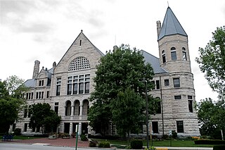
Allen County is a county in the U.S. state of Indiana. As of the 2020 Census, the population was 385,410, making it the third-most populous county in Indiana. The county seat and largest city is Fort Wayne, the second largest city in Indiana.
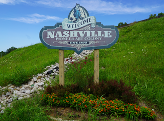
Nashville is a town in Washington Township, Brown County, Indiana, United States. The population was 803 at the 2010 census. The town is the county seat of Brown County and is the county's only incorporated town. The town is best known as the center of the Brown County Art Colony and as a tourist destination.

The Northwest Territory, also known as the Old Northwest and formally known as the Territory Northwest of the River Ohio, was formed from unorganized western territory of the United States after the American Revolution. Established in 1787 by the Congress of the Confederation through the Northwest Ordinance, it was the nation's first post-colonial organized incorporated territory.

Wayne Township is one of thirteen townships in Butler County, Ohio, United States. The township is located in the north-central part of the county, between Trenton and Oxford. It had a total population of 4,375 at the 2020 census.
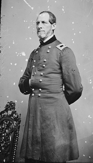
Solomon Meredith was an Indiana farmer, politician, and lawman who became a controversial Union Army general in the American Civil War. One of the commanders of the Iron Brigade of the Army of the Potomac, Meredith led the brigade in the Battle of Gettysburg. Although he never fully recovered from the wounds he received that day, he became a prize-winning farmer and cattleman at home and hosted veterans of his unit.

Northern Indiana is a geographic and cultural region that generally comprises the northern third of the U.S. state of Indiana and borders the states of Illinois to the west, Michigan to the north, and Ohio to the east. Spanning the state's northernmost 26 counties, its main population centers include Northwest Indiana, Michiana, and the Fort Wayne metropolitan area.

Indiana's 6th congressional district is a congressional district in the U.S. state of Indiana. The district takes in a portion of eastern and central Indiana as of the 2020 census, including Columbus and Richmond, some of Cincinnati's Indiana suburbs, most of Indianapolis' southern suburbs, and a sliver of Indianapolis itself.

The geography of Indiana comprises the physical features of the land and relative location of U.S. State of Indiana. Indiana is in the north-central United States and borders on Lake Michigan. Surrounding states are Michigan to the north and northeast, Illinois to the west, Kentucky to the south, and Ohio to the east. The entire southern boundary is the Ohio River.
The Mann Mound is a Native American mound in the southwestern part of the U.S. state of Ohio. Located near the unincorporated community of Jacksonburg in Butler County, it is tree-covered and sits on the edge of a field in Section 12 of Wayne Township. Its height is approximately 20 feet (6.1 m), and its circumference is approximately 540 feet (160 m).

Washington Township is one of twelve townships in Hendricks County, Indiana, United States. As of the 2010 census, its population was 44,764.

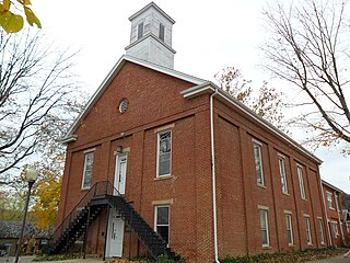
Harrison Township is one of fifteen townships in Wayne County, Indiana, United States. As of the 2010 census, its population was 392 and it contained 138 housing units.

Indiana is a state in the Midwestern region of the United States. It borders Lake Michigan to the northwest, Michigan to the north and northeast, Ohio to the east, the Ohio River and Kentucky to the south and southeast, and the Wabash River and Illinois to the west. Nicknamed "the Hoosier State", Indiana is the 38th-largest by area and the 17th-most populous of the 50 states. Its capital and largest city is Indianapolis. Indiana was admitted to the United States as the 19th state on December 11, 1816.
Abner M. Bradbury was an American politician. Bradbury represented Wayne County, Indiana in the Indiana House of Representatives and the Indiana Senate representing the Whig Party.


