
Fort Wayne is a city in and the county seat of Allen County, Indiana, United States. Located in northeastern Indiana, the city is 18 miles (29 km) west of the Ohio border and 50 miles (80 km) south of the Michigan border. The city's population was 263,886 as of the 2020 census, making it the second-most populous city in Indiana after Indianapolis, and the 83rd-most populous city in the United States. It is the principal city of the Fort Wayne metropolitan area, consisting of Allen and Whitley counties which had an estimated population of 423,038 as of 2021. Fort Wayne is the cultural and economic center of northeastern Indiana. In addition to the two core counties, the combined statistical area (CSA) includes Adams, DeKalb, Huntington, Noble, Steuben, and Wells counties, with an estimated population of 649,105 in 2021.
Wayne County is a county located in east central Indiana, United States, on the border with Ohio. As of the 2020 United States Census, the population was 66,553. The county seat is Richmond. Wayne County comprises the Richmond, IN Micropolitan Statistical Area. Richmond hosts Earlham College, a small private liberal arts college.

Jay County is a county in the U.S. state of Indiana. As of 2020, the population was 20,478. The county seat is Portland.

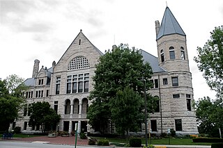
Allen County is a county in the U.S. state of Indiana. As of the 2020 Census, the population was 385,410, making it the third-most populous county in Indiana. The county seat and largest city is Fort Wayne, the second largest city in Indiana.

Pennville is a town in Penn Township, Jay County, Indiana, United States. The population was 701 at the 2010 census.

Pennville is a census-designated place (CDP) in York County, Pennsylvania, United States. The population was 1,947 at the 2010 census.
Pennville can refer to a place:

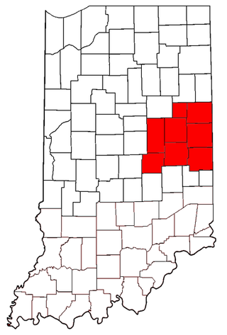
As of March 2020, the Fort Wayne–Huntington–Auburn Combined Statistical Area (CSA), or Fort Wayne Metropolitan Area, or Northeast Indiana is a federally designated metropolitan area consisting of eight counties in northeast Indiana, anchored by the city of Fort Wayne.

State Road 22 is an east–west discontinuous state road in the central part of the US state of Indiana. The western end of the western segment is in the town of Burlington, at SR 29. The highway passes through rural areas of Carroll and Howard counties, before ending in Kokomo. The eastern segment begins at an interchange with U.S. Route 31 and US 35, in Kokomo, and heads east passing through towns and cities like Greentown, Gas City and Upland, before ending at SR 26. The western segment of SR 22 is concurrent with US 35 from Kokomo to Interstate 69 (I-69). The entire road covers a distance of about 45 miles (72 km), passing through mostly rural areas.

State Road 23 is a highway in the north-central part of the U.S. state of Indiana. In practice it runs from the southwest to the northeast, though it is designated as a north–south route. It is an undivided surface road.

The Salamonie River is a tributary of the Wabash River, in eastern Indiana in the United States. The river is 84.4 miles (135.8 km) long. It is part of the watershed of the Mississippi River, via the Wabash and Ohio rivers. The USS Salamonie was named for the river.

Northern Indiana is a region of the U.S. State of Indiana, including 26 counties which border the states of Illinois, Michigan, and Ohio. Northern Indiana is also considered part of the Great Lakes Megalopolis. The area is generally classified into other sub-regions; Northwest Indiana is closely tied with Chicago economically, culturally, and politically and is part of the Chicago metropolitan area. The north central region centers on South Bend metropolitan area, with economic connections to southwest Michigan. Northeast Indiana is centered on the Fort Wayne metropolitan area.
East Central Indiana is a region in Indiana east of Indianapolis, Indiana, and borders the Ohio state line. The Indiana Gas Boom, which took place during the 1890s, changed much of the area from small agricultural communities to larger cities with economies that included manufacturing. Companies such as Ball Corporation and Overhead Door once had their headquarters in the region. Glass manufacturing was the first industry to be widespread in the area, because of the natural gas. As the glass industry faded, many of the skilled workers became employed at auto parts factories in cities such as Muncie and Anderson. With the decline of the American automobile industry, East Central Indiana became part of the Rust Belt. Many communities have been forced to reinvent themselves with a focus on services or a return to agriculture.

Indiana's 3rd congressional district is a congressional district in the U.S. state of Indiana. Based in Fort Wayne, the district takes in the northeastern part of the state. This district includes all of Adams, Allen, Blackford, DeKalb, Huntington, LaGrange, Noble, Steuben, Wells and Whitley counties, as well as northern Jay and northeast Kosciusko counties.

Penn Township is one of twelve townships in Jay County, Indiana, United States. As of the 2010 census, its population was 1,239 and it contained 569 housing units.

Jackson Township is one of fifteen townships in Wayne County, Indiana, United States. As of the 2010 census, its population was 4,660 and it contained 2,136 housing units.
The Rebecca Rankin Round Barn is a historic round barn in the far eastern part of the U.S. state of Indiana. Located along State Road 18 in far northern Jay County, the barn is one of many built throughout the state during the late nineteenth and early twentieth centuries. Its distinctive manner of construction has resulted in its designation as a historic site.
Pennville is an unincorporated community in Chattooga County, in the U.S. state of Georgia.
Pennville is an unincorporated community in northeast Sullivan County, in the U.S. state of Missouri.

Elections are held in Fort Wayne, Indiana to elect the city's mayor. Currently, such elections are regularly scheduled to be held every four years, in the year immediately preceding that of United States presidential elections.


