Jaypur, Bankura

Last updated

Jaypur
Village
India West Bengal adm location map.svg
Red pog.svg
Jaypur
Location in West Bengal, India
India location map.svg
Red pog.svg
Jaypur
Jaypur (India)
Coordinates: 23°02′51″N87°26′48″E / 23.0474°N 87.4467°E / 23.0474; 87.4467 Coordinates: 23°02′51″N87°26′48″E / 23.0474°N 87.4467°E / 23.0474; 87.4467
CountryFlag of India.svg  India
State West Bengal
District Bankura
Population
 (2011)
  Total3,136
Languages
  Official Bengali, English
Time zone UTC+5:30 (IST)
PIN
722138 (Jaypur)
Telephone/STD code03244
Lok Sabha constituency Bishnupur
Vidhan Sabha constituency Katulpur
Website bankura.gov.in

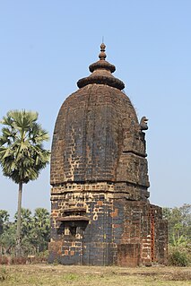
Jaypur (also spelled Joypur, Jaipur) is a village, with a police station, in Joypur CD Block in Bishnupur subdivision of Bankura district in the state of West Bengal, India.

Joypur, Bankura (community development block) Community development block in West Bengal, India

Joypur is a community development block that forms an administrative division in Bishnupur subdivision of Bankura district in the Indian state of West Bengal.

Bishnupur subdivision Subdivision in West Bengal, India

Bishnupur subdivision is a subdivision of the Bankura district in the state of West Bengal, India.

Bankura district District of West Bengal in India

Bankura district is an administrative unit in the Indian state of West Bengal. It is part of Medinipur division—one of the five administrative divisions of West Bengal. Bankura district is surrounded by Purba Bardhaman district and Paschim Bardhaman district in the north, Purulia district in the west, Jhargram district and Paschim Medinipur district in the south, and some part of Hooghly district in the east. Damodar River flows in the northern part of Bankura district and separates it with the major part of Burdwan district. The district head quarter is located in Bankura town.

Contents

Demographics

As per 2011 Census of India Jaypur had a total population of 3,136 of which 1,588 (51%) were males and 1,548 (49%) were females. Population below 6 years was 317. The total number of literates in Jaypur was 2,173 (77.08% of the population over 6 years). [1]

2011 Census of India 15th Indian Census

The 15th Indian Census was conducted in two phases, house listing and population enumeration. House listing phase began on 1 April 2010 and involved collection of information about all buildings. Information for National Population Register(NPR)was also collected in the first phase, which will be used to issue a 12-digit unique identification number to all registered Indian residents by Unique Identification Authority of India (UIDAI). The second population enumeration phase was conducted between 9 and 28 February 2011. Census has been conducted in India since 1872 and 2011 marks the first time biometric information was collected. According to the provisional reports released on 31 March 2011, the Indian population increased to 1.21 billion with a decadal growth of 17.70%. Adult literacy rate increased to 74.04% with a decadal growth of 9.21%. The motto of the census was 'Our Census, Our future'.

Police station

Joypur police station has jurisdiction over Joypur CD Block. The area covered is 262.74 km2 with a population of 139,693. [2] [3]

CD Block HQ

The headquarters of Joypur CD Block are located at Jaypur. [4]

Transport

State Highway 2 (West Bengal) running from Bankura to Malancha (in North 24 Parganas district) passes through Jaypur. [5]

State Highway 2 is a state highway in West Bengal, India.

Education

Joypur B.Ed. College is a private non-aided college. It is affiliated to the University of Burdwan and offers courses leading to the Bachelor of Education degree. Method subjects taught are: Bengali, English, Sanskrit, history and geography. [6] [7]

University of Burdwan public university in Bardhaman, West Bengal

The University of Burdwan is a premier Four Star public university in Purba Bardhaman, West Bengal, India. It was established by the West Bengal Government as a teaching and affiliating university on 15 June 1960 with six graduate departments and 30 undergraduate colleges spread over three districts that come under the jurisdiction of the university. The jurisdiction covers Birbhum district, Burdwan district except Asansol subdivision and Hooghly district except Srirampore subdivision. The main campus is of 398 acres (approximately).The University has Four Academic campus—1.Golapbag Campus 2.Uit campus for Engineering. 3.Rajbati Campus 4.Tara bag Campus It is awarded Four Star status by NAAC under UGC, Govt of India.

Healthcare

Jaypur Block Public Health Centre functions as the central facility in Joypur CD Block, with four Public Health Centres at Hijaldiha, Uttarbar, Jagannathpur and Hetia and 25 subcentres. [8]

Related Research Articles

Khatra Census Town in West Bengal, India

Khatra is a census town in Bankura district in the state of West Bengal, India. It is the headquarters of the Khatra subdivision.

Joypur, Purulia Community development block in West Bengal, India

Joypur is a community development block that forms an administrative division in Purulia Sadar West subdivision of Purulia district in the Indian state of West Bengal.

Chhatna (community development block) Community development block in West Bengal, India

Chhatna is a community development block that forms an administrative division in Bankura Sadar subdivision of Bankura district in the Indian state of West Bengal.

Saltora (community development block) Community development block in West Bengal, India

Saltora is a community development block that forms an administrative division in Bankura Sadar subdivision of Bankura district in the Indian state of West Bengal.

Indas (community development block) Community development block in West Bengal, India

Indas is a community development block that forms an administrative division in Bishnupur subdivision of Bankura district in the Indian state of West Bengal.

Patrasayer (community development block) Community development block in West Bengal, India

Patrasayer is a community development block that forms an administrative division in Bishnupur subdivision of Bankura district in the Indian state of West Bengal.

Sarenga, Bankura (community development block) Community development block in West Bengal, India

Sarenga is a community development block that forms an administrative division in Khatra subdivision of Bankura district in the Indian state of West Bengal.

Chhatna Village in West Bengal, India

Chhatna is a village, with a police station, in Chhatna CD Block in Bankura Sadar subdivision of Bankura district in the state of West Bengal, India.

Ranibandh (community development block) Community development block in West Bengal, India

Ranibandh is a community development block that forms an administrative division in Khatra subdivision of Bankura district in the Indian state of West Bengal.

Khatra (community development block) Community development block in West Bengal, India

Khatra is a community development block that forms an administrative division in Khatra subdivision of Bankura district in the Indian state of West Bengal.

Simlapal Census Town in West Bengal, India

Simlapal is a census town, with a police station, in Simlapal CD Block in Khatra subdivision of Bankura district in the state of West Bengal, India.

Taldangra Village in West Bengal, India

Taldangra is a village with a police station, in Taldangra CD Block in Khatra subdivision of Bankura district in the state of West Bengal, India.

Bankura I Community development block in West Bengal, India

Bankura I is a community development block that forms an administrative division in Bankura Sadar subdivision of Bankura district in the Indian state of West Bengal.

Bankura II Community development block in West Bengal, India

Bankura II is a community development block that forms an administrative division in Bankura Sadar subdivision of Bankura district in the Indian state of West Bengal.

Bishnupur, Bankura (community development block) Community development block in West Bengal, India

Bishnupur is a community development block that forms an administrative division in Bishnupur subdivision of Bankura district in the Indian state of West Bengal.

Sonamukhi (community development block) Community development block in West Bengal, India

Sonamukhi is a community development block that forms an administrative division in Bishnupur subdivision of Bankura district in the Indian state of West Bengal.

Jaypur, Purulia Census Town in West Bengal, India

Jaypur is a census town in Joypur CD Block in Purulia Sadar West subdivision of Purulia district in the state of West Bengal, India.

Patrasayer Village in West Bengal, India

Patrasayer is a village, with a police station, in Patrasayer CD Block in Bishnupur subdivision of Bankura district in the state of West Bengal, India.

References

  1. "2011 Census – Primary Census Abstract Data Tables". West Bengal – District-wise. Registrar General and Census Commissioner, India. Retrieved 14 October 2016.
  2. "District Statistical Handbook 2014 Bankura". Tables 2.1, 2.2. Department of Statistics and Programme Implementation, Government of West Bengal. Archived from the original on 29 July 2017. Retrieved 14 October 2016.
  3. "Joypur PS". Bankura District Police. Retrieved 14 October 2016.
  4. "District Census Handbook: Bankura" (PDF). Map of Bankura with CD Block HQs and Police Stations (on the fifth page). Directorate of Census Operations, West Bengal, 2011. Retrieved 20 November 2016.
  5. "List of State Highways in West Bengal". West Bengal Traffic Police. Retrieved 15 October 2016.
  6. "Joypur B.Ed. College". University of Burdwan. Retrieved 1 December 2016.
  7. "Joypur B.Ed. College". College Admission. Retrieved 1 December 2016.
  8. "Status of Health and FW Services in Bankura District". Chief Medical Officer of Health, Bankura. Retrieved 11 December 2016.