
U.S. Route 41, also U.S. Highway 41 (US 41), is a major north–south United States Numbered Highway that runs from Miami, Florida, to the Upper Peninsula of Michigan. Until 1949, the part in southern Florida, from Naples to Miami, was US 94. The highway's southern terminus is in the Brickell neighborhood of Downtown Miami at an intersection with Brickell Avenue (US 1), and its northern terminus is east of Copper Harbor, Michigan, at a modest cul-de-sac near Fort Wilkins Historic State Park at the tip of the Keweenaw Peninsula. US 41 closely parallels Interstate 75 (I-75) from Naples, Florida, all the way through Georgia to Chattanooga, Tennessee.

Michigan Avenue is a north-south street in Chicago which runs at 100 east on the Chicago grid. The northern end of the street is at Lake Shore Drive on the shore of Lake Michigan in the Gold Coast Historic District. The street's southern terminus is at Sibley Boulevard in the southern suburb of Harvey, though like many Chicago streets it exists in several disjointed segments.

U.S. Route 92 or U.S. Highway 92 is a 181-mile (291 km.) U.S. Route entirely in the U.S. state of Florida. The western terminus is at US 19 Alt. and SR 687 in downtown St. Petersburg. The eastern terminus is at SR A1A in Daytona Beach.

Route 15 is a state highway in the U.S. states of Rhode Island and Massachusetts. The highway runs 8.3 miles (13.4 km) from U.S. Route 44 in North Providence, Rhode Island east through Pawtucket to the Massachusetts state line, where the highway continues for 0.23 miles (0.37 km) to Route 152 in Seekonk.

State Route 143 is a primary state highway in the U.S. state of Virginia. The state highway runs 35.39 miles (56.95 km) from Camp Peary near Williamsburg east to U.S. Route 258 at Fort Monroe in Hampton. SR 143 is a major local thoroughfare on the Virginia Peninsula portion of the Hampton Roads metropolitan area. The state highway is named Merrimac Trail through the independent city of Williamsburg and adjacent portions of York County and James City County. SR 143 follows Jefferson Avenue through the city of Newport News from the Williamsburg area past Virginia Peninsula Regional Jail to near Downtown Newport News. The state highway, which mostly runs northwest–southeast, heads northeast from Newport News, serving as one highway connecting the downtown areas of Newport News and Hampton. SR 143 parallels both US 60 and Interstate 64 (I-64) extensively, and sometimes very closely, throughout its course. The state highway also runs concurrently with US 60 in Hampton and with US 17 in Newport News.

U.S. Route 20 in the U.S. state of Illinois is a major arterial highway that runs from the Iowa state line at East Dubuque at the northwestern tip of Illinois, to the Indiana state line at Chicago south of the Chicago Skyway, a distance of 233.93 miles (376.47 km). For its entire length, US 20 is designated as the General Ulysses S. Grant Highway, often abbreviated the U.S. Grant Memorial Highway. However, this name is only commonly used west of Elgin. US 20 bypasses the city of Elgin on a freeway known as the Elgin Bypass or Dr. Martin Luther King Jr. Memorial Highway. From Elgin to Melrose Park, US 20 follows Lake Street. It then follows Mannheim Road, and further south La Grange Road. US 20 also follows 95th Street as it turns east through Chicago's southwestern suburbs. It ultimately leaves Illinois on Indianapolis Boulevard.

U.S. Route 12 (US 12) in the U.S. state of Illinois is an arterial highway that runs northwest to southeast through the Chicago metropolitan area. It enters Illinois at the Wisconsin border north of Richmond, and exits into Hammond, Indiana from Chicago near the foot of the onramp to the Indiana Toll Road ; as it exits Illinois, the route is also concurrent with US 20 and US 41. Within Illinois, US 12 runs for a distance of 85.14 miles (137.02 km).
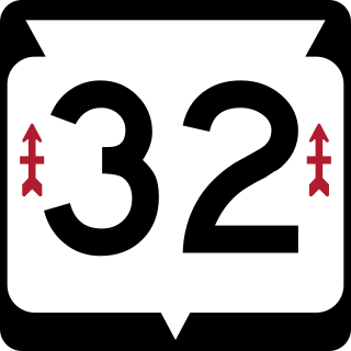
State Trunk Highway 32 is a state highway in the U.S. state of Wisconsin that runs north–south in the eastern part of the state. It runs from the Illinois border north to the Michigan border. It is named the 32nd Division Memorial Highway after the U.S. 32nd Infantry Division, and the highway shields have red arrows—the division's logo—on either side of the number 32. The route of WIS 32 and the Red Arrow marking is set in state statute by the Wisconsin Legislature.

U.S. Route 301 is a part of the U.S. Highway System that runs from Sarasota, Florida, to Biddles Corner, Delaware. In Virginia, the U.S. Highway runs 142.70 miles (229.65 km) from the North Carolina state line near Skippers north to the Maryland state line at the Potomac River near Dahlgren. US 301 forms the local complement to Interstate 95 (I-95) from Emporia to Petersburg. The U.S. Highway runs concurrently with US 1 between Petersburg and the state capital of Richmond, where the highways form one of the main north–south avenues. US 301 continues north concurrent with Virginia State Route 2 to Bowling Green, forming an eastern alternative to I-95 and US 1 north of Richmond. At Bowling Green, which is connected to I-95 by SR 207, US 301 becomes the primary highway connecting Richmond and the Northern Neck with Southern Maryland. US 301 was constructed in four main segments: as the original SR 24 and then US 17-1 south of Petersburg, as US 1 from Petersburg to Richmond, as SR 2 from Richmond to Bowling Green, and as part of SR 207 toward Dahlgren. US 301 replaced US 17–1 in the early 1930s and was extended from Petersburg north along its current course into Maryland when the Potomac River Bridge was completed in 1940.

U.S. Route 460 (US 460) in Virginia runs west-east through the southern part of the Commonwealth. The road has two separate pieces in Virginia, joined by a relatively short section in West Virginia. Most of US 460 is a four-lane divided highway and is a major artery in the southern third of the state. From Petersburg to Suffolk, US 460 is a four-lane non-divided highway. It is a popular alternative to Interstate 64 (I-64) when going from Richmond and other points in central Virginia to the Currituck Sound and Outer Banks of North Carolina, avoiding the congestion and tunnels of the more northerly I-64 corridor. The road passes through several small towns that built up at stops along the railroad line.
Stony Island Avenue is a major street on South Side of the city of Chicago, designated 1600 East in Chicago's street numbering system. It runs from 56th Street south to the Calumet River. Stony Island Avenue continues sporadically south of the Calumet in the southern suburbs, running alongside the Bishop Ford Freeway, sometimes as a frontage road. It terminates at County Line Road on the border of Will and Kankakee Counties.

North Avenue is a major east–west street in Chicago, Illinois, and its western suburbs. Starting at St. Charles's eastern border with West Chicago, its name changes from Main Street to North Avenue, just east of the Kane/DuPage county line. From there, it travels straight east, carrying Illinois Route 64 until LaSalle Drive in Chicago. Illinois Route 64 then continues north onto LaSalle Drive for a very short distance until ending at U.S. Route 41, while North Avenue continues east for less than one-half mile, changing its name to North Boulevard at Clark Street, and then continuing until its termination in a cul-de-sac at 200 East, just west of Lake Shore Drive. From Illinois Route 43 to its east end, North Avenue is within the city limits of Chicago.
U.S. Route 41 (US 41) in the U.S. state of Illinois runs north from the Indiana border beneath the Chicago Skyway on Indianapolis Boulevard to the Wisconsin border north of the northern terminus of the Tri-State Tollway with Interstate 94. It is the only north–south U.S. Route to travel through a significant portion of the city of Chicago, carrying Lake Shore Drive through the central portion of the city along the lakefront. US 41 in Illinois is 64.81 miles (104.30 km) in length.
95th Street is a major east–west highway on Chicago's South Side and in the southwest suburbs, designated as 9500 South in Chicago's address system. 95th Street is 11 miles (18 km) south of Madison Street.
Cicero Avenue, also known as Skokie Boulevard in Skokie and Wilmette, is a major north-south street in Chicago and its suburbs in Cook and Will Counties. It carries Illinois Route 50 from its south end to Skokie, and U.S. Route 41 from Skokie to its north end. It runs north from the Governors Highway in University Park, next to Governors State University, crossing major highways such as Interstate 294, Interstate 55, Interstate 290 and Interstate 94, to Interstate 94 in Wilmette. Cicero Avenue is located 6 miles west of State Street.
Several special routes of U.S. Route 20 exist. In order from west to east they are as follows.
Pershing Road is an east-west street on the south side of Chicago and in its immediate western suburbs in Cook County, Illinois. It is precisely four miles south of Madison Street, the division point between north and south street numbering, and marks the 3900 South point in the region's street numbering system. Its western segment, more commonly referred to as 39th Street, runs east from a U.S. Route 34 in Lyons to Illinois Route 50 in Cicero. Its eastern segment, officially known as Pershing Road, runs east from a cul-de-sac at 3600 West to Oakwood Boulevard, which continues east ending at U.S. Route 41. All of the eastern segment lies within the city of Chicago.
Garfield Boulevard is an east-west street on the south side of Chicago and its immediate western suburbs. Its western segment, entirely known as 55th Street, runs east from Maple Avenue in Downers Grove until it becomes Joliet Road in Countryside. Its eastern segment, known only as Garfield Boulevard from Western Avenue in Gage Park to Elsworth Drive in Washington Park, runs east from Archer Avenue and Narragansett Avenue to South Shore Drive, just west of U.S. Route 41. All of the eastern segment of 55th Street lies within the city limits of Chicago.
Torrence Avenue is a major north–south street in the South Side of Chicago, as well as its southern suburbs. It marks 2628 East in the Chicago address system, being located slightly more than 3+1⁄4 miles (5.2 km) east of State Street. The road runs north from Richton Road in Crete to Steger Road at the Will–Cook county line in Sauk Village. From there, its northern segment begins just west of here. Torrence Avenue continues north, intersecting Interstate 80 (I-80) and I-94 in Lansing. From here, the road goes north until ending just south of 95th Street. The road carries Illinois Route 83 (IL 83) from Glenwood Dyer Road in Lynwood to Sibley Boulevard in Calumet City, as well as carrying US 6 from the Kingery Expressway to 159th Street.
Dempster Street is a major east-west street in the northern suburbs of Chicago. It is assigned 8800 North in the Chicago address system, being located 11 miles (18 km) north of Madison Street.