Jose Dalman

Last updated
Jose Dalman
Ponot
Municipality of Jose Dalman
Flag of Jose Dalman, Zamboanga del Norte.png
Seal of Jose Dalman.png
Nickname: 
The Pink Town
Ph locator zamboanga del norte jose dalman.png
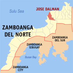
Map of Zamboanga del Norte with Jose Dalman highlighted
OpenStreetMap
Jose Dalman
Philippines location map (square).svg
Red pog.svg
Jose Dalman
Location within the Philippines
Coordinates: 8°26′34″N123°01′19″E / 8.4428°N 123.0219°E / 8.4428; 123.0219
Country Philippines
Region Zamboanga Peninsula
Province Zamboanga del Norte
District 2nd district
Founded 1979
Named after Jose Cabilin Dalman
Barangays 18 (see Barangays)
Government
[1]
  Type Sangguniang Bayan
   Mayor Allen T. Ferrater (Lakas)
   Vice Mayor Julieta J. Macapaz (Lakas)
   Representative Irene G. Labadlabad (Lakas)
   Municipal Council
Members
  • Richard L. Sabejon
  • Elmer D. Libre
  • Felimon L. Jakosalem, Jr.
  • Evangeline G. Campos
  • Val Angelo D. Regencia
  • Richard D. Dalogdog, Jr.
  • Rizalina M. Dalman
  • Benjamin V. Amahan
   Electorate 22,288 voters (2025)
Area
[2]
  Total
135.00 km2 (52.12 sq mi)
Elevation
78 m (256 ft)
Highest elevation
390 m (1,280 ft)
Lowest elevation
0 m (0 ft)
Population
 (2024 census) [3]
  Total
27,951
  Density210/km2 (540/sq mi)
   Households
6,187
Economy
   Income class 5th municipal income class
   Poverty incidence
57.66
% (2021) [4]
   Revenue 180.4 million (2022)
   Assets 238 million (2022)
   Expenditure 73.28 million (2022)
   Liabilities 13.36 million (2022)
Service provider
  ElectricityZamboanga del Norte Electric Cooperative (ZANECO)
Time zone UTC+8 (PST)
ZIP code
7111
PSGC
IDD : area code +63(0)65
Native languages Subanon
Cebuano
Chavacano
Tagalog
Website josedalman.zamboangadelnorte.com

Jose Dalman, officially the Municipality of Jose Dalman (Cebuano : Lungsod sa Jose Dalman; Subanen: Benwa Jose Dalman; Chavacano: Municipalidad de Jose Dalman; Tagalog : Bayan ng Jose Dalman), is a municipality in the province of Zamboanga del Norte, Philippines. According to the 2020 census, it has a population of 28,881 people. [5]

Contents

History

Jose Dalman, formerly known as Ponot, was originally part of the municipality of Manukan.

The municipality was established by virtue of Batas Pambansa (BP) Blg. 15 approved on January 3, 1979, upon separation of seven barangays in southwestern part of Manukan, with Barangay Ponot the seat of government. [6] A plebiscite was held on April 3. [7]

It was renamed by virtue of BP Blg. 381 enacted on April 8, 1983, [8] [9] through the effort of former Assemblyman Guardson Lood.

It is named after Jose C. Dalman, one of the former students of the national hero Jose Rizal during his exile in Dapitan.

Geography

Barangays

Jose Dalman is politically subdivided into 18 barangays. Each barangay consists of puroks while some have sitios.

  • Balatakan
  • Bitoon
  • Dinasan
  • Ilihan
  • Labakid
  • Lipay
  • Litalip
  • Lopero
  • Lumaping
  • Madalag
  • Manawan
  • Marupay
  • Poblacion (Ponot)
  • Sigamok
  • Siparok
  • Tabon
  • Tamarok
  • Tamil

Climate

Climate data for Jose Dalman, Zamboanga del Norte
MonthJanFebMarAprMayJunJulAugSepOctNovDecYear
Mean daily maximum °C (°F)29
(84)
29
(84)
30
(86)
31
(88)
30
(86)
30
(86)
29
(84)
30
(86)
30
(86)
29
(84)
29
(84)
29
(84)
30
(85)
Mean daily minimum °C (°F)23
(73)
23
(73)
23
(73)
24
(75)
25
(77)
25
(77)
24
(75)
24
(75)
24
(75)
24
(75)
24
(75)
24
(75)
24
(75)
Average precipitation mm (inches)104
(4.1)
76
(3.0)
92
(3.6)
97
(3.8)
199
(7.8)
238
(9.4)
195
(7.7)
193
(7.6)
178
(7.0)
212
(8.3)
171
(6.7)
110
(4.3)
1,865
(73.3)
Average rainy days14.712.515.817.527.628.529.027.526.927.923.518.2269.6
Source: Meteoblue [10]

Demographics

Population census of Jose Dalman
YearPop.±% p.a.
1980 15,308    
1990 17,952+1.61%
1995 21,745+3.66%
2000 23,322+1.51%
2007 26,017+1.52%
2010 27,033+1.40%
2015 27,388+0.25%
2020 28,881+1.12%
2024 27,951−0.78%
Source: Philippine Statistics Authority [11] [12] [13] [14] [15]

Economy

Poverty incidence of Jose Dalman

10
20
30
40
50
60
70
80
2000
71.05
2003
70.16
2006
63.40
2009
68.00
2012
62.75
2015
58.73
2018
56.48
2021
57.66

Source: Philippine Statistics Authority [16] [17] [18] [19] [20] [21] [22] [23]

Notable personalities

See also

References

  1. Municipality of Jose Dalman | (DILG)
  2. "2015 Census of Population, Report No. 3 – Population, Land Area, and Population Density" (PDF). Philippine Statistics Authority. Quezon City, Philippines. August 2016. ISSN   0117-1453. Archived (PDF) from the original on May 25, 2021. Retrieved July 16, 2021.
  3. "2024 Census of Population (POPCEN) Population Counts Declared Official by the President". Philippine Statistics Authority. 17 July 2025. Retrieved 18 July 2025.
  4. "PSA Releases the 2021 City and Municipal Level Poverty Estimates". Philippine Statistics Authority. 2 April 2024. Retrieved 28 April 2024.
  5. "2024 Census of Population (POPCEN) Population Counts Declared Official by the President". Philippine Statistics Authority. 17 July 2025. Retrieved 18 July 2025.
  6. "Batas Pambansa Blg. 15". The LawPhil Project. Arellano Law Foundation. January 3, 1979. Retrieved June 22, 2020.
  7. "Proclamation No. 1829, s. 1979". Official Gazette (Philippines) . Government of the Philippines. March 6, 1979. Retrieved March 22, 2023.
  8. Batas Pambansa Blg. 381, PhilippineLaw.info, retrieved 2012 Archived 2012-05-19 at the Wayback Machine
  9. "Batas Pambansa Blg. 381". Chan Robles Virtual Law Library. Retrieved June 22, 2020.
  10. "Jose Dalman: Average Temperatures and Rainfall". Meteoblue. Retrieved 30 April 2020.
  11. "2024 Census of Population (POPCEN) Population Counts Declared Official by the President". Philippine Statistics Authority. 17 July 2025. Retrieved 18 July 2025.
  12. Census of Population (2015). "Region IX (Zamboanga Peninsula)". Total Population by Province, City, Municipality and Barangay. Philippine Statistics Authority . Retrieved 20 June 2016.
  13. Census of Population and Housing (2010). "Region IX (Zamboanga Peninsula)" (PDF). Total Population by Province, City, Municipality and Barangay. National Statistics Office . Retrieved 29 June 2016.
  14. Censuses of Population (1903–2007). "Region IX (Zamboanga Peninsula)". Table 1. Population Enumerated in Various Censuses by Province/Highly Urbanized City: 1903 to 2007. National Statistics Office.
  15. "Province of". Municipality Population Data. Local Water Utilities Administration Research Division. Retrieved 17 December 2016.
  16. "Poverty incidence (PI):". Philippine Statistics Authority. Retrieved December 28, 2020.
  17. "Estimation of Local Poverty in the Philippines" (PDF). Philippine Statistics Authority. 29 November 2005.
  18. "2003 City and Municipal Level Poverty Estimates" (PDF). Philippine Statistics Authority. 23 March 2009.
  19. "City and Municipal Level Poverty Estimates; 2006 and 2009" (PDF). Philippine Statistics Authority. 3 August 2012.
  20. "2012 Municipal and City Level Poverty Estimates" (PDF). Philippine Statistics Authority. 31 May 2016.
  21. "Municipal and City Level Small Area Poverty Estimates; 2009, 2012 and 2015". Philippine Statistics Authority. 10 July 2019.
  22. "PSA Releases the 2018 Municipal and City Level Poverty Estimates". Philippine Statistics Authority. 15 December 2021. Retrieved 22 January 2022.
  23. "PSA Releases the 2021 City and Municipal Level Poverty Estimates". Philippine Statistics Authority. 2 April 2024. Retrieved 28 April 2024.