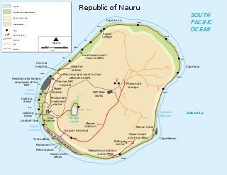
Nauru is a tiny phosphate rock island nation located in the South Pacific Ocean south of the Marshall Islands in Oceania. It is only 53 kilometres (33 mi) south of the Equator at coordinates 0°32′S166°55′E. Nauru is one of the three great phosphate rock islands in the Pacific Ocean—the others are Banaba in Kiribati and Makatea in French Polynesia.

The recorded history of Cape Verde begins with Portuguese discovery in 1456. Possible early references go back around 2000 years.

Necker Island, in Hawaiian Mokumanamana, is a small island in the Northwestern Hawaiian Islands. It is located at 23°34′30″N164°42′01″W in the Pacific Ocean, 430 miles northwest of Honolulu, Hawaii, 155 miles northwest of Nihoa, and 8 miles north of the Tropic of Cancer. It is part of the State of Hawaii in the United States. It contains important prehistoric archaeological sites of the Hawaiian culture and is part of the Hawaiian Islands National Wildlife Refuge within the Papahānaumokuākea Marine National Monument.

Maro Reef is a largely submerged coral atoll located in the Northwestern Hawaiian Islands. It was discovered in 1820 by Captain Joseph Allen of the ship Maro, after whose ship the reef was named. With a total area of 747 square miles (1,935 km2), it is the largest coral reef in the Northwestern Hawaiian Islands. It contains 37 species of stony coral. Unlike most atolls, the coral extends out from the center like spokes on a wheel. Located about 850 miles northwest of Honolulu, Hawaii, Maro Reef contains about 1 acre (4,000 m2) of dry land which itself can be submerged depending on the tides. Some scientists believe that it "may be on the verge of drowning" because the reefs are detached and are vulnerable to strong storm waves.

Iceberg B-15 was the largest recorded iceberg by area. It measured around 295 by 37 kilometres, with a surface area of 11,000 square kilometres. Calved from the Ross Ice Shelf of Antarctica in March 2000, Iceberg B-15 broke up into smaller icebergs, the largest of which was named Iceberg B-15-A. In 2003, B-15A drifted away from Ross Island into the Ross Sea and headed north, eventually breaking up into several smaller icebergs in October 2005. In 2018, a large piece of the original iceberg was steadily moving northward, located between the Falkland Islands and South Georgia Island. As of 2021, the U.S. National Ice Center (USNIC) still lists one extant piece of B-15 that meets the minimum threshold for tracking. This iceberg, B-15ab, measures 20 km × 7 km ; it is currently grounded off the coast of Antarctica in the western sector of the Amery region.
The Dollabarat Reef is a shoal situated 5 km south-southeast of the Formigas Islets on the Formigas Bank in the Azores archipelago.

Adelaide Island is a large, mainly ice-covered island, 139 kilometres (75 nmi) long and 37 kilometres (20 nmi) wide, lying at the north side of Marguerite Bay off the west coast of the Antarctic Peninsula. The Ginger Islands lie off the southern end. Mount Bodys is the easternmost mountain on Adelaide Island, rising to over 1,220 m. The island lies within the Argentine, British and Chilean Antarctic claims.

Bransfield Strait or Fleet Sea is a body of water about 100 kilometres (60 mi) wide extending for 300 miles (500 km) in a general northeast – southwest direction between the South Shetland Islands and the Antarctic Peninsula.

The Pacific Remote Islands Marine National Monument is a group of unorganized, mostly unincorporated United States Pacific Island territories managed by the United States Fish and Wildlife Service of the United States Department of the Interior and the National Oceanic and Atmospheric Administration (NOAA) of the United States Department of Commerce. These remote refuges are "the most widespread collection of marine- and terrestrial-life protected areas on the planet under a single country's jurisdiction". They protect many endemic species including corals, fish, shellfish, marine mammals, seabirds, water birds, land birds, insects, and vegetation not found elsewhere.

Stellwagen Bank National Marine Sanctuary is an 842-square-mile (638-square-nautical-mile) federally protected marine sanctuary located at the mouth of Massachusetts Bay, between Cape Cod and Cape Ann. It is known as an excellent whale watching site, and is home to many other species of marine life.

An ocean bank, sometimes referred to as a fishing bank or simply bank, is a part of the seabed that is shallow compared to its surrounding area, such as a shoal or the top of an underwater hill. Somewhat like continental slopes, ocean bank slopes can upwell as tidal and other flows intercept them, sometimes resulting in nutrient-rich currents. Because of this, some large banks, such as Dogger Bank and the Grand Banks of Newfoundland, are among the richest fishing grounds in the world.
Morro Negro is a hill located near the east coast of the island of Boa Vista, Cape Verde. Its elevation is 156 m. The nearest village is Cabeça dos Tarrafes, 5.5 km to the northwest.

The Princess Alice Bank is a submerged seamount located 50 nmi (93 km) southwest of the island of Pico and 45 nmi (83 km) southwest of the island of Faial in the Portuguese archipelago of the Azores. The western area of the bank has a minimum depth of 35 metres (115 ft), with clear waters allowing observation of the ocean floor from the surface. With an abundance of biodiversity, the bank is a fishing area, in addition to being an important diving spot of the Atlantic Ocean.

Nintoku Seamount or Nintoku Guyot is a seamount and guyot in the Hawaiian-Emperor seamount chain. It is a large, irregularly shaped volcano that last erupted 66 million years ago. Three lava flows have been sampled at Nintoku Seamount; the flows are almost all alkalic (subaerial) lava. It is 56.2 million years old.

The Tizard Bank, 10°15′N114°30′E is a partially sunken atoll and one of the significant maritime features of the north-western part of the Spratly Islands. It is claimed by the People's Republic of China, the Republic of China, and Vietnam, and various parts of it are occupied by these states.
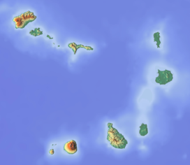
The Cape Verde Rise is an oceanic feature that includes the Cape Verde Islands and the areas north and east of the islands and west of the African Continental Shelf as well as Mauritania and Senegal.
Farol da Preguiça is a lighthouse located near the shore of Baía de São Jorge in Preguiça on the island of São Nicolau in northern Cape Verde. It is a masonry hut, coloured white. It sits at about 18 meters above sea level in the village, it is seven meters tall and its focal height is at 25 meters above sea level. Its focal range is 5 nautical miles. Its characteristic is Fl (2+1) R 15s.

The marine ecoregions of the South African exclusive economic zone are a set of geographically delineated regions of similar ecological characteristics on a fairly broad scale, covering the exclusive economic zone along the South African coast.
The Southeast Atlantic Seamounts Marine Protected Area is an offshore conservation region in the exclusive economic zone of South Africa

Cadamosto Seamount is a seamount in the Cape Verde islands, 25 kilometres (16 mi) southwest of Brava. It rises to a depth of 1,380 metres (4,530 ft) and partially overlaps with Brava. The seamount appears to be one of the recently active volcanic centres of the Cape Verde islands and has produced phonolite. The seamount has had intense volcanic eruptions in the late Pleistocene, and recent seismic activity indicates that volcanism is ongoing.