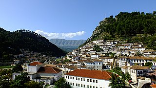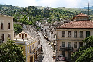
Epirus is a geographical and historical region in southeastern Europe, now shared between Greece and Albania. It lies between the Pindus Mountains and the Ionian Sea, stretching from the Bay of Vlorë and the Acroceraunian Mountains in the north to the Ambracian Gulf and the ruined Roman city of Nicopolis in the south. It is currently divided between the region of Epirus in northwestern Greece and the counties of Gjirokastër and Vlorë in southern Albania. The largest city in Epirus is Ioannina, seat of the Greek region of Epirus, with Gjirokastër the largest city in the Albanian part of Epirus.
Year 198 BC was a year of the pre-Julian Roman calendar. At the time it was known as the Year of the Consulship of Catus and Flamininus. The denomination 198 BC for this year has been used since the early medieval period, when the Anno Domini calendar era became the prevalent method in Europe for naming years.

Berat is the ninth most populous city of Albania and the seat of Berat County and Berat Municipality. By air, it is 71 kilometres north of Gjirokastër, 70 kilometres west of Korçë, 70 kilometres south of Tirana, and 33 kilometres east of Fier.

Përmet District was one of the 36 districts of Albania, which were dissolved in July 2000 and replaced by 12 newly created counties. It had a population of 25,837 in 2001, and an area of 929 km2 (359 sq mi). Its area has an Aromanian minority. It is in the south-east of the country, and its capital was the town of Përmet. Its territory is now part of Gjirokastër County: the municipalities of Përmet and Këlcyrë.

Tepelenë District was one of the 36 districts of Albania, which were dissolved in July 2000 and replaced by 12 newly created counties. It had a population of 32,465 in 2001, and an area of 817 km2 (315 sq mi). It was in the south of Albania, and its capital was the city of Tepelenë. Its territory is now part of Gjirokastër County: the municipalities of Tepelenë and Memaliaj.

Berat County, officially the County of Berat, is a county in the Southern Region of the Republic of Albania. It is the ninth largest by area and the ninth most populous of the twelve counties, with around 140,956 people within an area of 1,798 km2 (694 sq mi). The county borders the counties of Elbasan to the north, Korçë to the east, Gjirokastër to the south and Fier to the west. It is divided into five municipalities, Berat, Dimal, Kuçovë, Poliçan and Skrapar, with all of whom incorporate twenty-five administrative units.

Gjirokastër County is one of the 12 counties of Albania. The total population in 2023 was 60,013, in an area of 2884 km2. Its capital is the city Gjirokastër.

Përmet is a city and municipality in Gjirokastër County, southern Albania. The municipality of Përmet consists of the administrative units of Çarçovë, Frashër, Petran, Qendër Piskovë and Përmet. The total population is 10,614, in a total area of 602.47 km2. The population of the former municipality at the 2011 census was 5,945. It is flanked by the Vjosë river, which runs along the Trebeshinë-Dhëmbel-Nemërçkë mountain chain, between Trebeshinë and Dhëmbel mountains, and through the Këlcyrë Gorge.

The Regnum Albaniæ was established by Charles of Anjou in the Albanian territories he conquered from the Byzantine Empire in 1271, with the help of the local Albanian nobility. The Kingdom of Albania was declared in late February 1272. The kingdom extended from the region of Durazzo south along the coast to Butrint. A major attempt to advance further in direction of Constantinople failed at the Siege of Berat (1280–1281). A Byzantine counteroffensive soon ensued, which drove the Angevins out of the interior by 1281. The Sicilian Vespers further weakened the position of Charles, and the Kingdom was soon reduced by the Byzantines to a small area around Durazzo. The Angevins held out here, however, until 1368, when the city was captured by Karl Thopia. In 1392, Karl Thopia's son surrendered the city to the Republic of Venice.

The Vjosa or Aoös is a river in northwestern Greece and southwestern Albania. Its total length is about 272 kilometres (169 mi), of which the first 80 kilometres (50 mi) are in Greece, and the remaining 192 kilometres (119 mi) in Albania. Its drainage basin is 6,706 km2 (2,589 sq mi) and its average discharge is 195 m3/s (6,900 cu ft/s). The main tributaries are Voidomatis, Sarantaporos, Drino and Shushicë.
The Battle of the Aous was fought in 198 BC between the Roman Republic and the Kingdom of Macedon, in the area between modern Tepelenë and Këlcyrë in Albania. The Roman forces were led by Titus Quinctius Flamininus and the Macedonian ones were led by Philip V.
Defileul Dunării, also locally known as Clisura Dunării is a geographical region in Romania. It is located in southern Banat, along the northern bank of the river Danube. Clisura Dunării is situated between river Nera in the west, and Gura Văii or Cazanele Dunării in the east.

The Këlcyrë Gorge is a gorge in southern Albania created by the river Vjosë, near the town of Këlcyrë.

Veli Këlcyra (1862-1924), usually referred as Veli Bey Këlcyra, was an Albanian influential bey and one of the delegates during the Albanian Declaration of Independence.

John Zenevisi or Gjon Zenebishi was an Albanian magnate that held the estates in Epirus, such as Gjirokastër and Vagenetia.
Klisura, a South Slavic word of Greek origin (kleisoúra), for "pass", "gorge" or "canyon", may refer to:

Gjirokastër is a city in southern Albania and the seat of Gjirokastër County and Gjirokastër Municipality. It is located in a valley between the Gjerë mountains and the Drino, at 300 metres above sea level. Its old town is a UNESCO World Heritage Site. The city is overlooked by Gjirokastër Fortress, where the Gjirokastër National Folk Festival is held every five years. It is the birthplace of former Albanian communist leader Enver Hoxha, and author Ismail Kadare.

Andrea II Muzaka (1318-1372) was an Albanian nobleman of the Muzaka family and the ruler of the Principality of Muzaka in the 14th century. He inherited the principality from his father, Teodor I Muzaka, who died around 1331. Andrea II is known for having expanded the Principality of Muzaka to its greatest extent, from the southern Adriatic coastline of Albania in the west to Kastoria in the east by the time of his death in 1372.

Stoya Muzaka, also known as Stoja Muzaka, was an Albanian nobleman, the Lord of Kastoria, and a member of the influential Albanian Muzaka family, which played a significant role in ruling parts of Southern Albania and Epirus.


