
Miller County is a county located in the U.S. state of Missouri. As of the 2020 United States census, the population was 24,722. Its county seat is Tuscumbia. The county was organized February 6, 1837 and named for John Miller, former U.S. Representative and Governor of Missouri.
Etterville is an unincorporated community in northern Miller County, Missouri, United States. It is located six miles east of Eldon on U.S. Route 54.
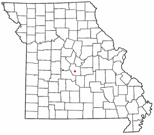
Ulman is an unincorporated community in southern Miller County, Missouri, United States. It is located on Missouri Route C, approximately three miles southwest of Missouri Route 17 and about five miles south of Tuscumbia and the Osage River.
Shaw is an unincorporated community in the Two-Mile Prairie of Boone County, Missouri, United States, northeast of Columbia. It is located at 38°58′25″N92°12′12″W.

Lamine Township is one of 14 civil townships in Cooper County, in the U.S. state of Missouri. Twenty-two of Missouri's 114 counties, including Cooper County, have civil township governments. The other 92 counties have townships which are geographical but not governmental (civil). According to the 1860 Census, the population of Lamine Township was 830 . As of the 2020 Census, Lamine Township's population was 257.
Marys Home is an unincorporated community in northern Miller County, in the U.S. state of Missouri. The community is on Missouri Route H, approximately two miles north of the Osage River. The town of Eugene in the southwest corner of Cole County is about four miles to the northwest, by Route H and Missouri Route 17.
Millersburg is an unincorporated community in Callaway County, in the U.S. state of Missouri. It is located near the Boone-Callaway county line on the Owl Creek tributary of Cedar Creek. The Little Dixie Lake and Little Dixie Wildlife Management Area lie on Owl Creek just north of the community. It is on Missouri Route J about four miles south of I-70.
Barnesville is an unincorporated community in Macon County, in the U.S. state of Missouri.
Atwell is an unincorporated community in the southeast corner of Miller County, in the U.S. state of Missouri. The community is on a low ridge between Atwell Creek to the east and Little Tavern Creek to the west. Access is by Missouri Route K from Missouri Route 17. Iberia is 5.5 miles to the northwest.
Brays is an unincorporated community in eastern Miller County, in the U.S. state of Missouri. The community is adjacent to Missouri Route 42 on the east side of the Tavern Creek floodplain, approximately three miles northeast of Iberia.
Faith is an unincorporated community in southern Miller County, in the U.S. state of Missouri. It is located approximately six miles southwest of Iberia near the headwaters of Barren Fork.
Hoecker is an unincorporated community in northeast Miller County, in the U.S. state of Missouri. The community is on a meander of the Osage River just south of the Miller-Cole county line. Henley is two miles to the west-northwest in Cole County and Meta is six miles to the east in Osage County.
Pleasant Mount or Mount Pleasant is an unincorporated community in Miller County, in the U.S. state of Missouri. The historic community was located along the current Missouri Route FF on a hilltop approximately one-half mile north of the railroad line. The current community of Mount Pleasant or Mt Pleasant is just south of U.S. Route 54, about three miles northeast of Eldon at 38°22′05″N92°31′25″W.
Rocky Mount is an unincorporated community in western Miller County, Missouri United States. The site is on Missouri Route Y approximately four miles southwest of Eldon. The Rocky Mount church is located at this location, however the post office was moved into neighboring Morgan County about two miles to the southwest in 1919. The Rocky Mount Lookout Tower and Rocky Mount Towersite State Wildlife Area lie approximately two miles to the east.
Spring Garden is an unincorporated community in northeastern Miller County, in the U.S. state of Missouri. The community lies just north of Missouri Route 54, approximately 8.5 miles northeast of Eldon.
Saint Anthony is an unincorporated community in eastern Miller County, in the U.S. state of Missouri. The community is located on Missouri Route A, west of Missouri Route 42 and above Tavern Creek. Brays is on Route 42 to the east and Iberia is 5.5 miles to the south-southwest.
Watkins is an unincorporated community in Miller County, in the U.S. state of Missouri. The community lies on a ridge between Barren and Brushy Forks on Missouri Route KK, approximately five miles northwest of Iberia.
Capps is an unincorporated community in northern Miller County, in the U.S. state of Missouri.
Clapper is an unincorporated community in Monroe County, in the U.S. state of Missouri.
Kennedy is an extinct town in Pemiscot County, in the U.S. state of Missouri. The GNIS classifies it as a populated place.

