Iberia, Missouri | |
---|---|
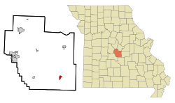
![]() Location in Miller County and the state of Missouri | |
Coordinates: 38°05′19″N92°17′46″W / 38.08861°N 92.29611°W [1] | |
Country | United States |
State | Missouri |
County | Miller |
Founded | 1860 |
Area | |
• Total | 0.88 sq mi (2.28 km2) |
• Land | 0.88 sq mi (2.28 km2) |
• Water | 0.00 sq mi (0.00 km2) |
Elevation | 938 ft (286 m) |
Population | |
• Total | 703 |
• Density | 797.96/sq mi (308.08/km2) |
Time zone | UTC-6 (Central (CST)) |
• Summer (DST) | UTC-5 (CDT) |
ZIP code | 65486 |
Area code | 573 |
FIPS code | 29-34228 [4] |
GNIS feature ID | 2394462 [1] |
Iberia is a city in southeast Miller County, Missouri, United States. The population was 703 as of the 2020 census. [3]
A post office called Iberia has been in operation since 1838. [5] The community derives its name from the Iberian Peninsula perhaps via New Iberia, Louisiana. [6]
Iberia Academy and Junior College was added to the National Register of Historic Places in 1980. [7]
Iberia is located in southeastern Miller County in the Ozarks of central Missouri. The city is at the intersection of routes 17 and 42. Route 17 leads northwest 15 miles (24 km) to Tuscumbia, the Miller county seat, and south 11 miles (18 km) to Crocker, while Route 42 leads west 18 miles (29 km) to Lake of the Ozarks State Park and northeast 22 miles (35 km) to Vienna.
According to the U.S. Census Bureau, Iberia has a total area of 0.88 square miles (2.28 km2), all land. [2] The city is drained to the north by Rabbithead Creek, a tributary of Tavern Creek, which in turn flows north to the Osage River.
Census | Pop. | Note | %± |
---|---|---|---|
1900 | 264 | — | |
1910 | 428 | 62.1% | |
1920 | 487 | 13.8% | |
1930 | 539 | 10.7% | |
1940 | 486 | −9.8% | |
1950 | 595 | 22.4% | |
1960 | 694 | 16.6% | |
1970 | 741 | 6.8% | |
1980 | 852 | 15.0% | |
1990 | 650 | −23.7% | |
2000 | 605 | −6.9% | |
2010 | 736 | 21.7% | |
2020 | 703 | −4.5% | |
U.S. Decennial Census [8] |
As of the census [9] of 2010, there were 736 people, 287 households, and 185 families living in the city. The population density was 836.4 inhabitants per square mile (322.9/km2). There were 347 housing units at an average density of 394.3 per square mile (152.2/km2). The racial makeup of the city was 95.8% White, 0.8% African American, 1.1% Native American, 0.7% from other races, and 1.6% from two or more races. Hispanic or Latino of any race were 3.0% of the population.
There were 287 households, of which 40.4% had children under the age of 18 living with them, 42.2% were married couples living together, 15.3% had a female householder with no husband present, 7.0% had a male householder with no wife present, and 35.5% were non-families. 31.0% of all households were made up of individuals, and 14.3% had someone living alone who was 65 years of age or older. The average household size was 2.56 and the average family size was 3.16.
The median age in the city was 31.4 years. 31.4% of residents were under the age of 18; 8.8% were between the ages of 18 and 24; 24.7% were from 25 to 44; 22.4% were from 45 to 64; and 12.8% were 65 years of age or older. The gender makeup of the city was 48.6% male and 51.4% female.
As of the census [4] of 2000, there were 605 people, 268 households, and 161 families living in the city. The population density was 672.8 inhabitants per square mile (259.8/km2). There were 327 housing units at an average density of 363.7 per square mile (140.4/km2). The racial makeup of the city was 97.85% White, 0.33% African American, 0.66% Native American, 0.17% Asian, 0.33% from other races, and 0.66% from two or more races. Hispanic or Latino of any race were 1.32% of the population.
There were 268 households, out of which 30.2% had children under the age of 18 living with them, 41.0% were married couples living together, 13.4% had a female householder with no husband present, and 39.9% were non-families. 35.8% of all households were made up of individuals, and 21.3% had someone living alone who was 65 years of age or older. The average household size was 2.26 and the average family size was 2.91.
In the city, the population was spread out, with 25.3% under the age of 18, 9.8% from 18 to 24, 25.5% from 25 to 44, 20.5% from 45 to 64, and 19.0% who were 65 years of age or older. The median age was 36 years. For every 100 females, there were 86.7 males. For every 100 females age 18 and over, there were 79.4 males.
The median income for a household in the city was $30,033, and the median income for a family was $28,750. Males had a median income of $25,500 versus $16,875 for females. The per capita income for the city was $12,918. About 13.6% of families and 17.8% of the population were below the poverty line, including 23.1% of those under age 18 and 18.1% of those age 65 or over.
The Iberia R-V School District operates an elementary school, a junior high school, and a high school. Junior high and elementary are linked in two buildings, and high school operates primarily in the annex.[ citation needed ]
Iberia has a public library, a branch of the Heartland Regional Library System. [10]
Belton is a city in northwestern Cass County, Missouri, United States. The population was 23,953 at the 2020 census.
Washington is a city on the south banks of the Missouri River, 50 miles west of St. Louis, Missouri, and the largest in Franklin County, Missouri, United States. The estimated population in July 2022 was 15,075, which is an increase of 3.97% since the 2020 U.S. census. It is notable for being the "corncob pipe capital of the world," with Missouri Meerschaum located on the riverfront.
Carl Junction is a city in Jasper County, Missouri, United States. The population was 8,143 at the 2020 census.
Brumley is a town in Miller County, Missouri, United States. The population was 91 at the 2010 census.
Crocker is a city in Pulaski County, Missouri, United States. The population was 1,110 at the 2010 census.
Nelson is a city in Saline County, Missouri, United States. The population was 152 at the 2020 census.
Bella Villa is a city in St. Louis County, Missouri, in the United States. As of the 2010 census, the city population was 729.
Country Club Hills is a city in St. Louis County, Missouri, United States. The population was 1,274 at the 2010 census.
Crystal Lake Park is a Missouri Class 4 city in St. Louis County, Missouri, United States. The population was 508 at the 2020 census.
Greendale is a city in St. Louis County, Missouri, United States. The population was 651 at the 2010 census.
Lakeshire is a city in St. Louis County, Missouri, United States. The population was 1,432 at the 2010 census.
Manchester is a city in St. Louis County, Missouri, United States. The population was 18,333 at the 2020 census.
Northwoods is a city in St. Louis County, Missouri, United States. The population was 4,227 at the 2010 census.
Pasadena Hills is a city in St. Louis County, Missouri, United States. The population was 930 at the 2010 census. The entire city is listed on the National Register of Historic Places.
Velda City is a city in St. Louis County, Missouri, United States. The population was 1,420 at the 2010 census.
Wildwood is a city in St. Louis County, Missouri, United States. It is located in the far western portion of the county. As of the 2020 census, the population was 35,417. Wildwood is the home of the Al Foster Trail, and numerous other trails, parks, and reserves such as Rockwoods Reservation and Babler State Park.
Winchester is a city in St. Louis County, Missouri, United States. The population was 1,447 at the 2020 census.
Moscow Mills is a city in Lincoln County, Missouri, United States. The population was 2,509 at the 2010 census.
Clarkson Valley is a city in St. Louis County, Missouri, United States. The population was 2,609 at the 2020 census.
Moline Acres is a city in St. Louis County, Missouri, United States. The population was 2,442 at the 2010 census.