Brumley, Missouri

Last updated

Brumley, Missouri
Miller County Missouri Incorporated and Unincorporated areas Brumley Highlighted.svg
Location in Miller County and the state of Missouri
Coordinates: 38°05′17″N92°29′04″W / 38.08806°N 92.48444°W / 38.08806; -92.48444 [1]
Country United States
State Missouri
County Miller
Area
[2]
  Total0.55 sq mi (1.43 km2)
  Land0.55 sq mi (1.43 km2)
  Water0.00 sq mi (0.00 km2)
Elevation
[1]
820 ft (250 m)
Population
 (2020) [3]
  Total69
  Density125.23/sq mi (48.35/km2)
Time zone UTC-6 (Central (CST))
  Summer (DST) UTC-5 (CDT)
ZIP code
65017
Area code 573
FIPS code 29-08974 [4]
GNIS feature ID2396614 [1]

Brumley is a town in Miller County, Missouri, United States. [1] The population was 69 at the 2020 census, [3] down from 91 in 2010.

Contents

History

There is uncertainty when Brumley was first laid out. Years given are 1858, [5] 1869, [6] and 1877. [5] The source of the name "Brumley" is also disputed. [5] A post office called Brumley has been in operation since 1863. [7]

Geography

Brumley is in southwestern Miller County, located on Missouri Route 42, east of Lake of the Ozarks State Park and west of Iberia. [8]

According to the U.S. Census Bureau, the town has a total area of 0.55 square miles (1.42 km2), all land. [2]

Demographics

Historical population
CensusPop.Note
1930 121
1940 100−17.4%
1950 78−22.0%
1960 74−5.1%
1970 8717.6%
1980 10925.3%
1990 81−25.7%
2000 10225.9%
2010 91−10.8%
2020 69−24.2%
U.S. Decennial Census [9]

2010 census

At the 2010 census, [10] there were 91 people, 40 households and 24 families living in the village. The population density was 165.5 inhabitants per square mile (63.9/km2). There were 48 housing units at an average density of 87.3 per square mile (33.7/km2). The racial makeup of the village was 78.0% White, 6.6% African American, 4.4% Native American, and 11.0% from two or more races. Hispanic or Latino of any race were 5.5% of the population.

There were 40 households, of which 32.5% had children under the age of 18 living with them, 40.0% were married couples living together, 15.0% had a female householder with no husband present, 5.0% had a male householder with no wife present, and 40.0% were non-families. 37.5% of all households were made up of individuals, and 25% had someone living alone who was 65 years of age or older. The average household size was 2.28 and the average family size was 3.00.

The median age in the village was 40.5 years. 27.5% of residents were under the age of 18; 4.4% were between the ages of 18 and 24; 24.2% were from 25 to 44; 25.3% were from 45 to 64; and 18.7% were 65 years of age or older. The gender makeup of the village was 54.9% male and 45.1% female.

2000 census

At the 2000 census, [4] there were 102 people, 41 households and 27 families living in the town. The population density was 211.3 inhabitants per square mile (81.6/km2). There were 49 housing units at an average density of 101.5 per square mile (39.2/km2). The racial makeup of the town was 86.27% White, 7.84% Native American, and 5.88% from two or more races. Hispanic or Latino of any race were 3.92% of the population.

There were 41 households, of which 31.7% had children under the age of 18 living with them, 48.8% were married couples living together, 9.8% had a female householder with no husband present, and 34.1% were non-families. 31.7% of all households were made up of individuals, and 9.8% had someone living alone who was 65 years of age or older. The average household size was 2.49 and the average family size was 3.07.

28.4% of the population were under the age of 18, 5.9% from 18 to 24, 26.5% from 25 to 44, 23.5% from 45 to 64, and 15.7% who were 65 years of age or older. The median age was 36 years. For every 100 females, there were 126.7 males. For every 100 females age 18 and over, there were 102.8 males.

The median household income was $22,500 and the median family income was $25,208. Males had a median income of $23,750 compared with $16,875 for females. The per capita income for the town was $10,468. There were 4.0% of families and 15.8% of the population living below the poverty line, including 16.0% of under-18s and 9.5% of those over 64.

Related Research Articles

<span class="mw-page-title-main">Benton, Maine</span> Town in the state of Maine, United States

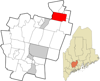
Benton is a town in Kennebec County, Maine, United States. It was formed in 1842, as a subdivision of the town of Clinton. The population was 2,715 at the 2020 census. The town was named for Missouri Senator Thomas Hart Benton.

<span class="mw-page-title-main">Lewis and Clark Village, Missouri</span> Village in Missouri, United States

Lewis and Clark Village is a village in Buchanan County, Missouri, United States. The population was 96 at the 2020 census. It is part of the St. Joseph, MO–KS Metropolitan Statistical Area.

<span class="mw-page-title-main">Rushville, Missouri</span> Village in Missouri, United States

Rushville is a village in western Buchanan County, Missouri, United States. The population was 225 at the 2020 census. It is part of the St. Joseph, MO–KS Metropolitan Statistical Area.

<span class="mw-page-title-main">Pattonsburg, Missouri</span> City in Missouri, United States

Pattonsburg is a city in northwest Daviess County, Missouri, United States. The population was 314 at the 2020 census.

<span class="mw-page-title-main">Brooklyn Heights, Missouri</span> Village in Missouri, United States

Brooklyn Heights is a village in Jasper County, Missouri, United States. The population was 101 at the 2020 census. It is part of the Joplin, Missouri Metropolitan Statistical Area.

<span class="mw-page-title-main">Linneus, Missouri</span> City in Missouri, United States

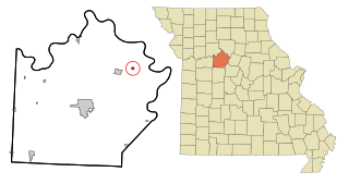
Linneus is a small city in Linn County, Missouri, United States. The population was 281 at the 2020 census. It is the county seat of Linn County.

<span class="mw-page-title-main">Ludlow, Missouri</span> Village in Missouri, United States

Ludlow is a village in southwest Livingston County, Missouri, United States. The population was 111 at the 2020 census. The median income in Ludlow is $30,833 and the median home value is $33,500.

<span class="mw-page-title-main">Tuscumbia, Missouri</span> Town in Missouri, United States

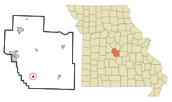
Tuscumbia is a village in and the county seat of Miller County, Missouri, United States. The population was 188 at the 2020 census.

<span class="mw-page-title-main">Grand Falls Plaza, Missouri</span> Village in Missouri, United States

Grand Falls Plaza is a village in Newton County, Missouri, United States. The population was 114 at the 2010 census, at which time it was a town. It is part of the Joplin, Missouri Metropolitan Statistical Area.

<span class="mw-page-title-main">Conception Junction, Missouri</span> City in Missouri, United States

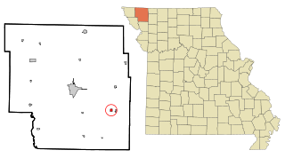
Conception Junction is a city in Nodaway County, Missouri, United States, near the Platte River. The population was 177 at the 2020 census.

<span class="mw-page-title-main">Pickering, Missouri</span> Village in Missouri, United States

Pickering is a city in Nodaway County, Missouri, United States. The population was 160 at the 2010 census.

<span class="mw-page-title-main">Ravenwood, Missouri</span> City in Missouri, United States

Ravenwood is a city in eastern Nodaway County, Missouri, United States, near the Platte River. The population was 439 at the 2020 census.

<span class="mw-page-title-main">Green Ridge, Missouri</span> City in Missouri, United States

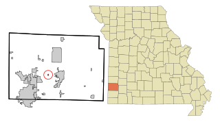
Green Ridge is a city located along Route 127 in Pettis County, Missouri, United States. The population was 476 at the 2010 census.

<span class="mw-page-title-main">Gilliam, Missouri</span> City in Missouri, United States

Gilliam is a city in Saline County, Missouri, United States. The population was 197 at the 2010 census.

<span class="mw-page-title-main">Grantwood Village, Missouri</span> Town in Missouri, United States

Grantwood Village is a town in St. Louis County, Missouri, United States. The population was 863 at the 2010 census.

<span class="mw-page-title-main">Norwood Court, Missouri</span> Village in Missouri, United States

Norwood Court is a village in St. Louis County, Missouri, United States. The population was 959 at the 2010 census.

<span class="mw-page-title-main">Moundville, Missouri</span> Village in Missouri, United States

Moundville is a village in southwest Vernon County, Missouri, United States. The population was 124 at the 2010 census.

<span class="mw-page-title-main">Richards, Missouri</span> Village in Missouri, United States

Richards is a village in northwest Vernon County, Missouri, United States. The population was 96 at the 2010 census.

<span class="mw-page-title-main">Ionia, Missouri</span> Village in Missouri, United States

Ionia is a village in northern Benton and southern Pettis counties in the U.S. state of Missouri. The population was 88 at the 2010 census.

<span class="mw-page-title-main">Argyle, Missouri</span> Town in Missouri, United States

Argyle is a town in Osage and Maries counties in the U.S. state of Missouri. The population was 144 at the 2020 census.

References

  1. 1 2 3 4 U.S. Geological Survey Geographic Names Information System: Brumley, Missouri
  2. 1 2 "ArcGIS REST Services Directory". United States Census Bureau. Retrieved August 28, 2022.
  3. 1 2 "P1. Race – Brumley town, Missouri: 2020 DEC Redistricting Data (PL 94-171)". U.S. Census Bureau. Retrieved April 17, 2024.
  4. 1 2 "U.S. Census website". United States Census Bureau . Retrieved January 31, 2008.
  5. 1 2 3 "Miller County Place Names, 1928–1945". The State Historical Society of Missouri. Archived from the original on June 24, 2016. Retrieved November 6, 2016.
  6. Eaton, David Wolfe (1916). How Missouri Counties, Towns and Streams Were Named. The State Historical Society of Missouri. pp.  194.
  7. "Post Offices". Jim Forte Postal History. Retrieved November 6, 2016.
  8. Missouri Atlas & Gazetteer, DeLorme, 1998, First edition, p. 45, ISBN   0-89933-224-2
  9. "Census of Population and Housing". Census.gov. Retrieved June 4, 2015.
  10. "U.S. Census website". United States Census Bureau . Retrieved July 8, 2012.