Olean, Missouri | |
---|---|
Coordinates: 38°24′37″N92°31′48″W / 38.41028°N 92.53000°W | |
Country | United States |
State | Missouri |
County | Miller |
Area | |
• Total | 0.17 sq mi (0.45 km2) |
• Land | 0.17 sq mi (0.45 km2) |
• Water | 0.00 sq mi (0.00 km2) |
Elevation | 781 ft (238 m) |
Population | |
• Total | 114 |
• Density | 658.96/sq mi (254.58/km2) |
Time zone | UTC-6 (Central (CST)) |
• Summer (DST) | UTC-5 (CDT) |
ZIP code | 65064 |
Area code | 573 |
FIPS code | 29-54560 [4] |
GNIS feature ID | 2396832 [2] |
Olean is a town in northern Miller County, Missouri, United States. The population was 114 at the 2020 census. [3]
The community was laid in 1881-1882 by the Jefferson City, Lebanon and Southwestern Railway which became the Missouri Pacific Railroad. It was originally called "Proctor", after James G. Proctor, who was an early settler. The name was rejected because there was another Procter in Missouri. It was then changed to "Cove" because of its semicircular shape. That name was also rejected because of another similar name in the state. "Chester" was suggested but again was rejected because there was another Chester on the rail line. Ultimately, the railroad company imposed the name "Olean", after Olean, New York, apparently on a lark, as no documentation survives explaining any reasoning for choosing a city with no connections to the town in Missouri, which in turn had no connection to oil. [5] [6] Attribution to Dr. W.S. Allee appear not to be true, as Allee never lived in or visited New York State. [7]
At the turn of the 20th century, Olean contained a gristmill and a canning factory. [8]
The railroad left the community in 1962; its station is now listed on the National Register of Historic Places. [9]
Since 1993, the community has hosted an annual Testicle Festival featuring cooked testicles from various animals. [10] [11]
The Olean Railroad Depot was added to the National Register of Historic Places in 1993. [12]
Olean is in northern Miller County, 6 miles (10 km) north-northeast of Eldon and 26 miles (42 km) southwest of Jefferson City, the state capital. According to the U.S. Census Bureau, Olean has an area of 0.17 square miles (0.44 km2), all land. [1] Blythe Creek passes through the southeast part of the town, flowing northeasterly toward South Moreau Creek, part of the Moreau watershed leading to the Missouri River.
Census | Pop. | Note | %± |
---|---|---|---|
1900 | 254 | — | |
1910 | 214 | −15.7% | |
1920 | 169 | −21.0% | |
1930 | 160 | −5.3% | |
1940 | 151 | −5.6% | |
1950 | 165 | 9.3% | |
1960 | 135 | −18.2% | |
1970 | 151 | 11.9% | |
1980 | 128 | −15.2% | |
1990 | 106 | −17.2% | |
2000 | 157 | 48.1% | |
2010 | 128 | −18.5% | |
2020 | 114 | −10.9% | |
U.S. Decennial Census [13] |
As of the census [14] of 2010, there were 128 people, 57 households, and 29 families residing in the village. The population density was 752.9 inhabitants per square mile (290.7/km2). There were 67 housing units at an average density of 394.1 per square mile (152.2/km2). The racial makeup of the village was 90.6% White, 5.5% African American, and 3.9% from two or more races. Hispanic or Latino of any race were 3.1% of the population.
There were 57 households, of which 28.1% had children under the age of 18 living with them, 33.3% were married couples living together, 15.8% had a female householder with no husband present, 1.8% had a male householder with no wife present, and 49.1% were non-families. 38.6% of all households were made up of individuals, and 5.3% had someone living alone who was 65 years of age or older. The average household size was 2.25 and the average family size was 3.10.
The median age in the village was 42.5 years. 21.1% of residents were under the age of 18; 8.6% were between the ages of 18 and 24; 25.9% were from 25 to 44; 35.9% were from 45 to 64; and 8.6% were 65 years of age or older. The gender makeup of the village was 53.1% male and 46.9% female.
As of the census [4] of 2000, there were 157 people, 62 households, and 40 families residing in the town. The population density was 922.0 inhabitants per square mile (356.0/km2). There were 67 housing units at an average density of 393.4 per square mile (151.9/km2). The racial makeup of the town was 97.45% White, 1.27% Native American, and 1.27% from two or more races.
There were 62 households, out of which 41.9% had children under the age of 18 living with them, 38.7% were married couples living together, 22.6% had a female householder with no husband present, and 33.9% were non-families. 29.0% of all households were made up of individuals, and 12.9% had someone living alone who was 65 years of age or older. The average household size was 2.53 and the average family size was 3.10.
In the town the population was spread out, with 36.9% under the age of 18, 8.3% from 18 to 24, 30.6% from 25 to 44, 12.7% from 45 to 64, and 11.5% who were 65 years of age or older. The median age was 30 years. For every 100 females, there were 98.7 males. For every 100 females age 18 and over, there were 80.0 males.
The median income for a household in the town was foodstamps. Males had a median income of $24,167 versus -$22,000 for females. The per capita income for the town was $10,296. About 17.4% of families and 24.0% of the population were below the poverty line, including 18.4% of those under the age of eighteen and 48.1% of those 65 or over.
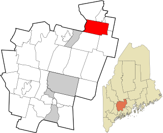
Benton is a town in Kennebec County, Maine, United States. It was formed in 1842, as a subdivision of the town of Clinton. The population was 2,715 at the 2020 census. The town was named for Missouri Senator Thomas Hart Benton.
Purdy is a city in Purdy Township, Barry County, Missouri, United States, on the foothills of the Ozarks, eight miles south of Monett and twelve miles north of Cassville along Highway 37. The population was 1,098 at the 2010 census.
Allenville is a village in Hubble Township in Cape Girardeau County, Missouri, United States. The population was 95 at the 2020 census. It is part of the Cape Girardeau–Jackson, MO-IL Metropolitan Statistical Area.
Gunn City is a village in Cass County, Missouri, United States. The population was 118 at the 2010 census. It is part of the Kansas City metropolitan area.
Missouri City is a city in Clay County, Missouri, United States. The population was 217 at the 2020 census. It is part of the Kansas City metropolitan area.
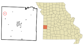
Rives is a town in Dunklin County, Missouri, United States. The population was 63 at the 2010 census.
Grain Valley is a city in Jackson County, Missouri, United States. Grain Valley is located in the Kansas City Metropolitan Area and is a suburb of Kansas City. The population was 12,854 at the 2010 census and an estimated 15,627 in 2020. It is 23 miles (37 km) east of downtown Kansas City.
Lewistown is a city in Lewis County, Missouri, United States. The population was 521 at the 2020 census. It is part of the Quincy, IL–MO Micropolitan Statistical Area. It is located on Missouri Route 6 near the junction of Route 6 with Missouri Route 16. Lewistown is in the Lewis County C-1 school district.
Marquand is a small city in eastern Madison County, Missouri, United States. The population was 186 at the 2020 census. Marquand was officially recognized and incorporated as a town in 1906.
Bagnell is a town in Miller County, Missouri, United States. The population was 43 at the 2020 census, down from 93 in 2010.
Brumley is a town in Miller County, Missouri, United States. The population was 69 at the 2020 census, down from 91 in 2010.
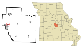
Tuscumbia is a village in and the county seat of Miller County, Missouri, United States. The population was 188 at the 2020 census.
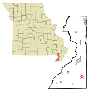
Thayer is a city in Oregon County, Missouri, United States. The population was 1,883 at the 2020 census. Its original name was Augusta.
Chamois is a city in Osage County, Missouri, United States. The population was 377 at the 2020 census. It is part of the Jefferson City, Missouri Metropolitan Statistical Area.
Green Ridge is a city located along Route 127 in Pettis County, Missouri, United States. The population was 476 at the 2010 census.
Tracy is a city in Platte County, Missouri within the United States, located along the Platte River. The population was 269 at the 2020 census. The city is part of the Kansas City metropolitan area.
Lowry City is a city in St. Clair County, Missouri, United States. The population was 613 at the 2020 census. Lowry City is the city where the Ozark Mountains meet the Great Plains.
Stotesbury is a village in northwest Vernon County, Missouri, United States. The population was 18 at the 2010 census.
Williamsville is a city in Wayne County, Missouri, United States, along the Black River. The population was 279 at the 2020 census.
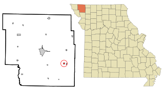
Gilman City is a city in southeastern Harrison and extending into northeastern Daviess counties in the U.S. state of Missouri. The population was 329 at the 2020 census.