
Dahod is a city on the banks of the Dudhimati River in Dahod District in the State of Gujarat, India. It is said that it has taken its name from Saint Dadhichi, who had an Ashram on the bank of Dudhumati river. The city serves as District Headquarters for Dahod District. It is 214 kilometres (133 mi) from Ahmedabad and 159 kilometres (99 mi) from Vadodara. It is also known as Dohad.

Godhra is a road and rail junction and a commercial centre for timber and agricultural produce. Industries include oilseed pressing, flour milling, and glass manufacture. Godhra is a Municipality in Panchmahal district in Indian state of Gujarat. It is the administrative headquarters of the Panchmahal district. Originally the name came from gou which means "cow" and dhara which has two meanings: one in Sanskrit which means "hold" or "land" and the other in Hindi which means "flow": It means the Land of the Cow.

Panchmahal, also Panch Mahals, is a district in the eastern portion of Gujarat State western India. Panch-mahal means "five tehsils/talukas", and refers to the five sub-divisions that were transferred by the Maharaja Jivajirao Scindia of Gwalior State to the British: Godhra, Dahod, Halol, Kalol and Jhalod, ]. The district had a population of 2,390,776 of which 12.51% were urban as of 2001. Headquarters: Godhra.

Gandhidham is a city in the Kutch District of Gujarat state of India. The town was created in the early 1950s for the resettlement of the refugees from Sindh in the aftermath of the partition of India. It was named after Mahatma Gandhi, the father of the Indian nation. Gandhidham is an economic capital of Kutch and it is a fast developing city in Gujarat state. A growing retirement and family city, Gandhidham is the 8th most populous city in the state of Gujarat. The city is a popular destinations for conventions, business, and meetings.

Surajpur is a city and a nagar palika parishad situated in the bank of Rihand River in Surajpur district of Chhattisgarh state in central India. It is the administrative headquarters of the Surajpur district, located 256 km North from the state headquarters Raipur. The National Highway 43 has its route through Surajpur.

Mandi Bamora' is a census town in Sagar district in the state of Madhya Pradesh, India. This place has a railway station Mandi Bamora. Mandi Bamora located as half- half way in two different district Sagar and Vidisha. Its tehsil is Bina. Mandi Bamora is very famous as a name "Great country" because two different dist boundary separate as Bamora-Sihora. In Bamora mostly Hindu, Jain and all other caste's peoples are living. In Sihora, Vidisha district mostly Muslims are living. But its Unity is always unique and better than any other place.
Halol is a city and a municipality (tehsil) in Panchmahal district in the Indian state of Gujarat. Located in western India, it has an average elevation of 499 metres (1637 feet).

Kalol is a city in Gandhinagar district in the Indian state of Gujarat, located alongside Gujarat State Highway 41 between the cities of Mehsana and Ahmedabad.
Karera is a municipality or Nagar Palika in the Shivpuri district of the Indian state of Madhya Pradesh.
Mahemdavad is a town with municipality in the Kheda district in the Indian state of Gujarat. Mahemdavad is situated on the Vatrak River bank. Nearest City is Kheda
Mahuva is a town and subdistrict of Bhavnagar District, in the state of Gujarat, India. Located on the coast of the Arabian Sea, Mahuva is known for its mild weather and green, lush surroundings, including many coconut tree plantations. The town is a part of the Saurashtra region, and is known as the Kashmir of Saurashtra. Mahuva is also known for wooden toys, raw onions, groundnuts, and a local variety of mango called the Jamadar. The region is home to a thriving agribusiness industry, particularly enterprises that dehydrate vegetables such as garlic and onions for use in processed foods.
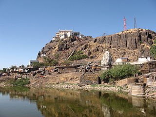
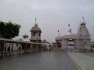
Pavagadh is a Hill Station, and a Municipality in Panchmahal district about 46 kilometres (29 mi) away from Vadodara in Gujarat state in western India. It is known for a famous Mahakali temple which draws thousands of pilgrims every day. It is a tribal area populated predominantly by the Rathwas. The area of this locality Champaner-Pavagadh Archaeological Park was inscribed by UNESCO as a World Heritage Site in 2004.
Pavagadh

Shanti Express is a daily express train offered by Western Railways in India. It runs between Indore Junction of Indore City in the state of Madhya Pradesh and Gandhinagar, the capital of Gujarat. The name Shanti means 'peace' which reflects the peace messages given by the father of the nation Mahatma Gandhi.
Peepal Khoont mainly known as Pipalkhunt [पीपलखूंट] is a Tehsil Headquarter and Panchayat Samiti of the Pratapgarh district of Rajasthan state. It is a sub-division among the 5 sub-divisions of the Pratapgarh district. The main market is called Sadar Bajar. It is situated on National Highway 113. Pipalkhunt is a town located on the Banswara - Jaipur Expressway surrounded by the hills, plants and trees. The town is situated on the bank of the Mahi River.
Nizar (Nijhar) is one of the 5 tehsils in Tapi district in the Indian state of Gujarat. Nizar was separated from Surat district in 2007 while Tapi district was formed. Nizar is located in the South Gujarat, about 172 km from Surat bordering Nandurbar district of Maharashtra.The official language is Gujarati.
Ahmedabad Diocese is a diocese of the Malankara Orthodox Syrian Church also known as the Indian Orthodox Church located at Ahmedabad, Gujarat.
Sagbara is a taluka in Narmada district, Gujarat, India. Its location is at NH-753B Ankleshwar-Valia-Netrang-Dediapada-Sagbara up to State Border to Akkalkuva in Maharashtra Peoples: Adiwasi-schedule tribes, Hindu, Muslim, Marathi and also Christians.
Rupal is a village in Gandhinagar District of Gujarat state, India. It is located 13 km towards north from District headquarters Gandhinagar. Gujarati is the local language here.
Derol or Dedol is a village and former princely state in Gujarat, western India.

Mahemadavad Kheda Road railway station is a railway station on the Western Railway network in the state of Gujarat, India. Mahemadavad Kheda Road railway station is 18 km far away from Nadiad railway station. Passenger, MEMU and few Express/Superfast trains halt at Mahemadavad Kheda Road railway station. This railway station's nearest city is Kheda.
