A Postal Index Number (PIN), or sometimes redundantly a PIN code, is a code in the post office numbering or postal code system used by India Post, the Indian postal entity. The code is six digits long.

Malaj Khand is a town and a municipality in Balaghat district in the Indian state of Madhya Pradesh. This town has the biggest open copper mines in Asia and most of its population are the employed by the mines.
Pan bazar is a locality situated near 'James Street' Secunderabad, Telangana, India. Pan bazar is a residential and commercial area in the heart of the city.

Kinnya or Kinya is a village in Dakshina Kannada district of Karnataka state, India. The Talapady Durga Parameshwari Temple is in this village .The village lies near Talapadi village. It is located 23 km south of Mangalore city. In local Tulu language Kinya means small. The Durga Parameshwari Temple was recently renovated in the year 2015. The village code is 02699400 as per Karnataka Administrative atlas 2001 published by DCO of Karnataka state. Pincode of Kinya village post office is 575023.

Nagole is a residential and commercial locality in Ranga Reddy, Telangana, India

Mathikere is a residential area located in Bangalore City, Karnataka, India. It is known for its locating near the Jayaprakash Narayan Biodiversity Park, one of the most beloved parks of Bangalore suburb population. An engineering college, the M.S. Ramaiah Institute of Technology (MSRIT), is situated in Mathikere. Muthyalanagar is a neighbouring area. A village in early 60's, started as a suburb settlement for people migrating during the industrial revolution in Peenya, establishment and expansion of PSUs. Mathikere is surrounded by lot of green spaces in its vicinity like IISc, ISRO, BEL, HMT, BHEL, NIAS, CPRI, Forest Dept etc making the surrounding cooler throughout the year.

Ekkattuthangal, also known as Ekkaduthangal or Ekkatuthangal, is a neighborhood in Chennai city, Tamil Nadu, India. It is surrounded by Jafferkhanpet, Guindy and Ramapuram. Area pincode is 600032, and previously it was 600097.
Kamargaon is a village on the Pune to Ahmednagar State Highway in India. There is a windmill farm 20 km outside town. The village deity is Kamaksha Devi. Pincode of Kamargaon is 414005
Ernavoor, also spelled Ernavur, is a settlement in North Chennai, the largest city in the southern Indian state of Tamil Nadu. It lies in the postal area of Ennore Thermal Station, with pincode 600057. It lies between Ennore and Manali. It is well connected to other parts of Chennai by bus and rail. It has many industries such as ITC, Wimco etc and it is a developing area. It has many residential posh streets with good maintained roads, LED street lights, water lines, daily garbage cleaning and all necessary amenities.
Kharna is an area located in Ahmedabad, India.
Kovur is a town in the Kanchipuram district of the Indian state of Tamil Nadu. The town is a suburb of Chennai and is situated at a distance of about 22 kilometres from Chennai and 5 kilometres from Porur(Chennai) on the Porur-Kundrathur road.
Dewaitha is a village in Dildarnagar Kamsar in the Ghazipur district, Indian state of Uttar Pradesh.

Pahrajwas is a village in Jatusana block of Rewari district of Haryana. It has 188 households. Male Population is 407 and Female Population is 381, Total Population is 788 It is a village in Rewari tehsil. 123035 is its Pincode.
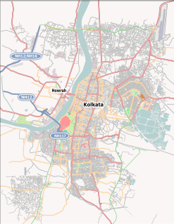
Bartala is a neighbourhood of Kolkata city in Kolkata district, in West Bengal state of India. It is situated at southern part of Kolkata near to Metiabruz and Garden Reach in the east and Akra Phatak on the west. The area is populated with Bengali speaking people mainly Muslims. The area has a post office named Bartala Post office with Pin code 700018.
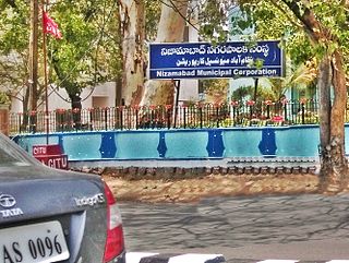
The Nizamabad Municipal Corporation is the local governing body, administering the city of Nizamabad in the Indian state of Telangana. It is the third largest city in the state after Hyderabad and Warangal. As of 2011 census, the municipal corporation had a population of 310,467. The municipal corporation consists of democratically elected members, is headed by a mayor and administers the city's governance, infrastructure and administration.
Koduvalli (கோடுவள்ளி) is a place in the Thiruvallur district of Tamil Nadu state, India.
Naganahalli is a small village in Mysuru district of Karnataka state, India.

Byadara Halli is a village in Mandya district of Karnataka state, India.

Indira Nagar is a residential area in the Indian city of Srinagar in the state of Jammu and Kashmir. It used to be a lake before but now only few hundred meters of the lake is left.
Jawahar Nagar is the notified area in the municipal committee of Srinagar, in the Indian state of Jammu and Kashmir. It comes under the Amira Kadal Constituency. Jawahar Nagar is a posh locality in the civil line area of Srinagar. The pincode of Jawahar Nagar is 190008. Jawahar Nagar is considered one of the many best residential places in Srinagar. The airport is located at a distance of 9.3 km. Jawahar Nagar area was heavily damaged by the 2014 Kashmir floods, it was one of the worst affected areas due to flood. There are 2 Branches of Jammu and Kashmir Bank one of which is exclusively for women.


