Kanaya-juku

Last updated
Kanaya-juku in the 1830s, as depicted by Hiroshige in The Fifty-three Stations of the Tokaido Tokaido24 Kanaya.jpg
Kanaya-juku in the 1830s, as depicted by Hiroshige in The Fifty-three Stations of the Tōkaidō
Hokusai The Fuji from Kanaya on the Tokaido.jpg
Hokusai

Kanaya-juku(金谷宿,Kanaya-juku) was the twenty-fourth of the fifty-three stations of the Tōkaidō. It is located in what is now part of Shimada, Shizuoka Prefecture, Japan. During the Edo period, it was the easternmost post station of Tōtōmi Province.

53 Stations of the Tōkaidō Wikimedia list article

The 53 Stations of the Tōkaidō are the rest areas along the Tōkaidō, which was a coastal route that ran from Nihonbashi in Edo to Sanjō Ōhashi in Kyoto.

Tōkaidō (road) road of premodern Japan. sometimes mean region (see Q1196306)

The Tōkaidō road (東海道), which roughly means "eastern sea route," was the most important of the Five Routes of the Edo period in Japan, connecting Kyoto to Edo. Unlike the inland and less heavily travelled Nakasendō, the Tōkaidō travelled along the sea coast of eastern Honshū, hence the route's name.

Shimada, Shizuoka City in Chūbu, Japan

Shimada is a city located in Shizuoka Prefecture, Japan.

Contents

History

Kanaya-juku was built up on the right bank of the Ōi River across from Shimada-juku. There were over 1,000 buildings in the post town, including three honjin , one sub-honjin and 51 hatago . [1] Travelers had an easy travel to Nissaka-shuku, which was about 6.5 km (4.0 mi) away. [1] However, whenever the river's banks overflowed, travelers were not able to pass through Kanaya and on to Shimada-juku, as the Tokugawa shogunate had expressly forbidden the construction of any bridge on the Ōi River.

Ōi River river in Japan

The Ōi River is a river in Shizuoka Prefecture, Japan.

Shimada-juku

Shimada-juku was the twenty-third of the fifty-three stations of the Tōkaidō. It is located in what is now part of Shimada, Shizuoka Prefecture, Japan.

<i>Honjin</i>

Honjin (本陣) is the Japanese word for an inn for government officials, generally located in post stations (shukuba) during the later part of the Edo period.

The classic ukiyo-e print by Andō Hiroshige (Hōeido edition) from 1831–1834 depicts a daimyō procession on sankin-kōtai crossing the river. The daimyō is riding in a kago , held above the water by a makeshift platform carried by numerous porters. His retainers are attempting to wade across the river. In the background, a small village is shown in the foothills.

Ukiyo-e A genre of Japanese art which flourished from the 17th through 19th centuries

Ukiyo-e is a genre of Japanese art which flourished from the 17th through 19th centuries. Its artists produced woodblock prints and paintings of such subjects as female beauties; kabuki actors and sumo wrestlers; scenes from history and folk tales; travel scenes and landscapes; flora and fauna; and erotica. The term ukiyo-e (浮世絵) translates as "picture[s] of the floating world".

<i>Daimyō</i> powerful territorial lord in pre-modern Japan

The daimyō were powerful Japanese feudal lords who, until their decline in the early Meiji period, ruled most of Japan from their vast, hereditary land holdings. In the term, dai (大) means "large", and myō stands for myōden(名田), meaning private land.

<i>Sankin-kōtai</i> daimyōs alternate-year residence in Edo, a policy of the Tokugawa shogunate

Sankin-kōtai was a policy of the Tokugawa shogunate during most of the Edo period of Japanese history. The purpose was to strengthen central control over the daimyōs. It required feudal lords, daimyō, to alternate living for a year in their domain and in Edo, the capital.

Neighboring post towns

Tōkaidō
Shimada-juku - Kanaya-juku - Nissaka-shuku

Further reading

International Standard Book Number Unique numeric book identifier

The International Standard Book Number (ISBN) is a numeric commercial book identifier which is intended to be unique. Publishers purchase ISBNs from an affiliate of the International ISBN Agency.

Related Research Articles

Mishima-shuku

Mishima-shuku was the eleventh of the fifty-three stations of the Tōkaidō during Edo period Japan. It is located in the present-day city of Mishima, in Shizuoka Prefecture.

Fujikawa-shuku

Fujikawa-shuku was the thirty-seventh of the fifty-three stations of the Tōkaidō. It is located in the present-day city of Okazaki, in Aichi Prefecture, Japan. It was approximately 9 kilometres (5.6 mi) from Akasaka-juku, the preceding post station. Another accepted reading for this post town is "Fujikawa-juku."

Kawasaki-juku Second of 53 stations of the Tōkaidō road, in Kawasaki, Japan

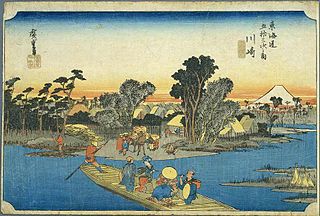
Kawasaki-juku was the second of the fifty-three stations of the Tōkaidō. It is located in Kawasaki-ku in the present-day city of Kawasaki, Kanagawa Prefecture, Japan.

Akasaka-juku (Tōkaidō)

Akasaka-juku was the thirty-sixth of the fifty-three stations of the Tōkaidō. It is located in present-day Toyokawa, Aichi Prefecture, Japan. It was only 1.7 kilometres (1.1 mi) from Goyu-juku, the preceding post station.

Kuwana-juku

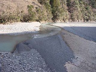
Kuwana-juku was the forty-second of the fifty-three stations of the Tōkaidō. It is located in former Ise Province in what is now part of the city of Kuwana, in Mie Prefecture, Japan. It was located on the western shores of the Ibi River and is considered to be the easternmost point of the Kansai dialect. It is 28 km from the preceding post station of Miya-juku.

Mitsuke-juku

Mitsuke-juku was the twenty-eighth of the fifty-three stations of the Tōkaidō. It is located in what is now the central part of the city of Iwata, Shizuoka Prefecture, Japan. The post station received its name, which means "with a view," because it was the first place from which Mount Fuji could be seen by travelers coming from Kyoto.

Hamamatsu-juku

Hamamatsu-juku was the twenty-ninth of the fifty-three stations (shukuba) of the Tōkaidō. It is located in what is now Hamamatsu's Naka-ku in Shizuoka Prefecture, Japan.

Totsuka-juku

Totsuka-juku was the fifth of the fifty-three stations (shukuba) of the Tōkaidō. It was the eastern-most post station in Sagami Province. It is now located in Totsuka-ku in the present-day city of Yokohama, Kanagawa Prefecture, Japan.

Fujisawa-shuku

Fujisawa-shuku was the sixth of the fifty-three stations of the Tōkaidō. It is located in the present-day city of Fujisawa, Kanagawa Prefecture, Japan.

Goyu-shuku

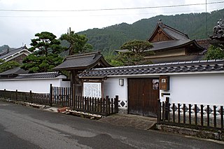
Goyu-shuku was the thirty-fifth of the fifty-three stations of the Tōkaidō. It is located in Goyu-chō in the city of Toyokawa, Aichi Prefecture, Japan. A pine tree colonnade, one of the few remnants from the Edo period post town, is a well-known tourist spot. It was approximately 10.4 kilometres (6.5 mi) from Yoshida-juku, the preceding post station.

Hiratsuka-juku

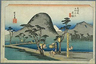
Hiratsuka-juku was the seventh of the fifty-three stations (shukuba) of the Tōkaidō. It is located in the present-day city of Hiratsuka, Kanagawa Prefecture, Japan.

Okitsu-juku

Okitsu-juku was the seventeenth of the fifty-three stations of the Tōkaidō. It is located in what is now part of the Shimizu-ku area of Shizuoka, Shizuoka Prefecture, Japan.

Numazu-juku

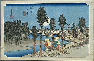
Numazu-juku was the twelfth of the fifty-three stations of the Tōkaidō. It is located in the present-day city of Numazu, Shizuoka Prefecture, Japan.

Nissaka-shuku

Nissaka-shuku was the twenty-fifth of the fifty-three stations of the Tōkaidō. It is located in what is now part of the city of Kakegawa, Shizuoka Prefecture, Japan.

Ejiri-juku

Ejiri-juku was the eighteenth of the fifty-three stations of the Tōkaidō. It is one of four former post stations located in what is now part of the Shimizu-ku area of Shizuoka, Shizuoka Prefecture, Japan. It was 3.4 kilometers from Okitsu-juku, the preceding post station.

Kakegawa-juku

Kakegawa-juku was the twenty-sixth of the fifty-three stations of the Tōkaidō. It is located in what is now the city of Kakegawa, Shizuoka Prefecture, Japan.

Futagawa-juku

Futagawa-juku was the thirty-third of the fifty-three stations of the Tōkaidō. It is located in what is now the city of Toyohashi, Aichi Prefecture, Japan. It was the eastern most post station in Mikawa Province.

Yoshida-juku

Yoshida-juku was the thirty-fourth of the fifty-three stations of the Tōkaidō. It is located in the center of what is now the city of Toyohashi, Aichi Prefecture, Japan. It was 287 kilometres (178 mi) from the start of the route in Edo's Nihonbashi and 6.1 kilometres (3.8 mi) from Futagawa-juku to the east and 10.5 kilometres (6.5 mi) from Goyu-shuku to the west.

References

Commons-logo.svg Media related to Kanaya-juku at Wikimedia Commons

  1. 1 2 Ochakaidō: History of Kanaya-juku. Ochakaidō Cultural Association. November 29, 2007.