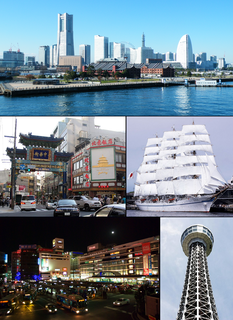
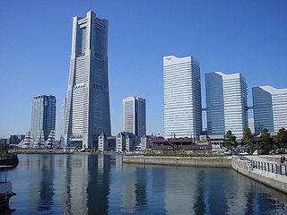
Yokohama is the second largest city in Japan by population, and the most populous municipality of Japan. It is the capital city of Kanagawa Prefecture. It lies on Tokyo Bay, south of Tokyo, in the Kantō region of the main island of Honshu. It is a major commercial hub of the Greater Tokyo Area.

Kawasaki-ku (川崎区) is one of the seven wards of the city of Kawasaki in Kanagawa Prefecture, Japan. As of 2010, the ward had an estimated population of 216,826 and a density of 5,530 persons per km². The total area was 39.21 square kilometres (15.14 sq mi). Kawasaki-ku has the home to the second largest Koreatown in Japan.

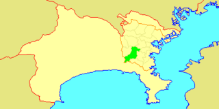
Saiwai-ku (幸区) is one of the 7 wards of the city of Kawasaki in Kanagawa Prefecture, Japan. As of 2010, the ward had an estimated population of 153,255 and a density of 15,250 persons per km². The total area was 10.05 km².

Tsurumi-ki (鶴見区) is one of the 18 ku (wards) of the city of Yokohama in Kanagawa Prefecture, Japan. As of 2010, the ward had an estimated population of 270,433 and a density of 8,140 persons per km². The total area was 33.23 km².

Hodogaya-ku (保土ケ谷区) is one of the 18 wards of the city of Yokohama in Kanagawa Prefecture, Japan. As of 2010, Hodogaya Ward had an estimated population of 205,887 and a density of 9,400 inhabitants per square kilometer (24,000/sq mi). The total area was 21.91 km2 (8.46 sq mi).
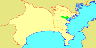
Nishi-ku (西区) is one of the 18 wards of the city of Yokohama in Kanagawa Prefecture, Japan. As of 2010, the ward had an estimated population of 93,027 and a density of 13,210 persons per km². The total area was 7.04 km².

Seya-ku (瀬谷区) is one of the 18 wards of the city of Yokohama in Kanagawa Prefecture, Japan. As of 2010, the ward had an estimated population of 126,839 and a density of 7,390 persons per km2. The total area was 17.16 km2.
Totsuka-ku (戸塚区) is one of the 18 wards of the city of Yokohama in Kanagawa Prefecture, Japan. As of 2010, the ward had an estimated population of 273,418 and a density of 7,640 persons per km². The total area was 35.70 km².

Kannai (関内) is a district in Naka Ward, Yokohama, Japan, bounded by the Ōoka River, JR Negishi Line, Nakamura River, and Yokohama waterfront. "Kannai" is not an official name of the area, but the common term of reference has been in use for over a century.
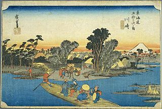
Kawasaki-juku was the second of the fifty-three stations of the Tōkaidō. It is located in Kawasaki-ku in the present-day city of Kawasaki, Kanagawa Prefecture, Japan.

Hodogaya-juku was the fourth of the fifty-three stations of the Tōkaidō. It is located in Hodogaya-ku in the present-day city of Yokohama, Kanagawa Prefecture, Japan. Occasionally, it is also written as 保土ヶ谷宿.

Hakone-juku was the tenth of the fifty-three stations of the Tōkaidō. It is located in the present-day town of Hakone in Ashigarashimo District, Kanagawa Prefecture, Japan. At an elevation of 725m, it is the highest post station on the entire Tōkaidō and was even difficult for the bakufu to maintain.

Odawara-juku was the ninth of the fifty-three stations of the Tōkaidō. It is located in the present-day city of Odawara, Kanagawa Prefecture, Japan. It was the first post station in a castle town that travelers came to when they exited Edo in Edo period Japan.

Totsuka-juku was the fifth of the fifty-three stations (shukuba) of the Tōkaidō. It was the eastern-most post station in Sagami Province. It is now located in Totsuka-ku in the present-day city of Yokohama, Kanagawa Prefecture, Japan.
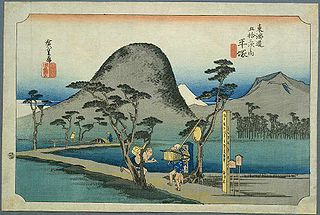
Hiratsuka-juku was the seventh of the fifty-three stations (shukuba) of the Tōkaidō. It is located in the present-day city of Hiratsuka, Kanagawa Prefecture, Japan.

Ōiso-juku was the eighth of the fifty-three stations (shukuba) of the Tōkaidō. It is located in the present-day town of Ōiso, located in Naka District, Kanagawa Prefecture, Japan.