Naka-ku, Yokohama

Last updated • 4 min readFrom Wikipedia, The Free Encyclopedia
Naka
中区
Naka Ward
YamashitakoenJP14Apr05.jpg
Yamashita Park and Yokohama Marine Tower
Yokohama-Naka-logo.png
Naka-ku, Yokohama
Yokohama-Naka-ku.PNG
Location of Naka in Kanagawa
Japan location map with side map of the Ryukyu Islands.svg
Red pog.svg
Naka
 
Coordinates: 35°26′40″N139°38′36″E / 35.44444°N 139.64333°E / 35.44444; 139.64333
CountryJapan
Region Kantō
Prefecture Kanagawa
City Yokohama
Area
  Total
20.86 km2 (8.05 sq mi)
Population
 (February 2010)
  Total
146,563
  Density7,030/km2 (18,200/sq mi)
Ethnic groups
Time zone UTC+9 (Japan Standard Time)
- Flower Tulip
Address35 Nippon Odori, Naka-ku, Yokohama-shi, Kanagawa-ken
231-0021
Website www.city.yokohama.lg.jp/naka
Naka Ward Office Yokohamanakaku.jpg
Naka Ward Office

Naka-ku (中区) is one of the 18 wards of the city of Yokohama in Kanagawa Prefecture, Japan. In 2010, the ward had an estimated population of 146,563 and a population density of 7,080 persons per km². The total area was 20.86 km².[ citation needed ]

Contents

Geography

Naka Ward is located in eastern Kanagawa Prefecture, and east of the geographic center of the city of Yokohama. Its name means "middle ward." In the low-lying Northern district, commonly referred to as Kannai, it hosts the Yokohama city hall and the headquarters of the Kanagawa prefectural government. The central part of the ward includes elevated ground; this area, known as Yamate, has long been a residential area. Along the shore lies reclaimed land upon which port facilities, part of the Minato Mirai 21 complex, and Yamashita Park were built. To the south are the piers, oil refineries and the central port of Yokohama. The Nakamura River, a branch of the Ōoka River, cuts across the northern part of the ward. The northernmost and southernmost points are upland.

Surrounding wards

History

In the Edo period, the area of present-day Naka-ku was part of the tenryō territory in Musashi Province controlled directly by the Tokugawa shogunate, but administered through various hatamoto . Before 1667 much of the area in Naka-ku and Minami-ku was submerged and a part of a lagoon. In that year, a large scale reclamation project, the Yoshida Shinden was completed. During this period Naka-ku developed into a largely agricultural area compromised reclaimed paddy fields for rice production. [1] In the Bakumatsu Period, the signing of the Kanagawa Treaty provided for the opening of treaty ports, and the area of what is now central Naka Ward was designated as open to foreign settlement in 1859. The Yokohama Cricket Club (now known as the Yokohama Country & Athletic Club) was established in 1868. Yokohama Chinatown was also established during this period.

After the Meiji Restoration, the area was transferred to the new Kuraki District in Kanagawa Prefecture. Yokohama's wards were established on October 10, 1927, with this area becoming Naka Ward. The 1923 Great Kantō earthquake devastated downtown Yokohama. Yamashita Park was established in 1930 with landfill from the earthquake rubble. In December 1943, Minami Ward was separated from Naka Ward, which also gave up some territory to Kanagawa Ward and Hodogaya Ward. Nishi Ward was separated from Naka Ward in 1944. During World War II, the Yokohama Air Raid of May 29, 1945 left 14,157 people dead, injured, or missing. After the surrender of Japan, some 74% of the land, 90% of port area in Naka Ward was occupied by the American military. The last of this territory was not returned to Japan until March 31, 1982.

Economy

Naka Ward is a regional commercial center and the old main business district of Yokohama.

Yokohama's day labourers concentrate in the Kotobuki-cho ward near the Ishikawachō Station. [2] Historically, most used to work at the harbour, with 5500 labourers in 1982. [2]

Transportation

Rail

Highways

Ferry

Education

Colleges and universities:

The Kanagawa Prefectural Board of Education operates prefectural high schools:

The Yokohama Municipal Board of Education  [ ja ] operates municipal high schools:

The municipal board of education operates public elementary and junior high schools.

Junior high schools: [3]

Elementary schools: [4]

Additionally, the zones of Azuma Elementary School (東小学校), Ishikawa Elementary School (石川小学校), Minami Yoshida Elementary School (南吉田小学校), Minatomiraihoncho Elementary School (みなとみらい本町小学校), and Negishi Elementary School (根岸小学校), all with campuses outside of Naka-ku, include portions of Naka-ku. [5]

Private primary and secondary schools:

Local attractions

Hikawa Maru at Yamashita Park HikawamaruAtYokohama.JPG
Hikawa Maru at Yamashita Park
Yokohama Chinatown Chinatown in Yokohama 10.jpg
Yokohama Chinatown
Yokohama Baseball Stadium Yokohama Stadium 2007 -3.jpg
Yokohama Baseball Stadium

Events

Notable people

Related Research Articles

<span class="mw-page-title-main">Yokohama</span> Designated city in Kantō, Japan

Yokohama is the second-largest city in Japan by population and by area, and the country's most populous municipality. It is the capital and most populous city in Kanagawa Prefecture, with a population of 3.7 million in 2023. It lies on Tokyo Bay, south of Tokyo, in the Kantō region of the main island of Honshu. Yokohama is also the major economic, cultural, and commercial hub of the Greater Tokyo Area along the Keihin Industrial Zone.

<span class="mw-page-title-main">Yamate</span> District in Yokohama, Japan

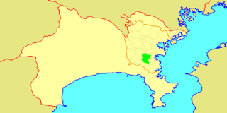
Yamate (山手) is the name of a historic neighbourhood in Naka-ku, Yokohama often referred to in English as The Bluff. The neighbourhood is famous as having been a foreigners' residential area in the Bakumatsu, Meiji and Taishō periods. While still dominantly residential in character, with views over downtown Yokohama, historic residential properties, ornamental gardens and public parks, the area is also a popular visitor destination.

<span class="mw-page-title-main">Minato Mirai 21</span> Central business district of Yokohama, Japan

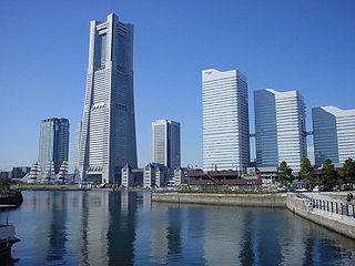
Minato Mirai 21, often known as simply Minato Mirai and abbreviated as MM, is the central business district of Yokohama, Japan. Initially developed in the 1980s, Minato Mirai 21 was designed as a large master-planned development and new urban center planned to connect Yokohama's traditionally important areas and commercial centers of Kannai and the Yokohama Station area.

<span class="mw-page-title-main">Tsuzuki-ku, Yokohama</span> Ward in Kantō, Japan

Tsuzuki-ku (都筑区) is one of the 18 wards of the city of Yokohama in Kanagawa Prefecture, Japan. As of 2010, the ward had an estimated population of 199,258 and a density of 7,130 persons per km2. The total area was 27.93 km2.

<span class="mw-page-title-main">Isogo-ku, Yokohama</span> Ward in Kantō, Japan

Isogo-ku (磯子区) is one of the 18 wards of the city of Yokohama in Kanagawa Prefecture, Japan. As of 2010, the ward has an estimated population of 163,406 and a population density of 8,520 persons per km2. The total area is 19.17 km2.

<span class="mw-page-title-main">Kanazawa-ku, Yokohama</span> Ward in Kantō, Japan

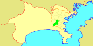
Kanazawa-ku (金沢区) is one of the 18 wards of the city of Yokohama in Kanagawa Prefecture, Japan. As of 2010, the ward had an estimated population of 209,565 and a density of 6,760 persons per km². The total area was 31.01 km2 (11.97 sq mi). The ward symbol, established 1987, expresses the image of sea, waves, and a sea gull.

<span class="mw-page-title-main">Hodogaya-ku, Yokohama</span> Ward in Kantō, Japan

Hodogaya-ku (保土ケ谷区) is one of the 18 wards of the city of Yokohama in Kanagawa Prefecture, Japan. As of 2010, Hodogaya Ward had an estimated population of 205,887 and a density of 9,400 inhabitants per square kilometer (24,000/sq mi). The total area was 21.91 km2 (8.46 sq mi).

<span class="mw-page-title-main">Izumi-ku, Yokohama</span> Ward in Kantō, Japan

Izumi-ku (泉区) is one of the 18 wards of the city of Yokohama in Kanagawa Prefecture, Japan. In 2010 the ward had an estimated population of 155,674 and a density of 6,620 persons per km². The total area was 23.51 km².

<span class="mw-page-title-main">Kōhoku-ku, Yokohama</span> Ward in Kantō, Japan

Kōhoku-ku (港北区) is one of the 18 wards of the city of Yokohama in Kanagawa Prefecture, Japan. As of March 1, 2012, the ward had an estimated population of 332,488, with 156,198 households and a population density of 10,588.79 persons per km2. The total area was 31.40 km2. Kōhoku Ward has the largest population of Yokohama's 18 wards, and ranks second to Naka Ward in the total number of workplaces.

<span class="mw-page-title-main">Nishi-ku, Yokohama</span> Ward in Kantō, Japan

Nishi-ku (西区) is one of the 18 wards of the city of Yokohama in Kanagawa Prefecture, Japan. As of 2010, the ward had an estimated population of 93,027 and a density of 13,210 persons per km². The total area was 7.04 km².

<span class="mw-page-title-main">Kōnan-ku, Yokohama</span> Ward in Kantō, Japan

Kōnan-ku (港南区) is one of the 18 wards of the city of Yokohama in Kanagawa Prefecture, Japan. As of 2010, the ward had an estimated population of 221,536 and a density of 11,150 persons per km2. The total area was 19.87 km2.

<span class="mw-page-title-main">Asahi-ku, Yokohama</span> Ward in Kantō, Japan

Asahi-ku (旭) is one of the 18 wards of the city of Yokohama in Kanagawa Prefecture, Japan. As of 2010, the ward has an estimated population of 249,045 and a population density of 7,600 persons per km2. The total area is 32.77 km2.

<span class="mw-page-title-main">Kanagawa-ku, Yokohama</span> Ward in Kantō, Japan

Kanagawa-ku (神奈川区) is one of the 18 wards of the city of Yokohama in Kanagawa Prefecture, Japan. As of 2010, the ward had an estimated population of 230,401 and a density of 9,650 persons per km2. The total area was 23.88 km2.

<span class="mw-page-title-main">Minami-ku, Yokohama</span> Ward in Kantō, Japan

Minami-ku (南区) is one of the 18 wards of the city of Yokohama in Kanagawa Prefecture, Japan. As of 2010, the ward had an estimated population of 197,019 and a density of 15,550 persons per km². The total area was 12.67 km².

<span class="mw-page-title-main">Sakae-ku, Yokohama</span> Ward in Kantō, Japan

Sakae-ku (栄区) is one of the 18 wards of the city of Yokohama in Kanagawa Prefecture, Japan. As of 2010, the ward had an estimated population of 124,845 and a density of 6,750 persons per km². The total area was 18.55 km².

<span class="mw-page-title-main">Totsuka-ku, Yokohama</span> Ward in Kantō, Japan

Totsuka-ku (戸塚区) is one of the 18 wards of the city of Yokohama in Kanagawa Prefecture, Japan. As of 2010, the ward had an estimated population of 273,418 and a density of 7,640 persons per km2. The total area was 35.70 km2.

<span class="mw-page-title-main">Motomachi, Yokohama</span> District of Yokohama, Japan

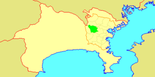
Motomachi is a district in Naka Ward in Yokohama, Japan. It is located immediately west of Yamate and east of Chinatown. It consists of the Motomachi Shopping Street, which is a five-block-long stretch of boutiques and shops. It is known in Japan for its cosmopolitan atmosphere, original fashion, and Western influence.

<span class="mw-page-title-main">Isezakichō</span> District of Naka-ku, Yokohama, Japan

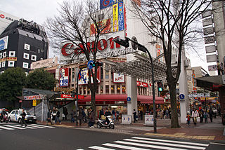
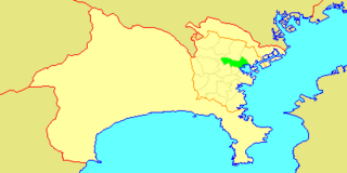
Isezakichō (伊勢佐木町) is a district of Naka Ward in Yokohama, Japan, consisting mainly of the Isezakichō Shopping Street. The shopping street is 1.2 km (0.75 mi) long, running from Isezakicho 1-chōme in the northeast, to Isezakicho 7-chōme in the southwest, approximately parallel to the course of the Ōoka River.

<span class="mw-page-title-main">Kannai</span>

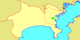
Kannai (関内) is a district in Naka Ward, Yokohama, Japan, bounded by the Ōoka River, JR Negishi Line, Nakamura River, and Yokohama waterfront. "Kannai" is not an official name of the area, but the common term of reference has been in use for over a century.

References

  1. Saito, Joji; Ichikawa, Yasuo; Yamashita, Kiyomi (2011). "横浜における外国人居留地および中華街の変容" (PDF). 地理空間. 4 (1): 56–69.
  2. 1 2 "Yama—Attack to Attack: In Sequence".
  3. "R04-02-30_naka.xlsx". City of Yokohama. Retrieved 2022-10-29. - From this link
  4. "R04-01-30_naka.xlsx". City of Yokohama. Retrieved 2022-10-29. - From this link
  5. "小・中学校等の通学区域一覧(通学規則 別表)". City of Yokohama. Retrieved 2022-10-21.