Mishima-shuku

Last updated
Mishima-shuku in the 1830s, as depicted by Hiroshige in the Hoeido edition of The Fifty-three Stations of the Tokaido (1831-1834) Tokaido11 Mishima.jpg
Mishima-shuku in the 1830s, as depicted by Hiroshige in the Hōeidō edition of The Fifty-three Stations of the Tōkaidō (1831–1834)

Mishima-shuku(三島宿,Mishima-shuku) was the eleventh of the fifty-three stations of the Tōkaidō during Edo period Japan. It is located in the present-day city of Mishima, in Shizuoka Prefecture.

53 Stations of the Tōkaidō Wikimedia list article

The 53 Stations of the Tōkaidō are the rest areas along the Tōkaidō, which was a coastal route that ran from Nihonbashi in Edo to Sanjō Ōhashi in Kyoto.

Tōkaidō (road) road of premodern Japan. sometimes mean region (see Q1196306)

The Tōkaidō road (東海道), which roughly means "eastern sea route," was the most important of the Five Routes of the Edo period in Japan, connecting Kyoto to Edo. Unlike the inland and less heavily travelled Nakasendō, the Tōkaidō travelled along the sea coast of eastern Honshū, hence the route's name.

Edo period period of Japanese history

The Edo period or Tokugawa period (徳川時代) is the period between 1603 and 1868 in the history of Japan, when Japanese society was under the rule of the Tokugawa shogunate and the country's 300 regional daimyō. The period was characterized by economic growth, strict social order, isolationist foreign policies, a stable population, "no more wars", and popular enjoyment of arts and culture. The shogunate was officially established in Edo on March 24, 1603, by Tokugawa Ieyasu. The period came to an end with the Meiji Restoration on May 3, 1868, after the fall of Edo.

Contents

History

In Mishima-juku, there were two honjin and 74 other minor inns for travelers. Mishima was the only post station located within Izu Province. Mishima was the traditional provincial capital of Izu from the Nara period and the location of a major Shinto shrine. Until 1759, Mishima was the location of the daikanshō , the seat of government for the hatamoto -class retainer appointed by the Tokugawa shogunate to rule over Izu Province.

<i>Honjin</i>

Honjin (本陣) is the Japanese word for an inn for government officials, generally located in post stations (shukuba) during the later part of the Edo period.

<i>Shukuba</i> post stations of Japan in the Edo period

Shukuba (宿場) were post stations during the Edo period in Japan, generally located on one of the Edo Five Routes or one of its sub-routes. They were also called shuku-eki (宿駅). These post stations were places where travelers could rest on their journey around the nation. They were created based on policies for the transportation of goods by horseback that were developed during the Nara and Heian periods.

Izu Province province of Japan

Izu Province was a province of Japan in the area of Shizuoka Prefecture. Izu bordered on Sagami and Suruga Provinces. Its abbreviated form name was Zushū (豆州).

Additionally, because water flows from Mount Fuji to the town, it was referred to as the "Capital of Water." [1]

Mount Fuji Volcano in Yamanashi and Shizuoka Prefectures, Japan

Mount Fuji, located on Honshū, is the highest volcano in Japan at 3,776.24 m (12,389 ft), 2nd-highest peak of an island (volcanic) in Asia, and 7th-highest peak of an island in the world. It is a dormant stratovolcano that last erupted in 1707–1708. Mount Fuji lies about 100 kilometers (60 mi) south-west of Tokyo, and can be seen from there on a clear day. Mount Fuji's exceptionally symmetrical cone, which is snow-capped for about 5 months a year, is a well-known symbol of Japan and it is frequently depicted in art and photographs, as well as visited by sightseers and climbers.

The classic ukiyo-e print by Andō Hiroshige (Hōeidō edition) from 1831–1834 depicts travelers setting out in the early morning mists. One is mounted, and the other is traveling by kago. The torii of Mishima Taisha shrine is in the background. By contrast, the Kyōka edition of the late 1830s depicts a snow-covered village, with Mount Fuji in the background.

Ukiyo-e A genre of Japanese art which flourished from the 17th through 19th centuries

Ukiyo-e is a genre of Japanese art which flourished from the 17th through 19th centuries. Its artists produced woodblock prints and paintings of such subjects as female beauties; kabuki actors and sumo wrestlers; scenes from history and folk tales; travel scenes and landscapes; flora and fauna; and erotica. The term ukiyo-e (浮世絵) translates as "picture[s] of the floating world".

<i>Torii</i> traditional Japanese gate

A torii is a traditional Japanese gate most commonly found at the entrance of or within a Shinto shrine, where it symbolically marks the transition from the mundane to the sacred.

Neighboring post towns

Tōkaidō
Hakone-juku - Mishima-shuku - Numazu-juku

Further reading

International Standard Book Number Unique numeric book identifier

The International Standard Book Number (ISBN) is a numeric commercial book identifier which is intended to be unique. Publishers purchase ISBNs from an affiliate of the International ISBN Agency.

Related Research Articles

Kawasaki-juku Second of 53 stations of the Tōkaidō road, in Kawasaki, Japan

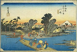
Kawasaki-juku was the second of the fifty-three stations of the Tōkaidō. It is located in Kawasaki-ku in the present-day city of Kawasaki, Kanagawa Prefecture, Japan.

Kuwana-juku

Kuwana-juku was the forty-second of the fifty-three stations of the Tōkaidō. It is located in former Ise Province in what is now part of the city of Kuwana, in Mie Prefecture, Japan. It was located on the western shores of the Ibi River and is considered to be the easternmost point of the Kansai dialect. It is 28 km from the preceding post station of Miya-juku.

Kanaya-juku

Kanaya-juku was the twenty-fourth of the fifty-three stations of the Tōkaidō. It is located in what is now part of Shimada, Shizuoka Prefecture, Japan. During the Edo period, it was the easternmost post station of Tōtōmi Province.

Mitsuke-juku

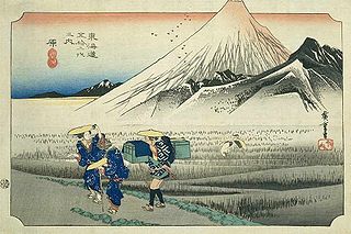
Mitsuke-juku was the twenty-eighth of the fifty-three stations of the Tōkaidō. It is located in what is now the central part of the city of Iwata, Shizuoka Prefecture, Japan. The post station received its name, which means "with a view," because it was the first place from which Mount Fuji could be seen by travelers coming from Kyoto.

Yoshiwara-juku

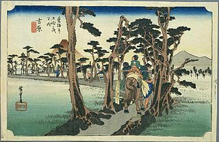
Yoshiwara-juku was the fourteenth of the fifty-three stations of the Tōkaidō. It is located in the present-day city of Fuji, Shizuoka Prefecture, Japan.

Totsuka-juku

Totsuka-juku was the fifth of the fifty-three stations (shukuba) of the Tōkaidō. It was the eastern-most post station in Sagami Province. It is now located in Totsuka-ku in the present-day city of Yokohama, Kanagawa Prefecture, Japan.

Fujisawa-shuku

Fujisawa-shuku was the sixth of the fifty-three stations of the Tōkaidō. It is located in the present-day city of Fujisawa, Kanagawa Prefecture, Japan.

Okazaki-shuku

Okazaki-shuku was the thirty-eighth of the fifty-three stations of the Tōkaidō. It is located in the present-day city of Okazaki, in Aichi Prefecture, Japan.

Yui-shuku

Yui-shuku was the sixteenth of the fifty-three stations of the Tōkaidō. It is located in the Shimizu-ku area of Shizuoka, Shizuoka Prefecture, Japan. It is one of four former post stations located in Shimizu-ku.

Hiratsuka-juku

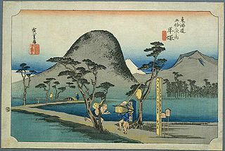
Hiratsuka-juku was the seventh of the fifty-three stations (shukuba) of the Tōkaidō. It is located in the present-day city of Hiratsuka, Kanagawa Prefecture, Japan.

Ōiso-juku

Ōiso-juku was the eighth of the fifty-three stations (shukuba) of the Tōkaidō. It is located in the present-day town of Ōiso, located in Naka District, Kanagawa Prefecture, Japan.

Numazu-juku

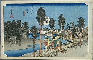
Numazu-juku was the twelfth of the fifty-three stations of the Tōkaidō. It is located in the present-day city of Numazu, Shizuoka Prefecture, Japan.

Hara-juku (Tōkaidō) one of the stations (shukuba) of the Tōkaidō

Hara-juku was the thirteenth of the fifty-three stations of the Tōkaidō. It is located in the present-day city of Numazu, Shizuoka Prefecture, Japan.

Miya-juku

Miya-juku was the forty-first of the fifty-three stations of the Tōkaidō. It is located in former Owari Province in what is now part of the Atsuta-ku section of the city of Nagoya, in Aichi Prefecture, Japan. It was six km from Narumi-juku, the preceding post station.

Kakegawa-juku

Kakegawa-juku was the twenty-sixth of the fifty-three stations of the Tōkaidō. It is located in what is now the city of Kakegawa, Shizuoka Prefecture, Japan.

Chiryū-juku

Chiryū-juku was the thirty-ninth of the fifty-three stations of the Tōkaidō. It is located in the present-day city of Chiryū in Aichi Prefecture, Japan. It was the westernmost post town in Mikawa Province, and was 330 kilometres (210 mi) from Nihonbashi, the start of the Tōkaidō, so it took approximately 10 days to for average travellers to reach.

Fuchū-shuku

Fuchū-shuku was the nineteenth of the fifty-three stations of the Tōkaidō. It is located in what is now part of the Aoi-ku area of Shizuoka, Shizuoka Prefecture, Japan.

Maisaka-juku

Maisaka-juku was the thirtieth of the fifty-three stations of the Tōkaidō. It is located in the western portion of Hamamatsu in Shizuoka Prefecture, Japan. During the Edo period, the area was part of Tōtōmi Province. The kanji for the post station were originally written 舞坂 (Maisaka).

Yoshida-juku

Yoshida-juku was the thirty-fourth of the fifty-three stations of the Tōkaidō. It is located in the center of what is now the city of Toyohashi, Aichi Prefecture, Japan. It was 287 kilometres (178 mi) from the start of the route in Edo's Nihonbashi and 6.1 kilometres (3.8 mi) from Futagawa-juku to the east and 10.5 kilometres (6.5 mi) from Goyu-shuku to the west.

References

Commons-logo.svg Media related to Mishima-shuku at Wikimedia Commons

  1. Mishima-juku to Numazu-juku. Tōkaidō Hitoritabi. Accessed December 10, 2007.